Enoggera QLD 4051
3,181 addresses · 73 streets
Brisbane Electorate › Brisbane LGA › Enoggera · 6 km from Brisbane
📦 Thinking of moving here? Read the Enoggera moving guide

Living Here
Enoggera is a suburb of Queensland, home to about 5,849 people, with a median age of 31. The typical household earns around $2,158 a week, with median rent near $368 a week. Most homes are houses. About 53% of households own their home and 46% rent. Most workers drive to work. Common community backgrounds include English, Australian, Irish. On the ABS socio-economic scale it sits in decile 9 of 10 nationally — a relatively advantaged area.
Over time — Census 2001 → 2021
Dashed line: district figures for the Enoggera statistical area (SA2), the smallest area the ABS published before 2011. Solid line: Enoggera itself.
Getting Around & Local Services
1 beach
24 childcare & kindergartens
- Mother Duck Child Care & Preschool Centre
- Pickering St Early Education Centre
- Enoggera Early Education
- Play Matters Enoggera
- South Pine Road Childcare
- Alderley Kindergarten
- ABC Learning Centre Enoggera
- Gaythorne Community Kindergarten
- Mother Duck Childcare and Kindergarten Gaythorne
- C&K Banks Street Newmarket Preschooling Centre
2 playgrounds
2 butchers
3 beauty salons
Getting around. Train station: Enoggera, 150 m north-east · Bus interchange: Enoggera interchange, 150 m north-east · Ferry wharf: Milton ferry terminal, 6 km south · Airport: Brisbane Airport, 13.7 km east.
Socio-economic Standing
Deciles from 1 (lowest) to 10 (highest), against all Australian suburbs. The overall figure weighs advantage and disadvantage together; economic resources counts income and housing, and education & jobs counts qualifications and occupation. They often differ. Source: ABS SEIFA 2021.
Tree cover
🌳 Tree canopy: 57.6% share of land under canopy · satellite map, 2020
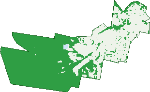
Green: 10 m cells where trees dominate, satellite 2021. Blue: water. The line is the suburb boundary.
| Canopy share, 1 m canopy height map, 2020 | 57.6% |
|---|---|
| Land with trees, 10 m satellite map, 2021 | 60.1% |
Demographics
Unemployment 3.1% · Labour-force participation 74.2%
Population by age in Enoggera
| 0-4 | 345 |
|---|---|
| 5-14 | 683 |
| 15-19 | 382 |
| 20-24 | 773 |
| 25-34 | 1,154 |
| 35-44 | 845 |
| 45-54 | 720 |
| 55-64 | 426 |
| 65-74 | 276 |
| 75-84 | 165 |
| 85+ | 84 |
Dwelling types in Enoggera
| House | 1,300 |
|---|---|
| Townhouse | 270 |
| Apartment | 475 |
| Other | 0 |
Households by weekly income in Enoggera
| <$650 | 286 |
|---|---|
| $650-1,499 | 386 |
| $1,500-2,999 | 609 |
| $3,000+ | 657 |
Top ancestries in Enoggera
| English | 2,192 |
|---|---|
| Australian | 2,064 |
| Irish | 925 |
| Other | 684 |
| Scottish | 674 |
| Ancestry NS | 395 |
Housing tenure in Enoggera
| Owned | 413 |
|---|---|
| Mortgage | 667 |
| Rented | 932 |
| Other | 33 |
Cars per household in Enoggera
| 0 | 189 |
|---|---|
| 1 | 834 |
| 2 | 747 |
| 3 | 193 |
| 4+ | 82 |
Commute to work in Enoggera
| Car | 1,554 |
|---|---|
| Train | 161 |
| Bus | 69 |
| Tram/ferry | 0 |
| Walked | 285 |
| Bicycle | 109 |
| Home | 781 |
Top countries of birth in Enoggera
| England | 160 |
|---|---|
| New Zealand | 111 |
| India | 109 |
| China | 47 |
| Philippines | 34 |
| Ireland | 29 |
Languages used at home in Enoggera
| Mandarin | 68 |
|---|---|
| Spanish | 55 |
| Hindi | 43 |
| Italian | 33 |
| Nepali | 26 |
| French | 23 |
Birds & Wildlife Nearby
76,807 bird observations recorded near Enoggera — most often seen:
- Noisy Miner (5,964)
- Rainbow Lorikeet (5,510)
- Torresian Crow (5,467)
- Australian Magpie (3,670)
- Grey Butcherbird (3,510)
- Pied Currawong (3,405)
- Laughing Kookaburra (3,235)
- Welcome Swallow (3,181)
- Australian Brush-turkey (2,936)
- Pied Butcherbird (2,903)
- Magpie-lark (2,847)
- Australasian Figbird (2,523)
- Scaly-breasted Lorikeet (2,465)
Show all 30 birds recorded near Enoggera
- Australian White Ibis (2,454)
- Blue-faced Honeyeater (2,315)
- Sulphur-crested Cockatoo (2,189)
- Crested Pigeon (1,888)
- Pacific Black Duck (1,870)
- Willie Wagtail (1,842)
- Dusky Moorhen (1,759)
- Spotted Turtle-dove (1,734)
- Galah (1,548)
- Rock Dove (1,535)
- Black-faced Cuckoo-shrike (1,534)
- Lewin's Honeyeater (1,507)
- Spangled Drongo (1,421)
- Eastern Whipbird (1,409)
- Striated Pardalote (1,407)
- Olive-backed Oriole (1,398)
- Masked Lapwing (1,381)
Sightings reported by observers, not a survey, so the counts show what people record rather than what lives here. Source: Atlas of Living Australia.
Nearby Suburbs
The closest suburbs to Enoggera:
- Alderley (1 km)
- Gaythorne (1 km)
- Newmarket (2.2 km)
- Mitchelton (2.3 km)
- Everton Park (2.3 km)
- Ashgrove (2.4 km)
- Grange (2.4 km)
- Stafford (2.6 km)
Embed this suburb
Add this free Enoggera stat card to your own site — just copy the code:
Preview:
Cite this page
Quoting these figures? Copy the credit line:
Keep an eye on Enoggera
One email when this data meaningfully changes — new census figures, prices, rankings. No spam, unsubscribe anytime.
Streets
- Ardentallen Road (47)
- Audrey Street (6)
- Bakey Lane (2)
- Banks Street (1)
- Bauhinia Avenue (19)
- Bond Street (34)
- Bowling Street (2)
- Brevis Lane (13)
- Browns Dip Road (65)
- Cairo Street (39)
- Camborne Street (8)
- Chathams Post Street (22)
- Chauvel Drive (3)
- Cherry Street (1)
- Clover Street (35)
- Clunies Ross Court (21)
- Corbett Street (15)
- Crescent Avenue (29)
- Dalmarnock Street (22)
- Derby Lane (5)
- Douglas Street (22)
- Edith Street (28)
- Elfreda Street (26)
- Elkhorn Street (111)
- Fern Street (30)
- Gizeh Street (27)
- Glenalva Terrace (176)
- Gratwick Street (1)
- Harding Street (51)
- Harley Street (9)
- Hawthorne Street (101)
- Helles Road (7)
- Hilda Street (26)
- Hurdcotte Street (73)
- Imbros Street (2)
- Kinnen Street (12)
- Lady Galway Street (32)
- Laruma Street (2)
- Laurel Street (83)
- Lloyd Street (82)
- Lone Pine Street (26)
- Magura Street (15)
- Malcolm Street (19)
- Millen Street (46)
- Mittagong Street (28)
- Moore Street (41)
- Norman Terrace (69)
- O'connell Place (20)
- Oconnell Drive (20)
- Orchid Street (98)
- Peters Street (3)
- Pickering Street (295)
- Picnic Street (24)
- Pratt Street (65)
- Samford Road (284)
- Settlement Road (4)
- Shelford Street (2)
- Shirley Street (26)
- Sicklefield Road (22)
- South Pine Road (201)
- Staghorn Street (91)
- Station Avenue (5)
- Stirling Street (38)
- Taurama Street (3)
- Trundle Street (116)
- Tunba Street (12)
- Ungalla Street (35)
- View Road (14)
- Wanimo Street (1)
- Wardell Street (205)
- Wattle Street (25)
- Willandra Street (35)
- Yarrabee Road (3)