Ashgrove QLD 4060
6,912 addresses · 178 streets
Brisbane Electorate › Brisbane LGA › Ashgrove · 5 km from Brisbane
📦 Thinking of moving here? Read the Ashgrove moving guide

Living Here
Ashgrove is a suburb of Queensland, home to about 13,450 people, with a median age of 38. The typical household earns around $2,874 a week, with median rent near $440 a week. Most homes are houses. About 72% of households own their home and 27% rent. Most workers drive to work. Common community backgrounds include English, Australian, Irish. On the ABS socio-economic scale it sits in decile 10 of 10 nationally — a relatively advantaged area.
Over time — Census 2001 → 2021
Dashed line: district figures for the Ashgrove statistical area (SA2), the smallest area the ABS published before 2011. Solid line: Ashgrove itself.
Getting Around & Local Services
23 childcare & kindergartens
2 butchers
Getting around. Train station: Newmarket, 2.5 km north-east · Bus interchange: Enoggera interchange, 2.5 km north · Ferry wharf: Milton ferry terminal, 3.8 km south-east · Airport: Brisbane Airport, 15 km north-east.
Socio-economic Standing
Deciles from 1 (lowest) to 10 (highest), against all Australian suburbs. The overall figure weighs advantage and disadvantage together; economic resources counts income and housing, and education & jobs counts qualifications and occupation. They often differ. Source: ABS SEIFA 2021.
Tree cover
🌳 Tree canopy: 27.5% share of land under canopy · satellite map, 2020
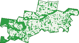
Green: 10 m cells where trees dominate, satellite 2021. Blue: water. The line is the suburb boundary.
| Canopy share, 1 m canopy height map, 2020 | 27.5% |
|---|---|
| Land with trees, 10 m satellite map, 2021 | 38.1% |
Demographics
Unemployment 3.7% · Labour-force participation 73%
Population by age in Ashgrove
| 0-4 | 685 |
|---|---|
| 5-14 | 2,111 |
| 15-19 | 1,172 |
| 20-24 | 904 |
| 25-34 | 1,332 |
| 35-44 | 1,830 |
| 45-54 | 2,267 |
| 55-64 | 1,545 |
| 65-74 | 966 |
| 75-84 | 458 |
| 85+ | 187 |
Dwelling types in Ashgrove
| House | 3,583 |
|---|---|
| Townhouse | 90 |
| Apartment | 956 |
| Other | 5 |
Households by weekly income in Ashgrove
| <$650 | 428 |
|---|---|
| $650-1,499 | 741 |
| $1,500-2,999 | 1,088 |
| $3,000+ | 2,119 |
Top ancestries in Ashgrove
| English | 5,469 |
|---|---|
| Australian | 4,921 |
| Irish | 2,839 |
| Scottish | 1,869 |
| Other | 1,304 |
| German | 811 |
Housing tenure in Ashgrove
| Owned | 1,438 |
|---|---|
| Mortgage | 1,879 |
| Rented | 1,249 |
| Other | 40 |
Cars per household in Ashgrove
| 0 | 233 |
|---|---|
| 1 | 1,646 |
| 2 | 1,824 |
| 3 | 616 |
| 4+ | 289 |
Commute to work in Ashgrove
| Car | 3,414 |
|---|---|
| Train | 24 |
| Bus | 336 |
| Tram/ferry | 0 |
| Walked | 157 |
| Bicycle | 100 |
| Home | 2,226 |
Top countries of birth in Ashgrove
| England | 563 |
|---|---|
| New Zealand | 329 |
| South Africa | 126 |
| United States | 109 |
| India | 104 |
| Scotland | 78 |
Languages used at home in Ashgrove
| Spanish | 137 |
|---|---|
| Mandarin | 111 |
| Italian | 84 |
| Hindi | 66 |
| German | 59 |
| Portuguese | 55 |
Birds & Wildlife Nearby
118,772 bird observations recorded near Ashgrove — most often seen:
- Noisy Miner (9,268)
- Torresian Crow (8,345)
- Rainbow Lorikeet (7,713)
- Australian White Ibis (5,858)
- Pied Currawong (5,782)
- Welcome Swallow (5,487)
- Australian Brush-turkey (5,287)
- Australian Magpie (5,277)
- Australasian Figbird (4,451)
- Sulphur-crested Cockatoo (4,433)
- Magpie-lark (4,408)
- Grey Butcherbird (4,383)
- Laughing Kookaburra (4,178)
Show all 30 birds recorded near Ashgrove
- Pied Butcherbird (3,934)
- Scaly-breasted Lorikeet (3,775)
- Rock Dove (3,638)
- Blue-faced Honeyeater (3,595)
- Dusky Moorhen (3,084)
- Pacific Black Duck (2,854)
- Willie Wagtail (2,446)
- Lewin's Honeyeater (2,380)
- Crested Pigeon (2,356)
- Masked Lapwing (2,189)
- Spotted Turtle-dove (2,182)
- Australian Wood Duck (2,009)
- Eastern Whipbird (1,922)
- Common Myna (1,899)
- Spangled Drongo (1,899)
- Bush Stone-curlew (1,878)
- Striated Pardalote (1,862)
Sightings reported by observers, not a survey, so the counts show what people record rather than what lives here. Source: Atlas of Living Australia.
Nearby Suburbs
The closest suburbs to Ashgrove:
- Red Hill (1.9 km)
- Bardon (2 km)
- Paddington (2.2 km)
- Newmarket (2.2 km)
- Alderley (2.4 km)
- Enoggera (2.4 km)
- Kelvin Grove (2.6 km)
- Gaythorne (3 km)
Embed this suburb
Add this free Ashgrove stat card to your own site — just copy the code:
Preview:
Cite this page
Quoting these figures? Copy the credit line:
Keep an eye on Ashgrove
One email when this data meaningfully changes — new census figures, prices, rankings. No spam, unsubscribe anytime.
Streets
- Acacia Drive (97)
- Acton Street (19)
- Ajax Lane (2)
- Aloomba Road (21)
- Amarina Avenue (48)
- Anderson Avenue (20)
- Arinya Road (40)
- Ashbourne Street (36)
- Ashgrove Avenue (368)
- Ashgrove Crescent (50)
- Atthow Avenue (45)
- Baileys Road (55)
- Banks Street (46)
- Banksia Avenue (33)
- Banool Street (30)
- Bennett Avenue (4)
- Beth Eden Terrace (67)
- Bilbai Street (1)
- Boon Street (6)
- Bott Street (124)
- Bracknell Place (17)
- Bridge Street (7)
- Brisbane Street (33)
- Broadbent Street (12)
- Brown Parade (65)
- Bryant Street (15)
- Buckingham Street (90)
- Buxton Street (22)
- Canberra Drive (60)
- Caneby Street (14)
- Cavell Terrace (27)
- Celia Street (56)
- Chiba Street (1)
- Coopers Camp Road (20)
- Corbie Street (12)
- Corona Avenue (41)
- Crawford Street (10)
- Creek Avenue (8)
- Cypress Drive (12)
- Dalmore Street (110)
- Davies Road (75)
- Dawn Street (1)
- Devonshire Street (46)
- Devoy Street (107)
- Dixon Street (10)
- Don Street (3)
- Dorrington Drive (67)
- Dorset Street (169)
- Dovedale Crescent (35)
- Eagar Street (6)
- Elimatta Drive (28)
- Elouera Road (22)
- Exeter Street (38)
- Farrell Street (52)
- Felicia Street (7)
- Felton Street (8)
- Ferneydell Street (29)
- Findlay Street (19)
- Firhill Street (8)
- Foch Street (24)
- Frasers Road (72)
- Frobisher Street (18)
- Fulcher Road (5)
- Gailey Street (36)
- Garden Grove (8)
- Gavan Street (40)
- Girraween Grove (53)
- Givelda Street (5)
- Glasgow Street (15)
- Glen Parade (13)
- Glenlyon Drive (57)
- Glenquarie Place (14)
- Globe Street (124)
- Glory Street (15)
- Gramere Avenue (26)
- Grand Parade (18)
- Grant Street (15)
- Greenlanes Road (42)
- Greenmont Close (28)
- Greenwood Street (4)
- Gresham Street (19)
- Grevillea Road (68)
- Hackett Street (20)
- Haig Street (10)
- Harding Street (28)
- Harry Street (25)
- Havana Street (20)
- Hawick Street (16)
- Hawthorne Avenue (16)
- Hibiscus Avenue (30)
- High Street (40)
- Holmesbrook Street (86)
- Jaloon Street (25)
- Joffre Street (36)
- Jubilee Terrace (74)
- Judith Street (14)
- Kadanga Street (21)
- Kauri Road (44)
- Killawarra Road (23)
- Kinkade Avenue (17)
- Kinnaird Street (85)
- Laird Street (13)
- Lansbury Parade (29)
- Lark Avenue (1)
- Laruma Street (1)
- Lindsay Street (78)
- London Street (23)
- Lovekin Street (20)
- Lynwood Crescent (7)
- Mara Place (6)
- Mareeba Road (65)
- Matlock Street (21)
- Mccormack Avenue (54)
- Mclean Parade (67)
- Milpera Street (28)
- Mirrabooka Road (30)
- Monoplane Street (9)
- Moola Road (71)
- Mossvale Street (24)
- Moulton Street (42)
- Myagah Road (38)
- Nathan Avenue (145)
- Nicholson Lane (5)
- Noeline Street (14)
- Oleander Drive (53)
- Orchard Road (6)
- Othaki Road (4)
- Otonga Road (26)
- Panorama Street (41)
- Park Avenue (8)
- Pavonia Street (10)
- Philomene Drive (8)
- Piddington Street (47)
- Plant Street (13)
- Pops Street (5)
- Quandong Street (82)
- Raleigh Parade (27)
- Rangeview Place (3)
- Romani Street (5)
- Roy Street (49)
- Royal Parade (117)
- Saint Johns Avenue (62)
- Saint Vincent Street (59)
- Shirley Street (1)
- Somme Street (24)
- Stark Street (8)
- Steege Street (12)
- Stewart Place (13)
- Stewart Road (131)
- Sunrise Street (27)
- Tay Street (11)
- Teale Street (8)
- Tennis Avenue (22)
- The Crescent (4)
- The Esplanade (14)
- Theale Terrace (13)
- Todd Street (35)
- Toomba Avenue (33)
- Trinder Road (22)
- Trout Street (90)
- Tweed Street (26)
- Uralla Street (11)
- Vaux Street (4)
- Venus Street (11)
- Victoria Street (45)
- View Parade (7)
- Wahroonga Road (15)
- Wardell Street (97)
- Warmington Road (17)
- Waterworks Road (695)
- Weatherhead Avenue (60)
- Wessex Lane (14)
- Wing Street (2)
- Woodland Street (65)
- Woonga Drive (40)
- Yardley Avenue (30)
- Yates Avenue (22)
- Yoku Road (44)