Cranbrook QLD 4814
3,083 addresses · 107 streets
Herbert Electorate › Townsville LGA › Cranbrook · 1111 km from Brisbane
📦 Thinking of moving here? Read the Cranbrook moving guide

Living Here
Cranbrook is a suburb of Queensland, home to about 5,844 people, with a median age of 40. The typical household earns around $1,400 a week, with median rent near $293 a week. Most homes are houses. About 65% of households own their home and 32% rent. Most workers drive to work. Common community backgrounds include Australian, English, Irish. On the ABS socio-economic scale it sits in decile 3 of 10 nationally — a more disadvantaged area.
Over time — Census 2001 → 2021
Dashed line: district figures for the Cranbrook statistical area (SA2), the smallest area the ABS published before 2011. Solid line: Cranbrook itself.
Getting Around & Local Services
4 supermarkets
1 Catholic church
2 dentists
2 optometrists
3 post offices
1 playground
1 bakery
2 hardware stores
2 electricians
Getting around. Train station: Townsville, 6.8 km north-east · Airport: RAAF Base Townsville, 4.8 km north.
Socio-economic Standing
Deciles from 1 (lowest) to 10 (highest), against all Australian suburbs. The overall figure weighs advantage and disadvantage together; economic resources counts income and housing, and education & jobs counts qualifications and occupation. They often differ. Source: ABS SEIFA 2021.
Tree cover
🌳 Tree canopy: 13.1% share of land under canopy · satellite map, 2020
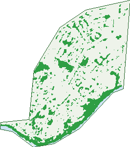
Green: 10 m cells where trees dominate, satellite 2021. Blue: water. The line is the suburb boundary.
| Canopy share, 1 m canopy height map, 2020 | 13.1% |
|---|---|
| Land with trees, 10 m satellite map, 2021 | 13.8% |
Demographics
Unemployment 7.5% · Labour-force participation 59.1%
Population by age in Cranbrook
| 0-4 | 310 |
|---|---|
| 5-14 | 689 |
| 15-19 | 356 |
| 20-24 | 425 |
| 25-34 | 757 |
| 35-44 | 655 |
| 45-54 | 726 |
| 55-64 | 731 |
| 65-74 | 606 |
| 75-84 | 459 |
| 85+ | 129 |
Dwelling types in Cranbrook
| House | 1,819 |
|---|---|
| Townhouse | 365 |
| Apartment | 48 |
| Other | 0 |
Households by weekly income in Cranbrook
| <$650 | 450 |
|---|---|
| $650-1,499 | 659 |
| $1,500-2,999 | 646 |
| $3,000+ | 317 |
Top ancestries in Cranbrook
| Australian | 2,024 |
|---|---|
| English | 1,999 |
| Other | 723 |
| Irish | 681 |
| Scottish | 608 |
| Aboriginal | 507 |
Housing tenure in Cranbrook
| Owned | 739 |
|---|---|
| Mortgage | 683 |
| Rented | 702 |
| Other | 63 |
Cars per household in Cranbrook
| 0 | 208 |
|---|---|
| 1 | 791 |
| 2 | 792 |
| 3 | 274 |
| 4+ | 133 |
Commute to work in Cranbrook
| Car | 1,957 |
|---|---|
| Train | 0 |
| Bus | 49 |
| Tram/ferry | 0 |
| Walked | 49 |
| Bicycle | 30 |
| Home | 133 |
Top countries of birth in Cranbrook
| Philippines | 182 |
|---|---|
| England | 125 |
| New Zealand | 115 |
| India | 106 |
| Papua New Guinea | 48 |
| China | 34 |
Languages used at home in Cranbrook
| Tagalog | 94 |
|---|---|
| Filipino | 68 |
| Australian Indigenous | 38 |
| Punjabi | 34 |
| Malayalam | 33 |
| Vietnamese | 31 |
Birds & Wildlife Nearby
99,652 bird observations recorded near Cranbrook — most often seen:
- Australian White Ibis (5,699)
- Rainbow Lorikeet (5,548)
- Peaceful Dove (5,347)
- Magpie-lark (5,170)
- White-gaped Honeyeater (4,960)
- Great Bowerbird (4,722)
- Brown Honeyeater (4,552)
- Common Myna (4,140)
- Rainbow Bee-eater (3,755)
- Blue-faced Honeyeater (3,715)
- Masked Lapwing (3,657)
- White-breasted Woodswallow (3,645)
- Australasian Figbird (3,495)
Show all 30 birds recorded near Cranbrook
- Sulphur-crested Cockatoo (3,038)
- Spangled Drongo (2,912)
- House Sparrow (2,870)
- Australian Magpie (2,768)
- Yellow Honeyeater (2,708)
- Bush Stone-curlew (2,705)
- Pacific Black Duck (2,561)
- Welcome Swallow (2,488)
- Spotted Turtle-dove (2,378)
- Helmeted Friarbird (2,231)
- Australasian Darter (2,228)
- Magpie Goose (2,192)
- Eastern Koel (2,095)
- Torresian Imperial-pigeon (2,036)
- Rock Dove (2,033)
- Nutmeg Munia (2,032)
- Little Friarbird (1,972)
Sightings reported by observers, not a survey, so the counts show what people record rather than what lives here. Source: Atlas of Living Australia.
Nearby Suburbs
The closest suburbs to Cranbrook:
- Heatley (1.5 km)
- Aitkenvale (1.6 km)
- Douglas (2.1 km)
- Vincent (2.5 km)
- Kirwan (2.6 km)
- Thuringowa Central (2.9 km)
- Gulliver (3 km)
- Annandale (3.3 km)
Embed this suburb
Add this free Cranbrook stat card to your own site — just copy the code:
Preview:
Cite this page
Quoting these figures? Copy the credit line:
Keep an eye on Cranbrook
One email when this data meaningfully changes — new census figures, prices, rankings. No spam, unsubscribe anytime.
Streets
- Acheron Avenue (38)
- Addison Court (8)
- Adelong Drive (20)
- Albert Street (199)
- Alice Street (23)
- Alleena Street (20)
- Aloomba Crescent (19)
- Angela Court (15)
- Ansell Court (5)
- Arila Street (27)
- Arinya Street (13)
- Arunta Street (7)
- Ash Street (5)
- Astill Court (15)
- Badelona Street (24)
- Baralga Street (34)
- Barellan Street (29)
- Barrallier Place (14)
- Bauhinia Street (30)
- Behan Court (13)
- Bergin Road (156)
- Berontha Street (33)
- Biara Street (7)
- Binda Street (1)
- Blanes Street (26)
- Blee Court (5)
- Bloom Court (9)
- Borral Street (8)
- Brampton Avenue (39)
- Brett Street (15)
- Bryant Street (22)
- Cabarita Street (14)
- Cadiz Court (6)
- Camira Avenue (16)
- Canara Court (8)
- Canara Street (47)
- Carcoola Street (11)
- Carlisle Street (13)
- Castellana Street (9)
- Charles Street (71)
- Choonda Street (38)
- Cordelia Avenue (28)
- Corres Court (6)
- Courtney Street (11)
- Dalpura Avenue (17)
- Ellimatta Avenue (29)
- Fitzroy Street (39)
- Frangipani Street (12)
- Fraser Avenue (34)
- Gilli Crescent (23)
- Hatchett Street (27)
- Hayman Avenue (20)
- Hibiscus Street (25)
- Illoura Street (20)
- Irving Street (8)
- Isabella Court (12)
- Jandera Street (18)
- Jannila Avenue (50)
- Jarrah Court (7)
- Joy Street (3)
- Kalinya Court (12)
- Kieran Court (6)
- Killara Street (22)
- Kilroy Court (10)
- Kirrang Court (7)
- Laburnum Street (26)
- Lara Street (17)
- Lindeman Avenue (212)
- Lloret Court (4)
- Louise Street (39)
- Lumeah Street (14)
- Lutana Court (15)
- Marbella Street (5)
- Marloo Street (15)
- Marlynda Avenue (40)
- Mathiesen Street (34)
- Moondarga Drive (26)
- Nathan Street (94)
- Northwest Crescent (28)
- Nowland Avenue (21)
- Nunana Street (3)
- Orchid Street (16)
- Paringa Street (17)
- Parkview Court (18)
- Parnell Court (16)
- Picton Court (13)
- Pingel Court (6)
- Platt Court (7)
- Poinciana Street (60)
- Raynor Street (3)
- Ross River Road (415)
- Rossiter Street (39)
- Selwyn Street (17)
- Serrano Crescent (30)
- Silky Oak Street (8)
- Simon Court (5)
- Sotelo Street (18)
- Tingha Street (14)
- Trickey Avenue (17)
- Undara Avenue (49)
- Valencia Street (32)
- Victor Street (24)
- Wanda Avenue (4)
- Wandella Crescent (37)
- Wattle Street (38)
- Weela Street (16)
- Wooral Street (13)