Annandale QLD 4814
3,256 addresses · 155 streets
Dawson Electorate › Townsville LGA › Annandale · 1108 km from Brisbane
📦 Thinking of moving here? Read the Annandale moving guide

Living Here
Annandale is a suburb of Queensland, home to about 8,376 people, with a median age of 40. The typical household earns around $2,238 a week, with median rent near $380 a week. Most homes are houses. About 75% of households own their home and 24% rent. Most workers drive to work. Common community backgrounds include English, Australian, Irish. On the ABS socio-economic scale it sits in decile 8 of 10 nationally — a relatively advantaged area.
Over time — Census 2001 → 2021
Dashed line: district figures for the Annandale statistical area (SA2), the smallest area the ABS published before 2011. Solid line: Annandale itself.
Getting Around & Local Services
25 schools
3 supermarkets
1 Catholic church
2 pharmacies
1 dentist
2 optometrists
2 childcare & kindergartens
2 bakeries
1 butcher
4 hardware stores
2 hairdressers
2 electricians
Getting around. Train station: Townsville, 5.3 km north-east · Ferry wharf: Magnetic Island Ferries - Townsville Terminal, 7.6 km north-east · Airport: RAAF Base Townsville, 5.6 km north.
Socio-economic Standing
Deciles from 1 (lowest) to 10 (highest), against all Australian suburbs. The overall figure weighs advantage and disadvantage together; economic resources counts income and housing, and education & jobs counts qualifications and occupation. They often differ. Source: ABS SEIFA 2021.
Tree cover
🌳 Tree canopy: 11.4% share of land under canopy · satellite map, 2020
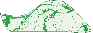
Green: 10 m cells where trees dominate, satellite 2021. Blue: water. The line is the suburb boundary.
| Canopy share, 1 m canopy height map, 2020 | 11.4% |
|---|---|
| Land with trees, 10 m satellite map, 2021 | 18.2% |
Demographics
Unemployment 4.1% · Labour-force participation 66.2%
Population by age in Annandale
| 0-4 | 374 |
|---|---|
| 5-14 | 1,258 |
| 15-19 | 724 |
| 20-24 | 489 |
| 25-34 | 813 |
| 35-44 | 993 |
| 45-54 | 1,257 |
| 55-64 | 1,109 |
| 65-74 | 786 |
| 75-84 | 407 |
| 85+ | 162 |
Dwelling types in Annandale
| House | 2,784 |
|---|---|
| Townhouse | 0 |
| Apartment | 0 |
| Other | 0 |
Households by weekly income in Annandale
| <$650 | 238 |
|---|---|
| $650-1,499 | 552 |
| $1,500-2,999 | 900 |
| $3,000+ | 846 |
Top ancestries in Annandale
| English | 3,237 |
|---|---|
| Australian | 2,823 |
| Irish | 1,064 |
| Scottish | 974 |
| Other | 848 |
| Italian | 533 |
Housing tenure in Annandale
| Owned | 1,003 |
|---|---|
| Mortgage | 1,074 |
| Rented | 670 |
| Other | 21 |
Cars per household in Annandale
| 0 | 38 |
|---|---|
| 1 | 700 |
| 2 | 1,339 |
| 3 | 472 |
| 4+ | 211 |
Commute to work in Annandale
| Car | 3,292 |
|---|---|
| Train | 0 |
| Bus | 22 |
| Tram/ferry | 0 |
| Walked | 51 |
| Bicycle | 74 |
| Home | 204 |
Top countries of birth in Annandale
| England | 230 |
|---|---|
| India | 187 |
| New Zealand | 179 |
| South Africa | 110 |
| China | 87 |
| Philippines | 75 |
Languages used at home in Annandale
| Mandarin | 104 |
|---|---|
| Malayalam | 100 |
| Afrikaans | 65 |
| Korean | 59 |
| Hindi | 57 |
| Italian | 51 |
Birds & Wildlife Nearby
67,333 bird observations recorded near Annandale — most often seen:
- Australian White Ibis (3,817)
- Rainbow Lorikeet (3,572)
- Masked Lapwing (3,204)
- Peaceful Dove (3,085)
- Magpie-lark (3,080)
- Great Bowerbird (2,761)
- White-gaped Honeyeater (2,738)
- Rainbow Bee-eater (2,605)
- Blue-faced Honeyeater (2,583)
- Pacific Black Duck (2,495)
- Brown Honeyeater (2,327)
- Australasian Figbird (2,313)
- Spangled Drongo (2,204)
Show all 30 birds recorded near Annandale
- Australasian Darter (2,176)
- Common Myna (2,116)
- Magpie Goose (2,085)
- Sulphur-crested Cockatoo (2,048)
- Welcome Swallow (2,044)
- Little Black Cormorant (1,875)
- Yellow Honeyeater (1,829)
- Comb-crested Jacana (1,795)
- White-breasted Woodswallow (1,789)
- Little Pied Cormorant (1,787)
- Bush Stone-curlew (1,747)
- Australian Magpie (1,657)
- Helmeted Friarbird (1,649)
- Intermediate Egret (1,588)
- Australian Brush-turkey (1,553)
- Little Friarbird (1,424)
- White-throated Honeyeater (1,387)
Sightings reported by observers, not a survey, so the counts show what people record rather than what lives here. Source: Atlas of Living Australia.
Nearby Suburbs
The closest suburbs to Annandale:
- Mundingburra (1.7 km)
- Aitkenvale (2.2 km)
- Rosslea (2.2 km)
- Murray (2.6 km)
- Idalia (2.9 km)
- Mysterton (2.9 km)
- Gulliver (3.1 km)
- Cranbrook (3.3 km)
Embed this suburb
Add this free Annandale stat card to your own site — just copy the code:
Preview:
Cite this page
Quoting these figures? Copy the credit line:
Keep an eye on Annandale
One email when this data meaningfully changes — new census figures, prices, rankings. No spam, unsubscribe anytime.
Streets
- Allamanda Crescent (40)
- Alloway Court (17)
- Almora Place (7)
- Amarina Court (6)
- Annandale Drive (54)
- Argyle Court (10)
- Banyan Court (15)
- Barkley Court (5)
- Begonia Court (16)
- Bendigo Court (12)
- Berrigan Avenue (26)
- Bladensberg Crescent (36)
- Boomarra Court (20)
- Boronia Drive (56)
- Brazier Drive (36)
- Brickondon Crescent (37)
- Brooklyn Court (24)
- Burgess Street (20)
- Burnside Court (9)
- Camden Court (14)
- Camellia Court (12)
- Canoona Court (13)
- Cargillea Avenue (19)
- Cargoon Court (10)
- Carisbrooke Court (11)
- Cashmere Court (10)
- Cassia Court (14)
- Casuarina Drive (55)
- Chatsworth Crescent (30)
- Cobb Court (12)
- Coleraine Street (21)
- Coleus Court (17)
- Coolullah Court (12)
- Cupania Court (14)
- Cycad Court (6)
- Cypress Drive (83)
- Davencourt Place (11)
- Dianella Court (9)
- Dotswood Court (5)
- Downey Crescent (34)
- Elderslie Street (26)
- Emmet Court (13)
- Escott Place (4)
- Eucalyptus Avenue (59)
- Eumara Court (6)
- Fairlight Crescent (9)
- Fardon Street (36)
- Gartrell Drive (4)
- Gledhill Court (16)
- Glencoe Court (13)
- Glendale Drive (30)
- Glenelg Court (13)
- Hazelwood Court (26)
- Honeysuckle Drive (61)
- Hoya Court (11)
- Indigo Crescent (26)
- Jacaranda Crescent (43)
- Jacobsen Court (12)
- Jade Court (4)
- Jasmine Court (15)
- Jenkinson Drive (43)
- Jireena Court (8)
- Jondaryn Court (15)
- Jonquil Crescent (36)
- Kamaran Court (13)
- Karvella Street (16)
- Kearney Court (11)
- Kendall Street (9)
- Kidner Place (10)
- Killymoon Crescent (27)
- Kulwin Court (10)
- Kylie Court (10)
- Kyong Place (12)
- Larkspur Crescent (28)
- Laroona Court (11)
- Lerew Court (13)
- Linaria Court (19)
- Linaria Crescent (19)
- Lolworth Court (11)
- Lupin Court (13)
- Macarthur Drive (80)
- Magnolia Court (13)
- Manersley Place (34)
- Marabou Drive (80)
- Marigold Court (13)
- Masuda Street (41)
- Mayneside Circuit (56)
- Mccullough Court (14)
- Mead Court (4)
- Melaleuca Street (21)
- Mervyn Crossman Drive (11)
- Millet Street (9)
- Mimosa Court (28)
- Miranda Circle (33)
- Mona Vale Place (24)
- Morstone Street (42)
- Murray Lyons Crescent (5)
- Musa Court (4)
- Myrtle Court (7)
- Neale Court (9)
- Niall Court (15)
- Nicholson Court (12)
- Nicol Court (6)
- Nowranie Court (15)
- Nutwood Court (17)
- Oban Court (12)
- Oleander Street (13)
- Oondooroo Court (18)
- Owens Court (11)
- Pajingo Court (8)
- Patterson Street (11)
- Pentas Court (9)
- Perrin Court (17)
- Pilea Court (12)
- River Park Drive (162)
- Rosebud Place (5)
- Rosedale Court (13)
- Roxmere Court (3)
- Sage Court (8)
- Sandbek Street (36)
- Serissa Crescent (51)
- Shanahan Drive (1)
- Sinclair Street (10)
- Southwick Court (11)
- Starcross Court (14)
- Strathmore Court (9)
- Sunbury Court (26)
- Sutherland Street (14)
- Taldora Place (8)
- Tandamus Court (24)
- Tibouchina Street (14)
- Timaru Court (12)
- Tiree Street (5)
- University Road (6)
- Verbena Court (7)
- Vindex Court (9)
- Viola Court (16)
- Viola Crescent (16)
- Waterloo Place (5)
- Wave Hill Drive (36)
- Weddel Drive (53)
- Werribee Court (11)
- Willeroo Court (14)
- Wingadee Court (7)
- Wiranda Court (6)
- Wistaria Court (14)
- Wolseley Court (20)
- Woodbine Drive (38)
- Woodhouse Court (13)
- Wynberg Drive (58)
- Wyuna Street (4)
- Yeldham Court (14)
- Yolanda Drive (140)
- Zamia Court (13)
- Zinnia Court (7)