Chermside West QLD 4032
3,143 addresses · 121 streets
Lilley Electorate › Brisbane LGA › Chermside West · 10 km from Brisbane
📦 Thinking of moving here? Read the Chermside West moving guide

Living Here
Chermside West is a suburb of Queensland, home to about 6,965 people, with a median age of 39. The typical household earns around $2,124 a week, with median rent near $455 a week. Most homes are houses. About 72% of households own their home and 25% rent. Most workers drive to work. Common community backgrounds include English, Australian, Irish. On the ABS socio-economic scale it sits in decile 9 of 10 nationally — a relatively advantaged area.
Over time — Census 2001 → 2021
Dashed line: district figures for the Chermside West statistical area (SA2), the smallest area the ABS published before 2011. Solid line: Chermside West itself.
Getting Around & Local Services
25 Catholic churches
18 childcare & kindergartens
- Happy Tots Education on Hamilton
- Bright Beginnings Child Edu-Care Centre
- West Chermside C&K Pre-Prep
- Craigslea Kindergarten
- Guppy's Early Learning Centre
- Goodstart Stafford Heights
- Guardian Childcare & Education Aspley
- Avenues Early Learning Centre Aspley
- Stafford Heights Kindergarten
- Kedron Heights Community Kindergarten
2 bakeries
Getting around. Train station: Zillmere station, 3.7 km north-east · Bus interchange: Chermside bus station, 1.8 km east · Ferry wharf: Bretts Wharf Ferry Terminal, 8 km south-east · Airport: Brisbane Airport, 10.8 km east.
Socio-economic Standing
Deciles from 1 (lowest) to 10 (highest), against all Australian suburbs. The overall figure weighs advantage and disadvantage together; economic resources counts income and housing, and education & jobs counts qualifications and occupation. They often differ. Source: ABS SEIFA 2021.
Tree cover
🌳 Tree canopy: 26.4% share of land under canopy · satellite map, 2020
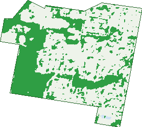
Green: 10 m cells where trees dominate, satellite 2021. Blue: water. The line is the suburb boundary.
| Canopy share, 1 m canopy height map, 2020 | 26.4% |
|---|---|
| Land with trees, 10 m satellite map, 2021 | 34.7% |
Demographics
Unemployment 4.6% · Labour-force participation 63.3%
Population by age in Chermside West
| 0-4 | 386 |
|---|---|
| 5-14 | 850 |
| 15-19 | 398 |
| 20-24 | 436 |
| 25-34 | 913 |
| 35-44 | 963 |
| 45-54 | 833 |
| 55-64 | 733 |
| 65-74 | 569 |
| 75-84 | 552 |
| 85+ | 330 |
Dwelling types in Chermside West
| House | 2,214 |
|---|---|
| Townhouse | 68 |
| Apartment | 203 |
| Other | 0 |
Households by weekly income in Chermside West
| <$650 | 290 |
|---|---|
| $650-1,499 | 551 |
| $1,500-2,999 | 779 |
| $3,000+ | 714 |
Top ancestries in Chermside West
| English | 2,394 |
|---|---|
| Australian | 2,282 |
| Irish | 952 |
| Other | 806 |
| Scottish | 767 |
| Italian | 426 |
Housing tenure in Chermside West
| Owned | 879 |
|---|---|
| Mortgage | 886 |
| Rented | 600 |
| Other | 81 |
Cars per household in Chermside West
| 0 | 113 |
|---|---|
| 1 | 831 |
| 2 | 1,042 |
| 3 | 296 |
| 4+ | 172 |
Commute to work in Chermside West
| Car | 2,059 |
|---|---|
| Train | 19 |
| Bus | 130 |
| Tram/ferry | 0 |
| Walked | 64 |
| Bicycle | 24 |
| Home | 618 |
Top countries of birth in Chermside West
| New Zealand | 259 |
|---|---|
| India | 239 |
| England | 188 |
| China | 107 |
| Philippines | 96 |
| Italy | 76 |
Languages used at home in Chermside West
| Malayalam | 205 |
|---|---|
| Mandarin | 122 |
| Italian | 121 |
| Cantonese | 81 |
| Tagalog | 47 |
| Hindi | 44 |
Birds & Wildlife Nearby
111,874 bird observations recorded near Chermside West — most often seen:
- Rainbow Lorikeet (8,165)
- Torresian Crow (8,018)
- Noisy Miner (7,937)
- Laughing Kookaburra (5,002)
- Magpie-lark (4,967)
- Grey Butcherbird (4,823)
- Australian Magpie (4,680)
- Welcome Swallow (4,618)
- Pied Butcherbird (4,585)
- Pied Currawong (4,500)
- Australian Brush-turkey (3,816)
- Australian White Ibis (3,735)
- Scaly-breasted Lorikeet (3,595)
Show all 30 birds recorded near Chermside West
- Willie Wagtail (3,429)
- Australasian Figbird (3,412)
- Rock Dove (3,142)
- Spotted Turtle-dove (3,009)
- Crested Pigeon (2,873)
- Blue-faced Honeyeater (2,801)
- Pacific Black Duck (2,722)
- Brown Honeyeater (2,625)
- Dusky Moorhen (2,466)
- Sulphur-crested Cockatoo (2,343)
- Black-faced Cuckoo-shrike (2,187)
- Masked Lapwing (2,186)
- Striated Pardalote (2,116)
- Noisy Friarbird (2,086)
- Galah (2,076)
- Australian Wood Duck (1,989)
- Lewin's Honeyeater (1,971)
Sightings reported by observers, not a survey, so the counts show what people record rather than what lives here. Source: Atlas of Living Australia.
Nearby Suburbs
The closest suburbs to Chermside West:
- Stafford Heights (1.6 km)
- Chermside (1.7 km)
- Aspley (2.1 km)
- Mcdowall (2.2 km)
- Stafford (2.8 km)
- Kedron (2.8 km)
- Everton Park (3.1 km)
- Geebung (3.5 km)
Embed this suburb
Add this free Chermside West stat card to your own site — just copy the code:
Preview:
Cite this page
Quoting these figures? Copy the credit line:
Keep an eye on Chermside West
One email when this data meaningfully changes — new census figures, prices, rankings. No spam, unsubscribe anytime.
Streets
- Ainsdale Street (34)
- Allamanda Place (18)
- Ashley Road (57)
- Ashworth Street (6)
- Bachmann Street (9)
- Backford Street (39)
- Ballinger Street (12)
- Bamber Street (19)
- Basnett Street (101)
- Ben Street (30)
- Bigi Street (20)
- Billing Street (12)
- Birra Street (46)
- Blenheim Street (49)
- Bramcote Street (28)
- Brelox Street (28)
- Buran Street (11)
- Butterfield Place (19)
- Castlehaven Close (8)
- Cherston Street (13)
- Chevrotain Place (19)
- Chingford Street (50)
- Chital Place (17)
- Chuter Street (1)
- Covey Street (17)
- Craigslea Street (19)
- Cranbourne Street (31)
- Culworth Street (11)
- Dalkeith Street (13)
- Decker Street (12)
- Delan Street (14)
- Denby Street (4)
- Dibbil Street (19)
- Dundalli Street (34)
- Eastbourne Street (29)
- Ennerdale Street (11)
- Fairlane Street (24)
- Fallow Street (10)
- Federation Street (75)
- Felsman Street (23)
- Florentine Street (21)
- Freeland Lane (1)
- Gibum Street (29)
- Gilmour Street (37)
- Girraman Street (20)
- Glenrowen Street (13)
- Graymond Street (38)
- Gresford Street (16)
- Gulawa Street (2)
- Hamilton Road (115)
- Hanbury Street (18)
- Harrison Court (7)
- Hillside Circuit (29)
- Huxtable Street (11)
- Jaguar Street (34)
- Kaiyar Street (17)
- Kanofski Street (38)
- Kenna Street (47)
- Killarney Place (14)
- Kinnerton Street (14)
- Kittabilla Street (6)
- Knutsford Street (34)
- Koonya Street (9)
- Kurago Street (30)
- Lawrence Road (35)
- Lenz Street (5)
- Letizia Close (7)
- Lindale Street (20)
- Lupton Street (12)
- Marban Street (24)
- Marford Street (25)
- Markway Street (11)
- Martindale Street (15)
- Maundrell Terrace (92)
- Mayled Street (35)
- Mews Street (20)
- Milburn Street (28)
- Mirragin Street (19)
- Mugara Street (14)
- Murr Place (7)
- Narthanya Street (39)
- Nicholas Street (31)
- Nosworthy Close (7)
- Pacific Street (36)
- Packer Street (8)
- Parmiter Street (3)
- Pie Street (1)
- Pullford Street (35)
- Raven Street (4)
- Red Deer Court (7)
- Redbourne Street (43)
- Risdon Street (4)
- Rocklily Court (7)
- Rode Road (301)
- Rossett Street (27)
- Rusa Court (7)
- Safari Street (40)
- Sambar Close (35)
- Shelgate Street (25)
- Shordley Street (28)
- Sika Court (19)
- Sommerville Place (8)
- Spenlow Street (11)
- Stringybark Drive (16)
- Syma Street (24)
- Taggan Street (6)
- Toomey Street (25)
- Trafford Street (27)
- Traves Street (10)
- Trouts Road (90)
- Tullylease Place (26)
- Tyalla Street (14)
- Tyrone Street (17)
- Valiant Street (22)
- Viney Street (33)
- Waitara Street (19)
- Walpole Street (7)
- Webster Road (59)
- Whites Road (25)
- Whittaker Street (25)
- Wittacombe Street (11)