Chermside QLD 4032
10,362 addresses · 90 streets
Lilley Electorate › Brisbane LGA › Chermside · 9 km from Brisbane
📦 Thinking of moving here? Read the Chermside moving guide

Living Here
A major retail and health hub in northern Brisbane anchored by one of the country's largest shopping centres, Chermside is densifying with apartments. Households average 1.9 people and the median age is 35. Median household income is $1,419 a week, with rent around $370.
Chermside is a suburb of Queensland, home to about 11,426 people, with a median age of 35. The typical household earns around $1,419 a week, with median rent near $370 a week. Most homes are apartments. About 32% of households own their home and 63% rent. Most workers drive to work. Common community backgrounds include English, Australian, Irish. On the ABS socio-economic scale it sits in decile 5 of 10 nationally — a mid-range area.
Over time — Census 2001 → 2021
Dashed line: district figures for the Chermside statistical area (SA2), the smallest area the ABS published before 2011. Solid line: Chermside itself.
Getting Around & Local Services
23 Catholic churches
- St Gerard Majella Catholic Church
- St Therese of Lisieux Church of the Little Flower
- St Carthage's Catholic Church
- Holy Cross Church
- Our Lady of the Immaculate Conception
- St John the Baptist Catholic Church
- Saint Columba's
- Saint Agatha's Catholic Church
- Holy Trinity Catholic Church
- Our Lady Help of Christians
20 childcare & kindergartens
- Enchanted Forest Early Learning
- Goodstart Early Learning Wavell Heights
- Craigslea Kindergarten
- Kedron Heights Community Kindergarten
- Bright Beginnings Child Edu-Care Centre
- Happy Tots Education on Hamilton
- West Chermside C&K Pre-Prep
- Wavell Heights Kindergarten
- Guppy's Early Learning Centre
- Only About Children Geebung
Getting around. Train station: Geebung station, 2.5 km north-east · Bus interchange: Chermside bus station, 50 m north-east · Ferry wharf: Bretts Wharf Ferry Terminal, 6.9 km south-east · Airport: Brisbane Airport, 9 km east.
Socio-economic Standing
Deciles from 1 (lowest) to 10 (highest), against all Australian suburbs. The overall figure weighs advantage and disadvantage together; economic resources counts income and housing, and education & jobs counts qualifications and occupation. They often differ. Source: ABS SEIFA 2021.
Tree cover
🌳 Tree canopy: 14% share of land under canopy · satellite map, 2020
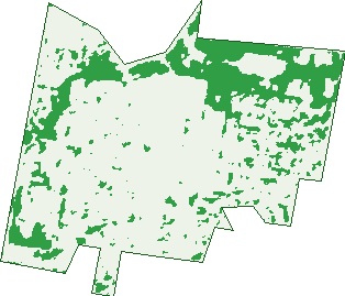
Green: 10 m cells where trees dominate, satellite 2021. Blue: water. The line is the suburb boundary.
| Canopy share, 1 m canopy height map, 2020 | 14.0% |
|---|---|
| Land with trees, 10 m satellite map, 2021 | 20.7% |
Demographics
Unemployment 6.2% · Labour-force participation 62.2%
Population by age in Chermside
| 0-4 | 536 |
|---|---|
| 5-14 | 819 |
| 15-19 | 419 |
| 20-24 | 1,137 |
| 25-34 | 2,687 |
| 35-44 | 1,625 |
| 45-54 | 1,116 |
| 55-64 | 958 |
| 65-74 | 837 |
| 75-84 | 779 |
| 85+ | 522 |
Dwelling types in Chermside
| House | 1,153 |
|---|---|
| Townhouse | 1,068 |
| Apartment | 3,164 |
| Other | 0 |
Households by weekly income in Chermside
| <$650 | 1,059 |
|---|---|
| $650-1,499 | 1,635 |
| $1,500-2,999 | 1,717 |
| $3,000+ | 675 |
Top ancestries in Chermside
| English | 3,452 |
|---|---|
| Australian | 2,896 |
| Other | 1,949 |
| Irish | 1,225 |
| Scottish | 1,016 |
| Ancestry NS | 959 |
Housing tenure in Chermside
| Owned | 808 |
|---|---|
| Mortgage | 893 |
| Rented | 3,375 |
| Other | 240 |
Cars per household in Chermside
| 0 | 884 |
|---|---|
| 1 | 2,857 |
| 2 | 1,266 |
| 3 | 224 |
| 4+ | 75 |
Commute to work in Chermside
| Car | 3,101 |
|---|---|
| Train | 41 |
| Bus | 433 |
| Tram/ferry | 0 |
| Walked | 403 |
| Bicycle | 29 |
| Home | 893 |
Top countries of birth in Chermside
| India | 494 |
|---|---|
| New Zealand | 420 |
| Philippines | 388 |
| England | 241 |
| China | 235 |
| Nepal | 171 |
Languages used at home in Chermside
| Mandarin | 313 |
|---|---|
| Nepali | 187 |
| Tagalog | 180 |
| Punjabi | 158 |
| Spanish | 153 |
| Hindi | 147 |
Birds & Wildlife Nearby
128,469 bird observations recorded near Chermside — most often seen:
- Torresian Crow (8,990)
- Rainbow Lorikeet (8,217)
- Noisy Miner (7,439)
- Welcome Swallow (6,520)
- Magpie-lark (6,440)
- Australian White Ibis (6,377)
- Willie Wagtail (5,295)
- Australian Magpie (4,916)
- Grey Butcherbird (4,703)
- Laughing Kookaburra (4,443)
- Pied Butcherbird (4,414)
- Pacific Black Duck (4,039)
- Brown Honeyeater (3,900)
Show all 30 birds recorded near Chermside
- Masked Lapwing (3,859)
- Rock Dove (3,771)
- Australasian Figbird (3,758)
- Pied Currawong (3,700)
- Scaly-breasted Lorikeet (3,670)
- Superb Fairy-wren (3,610)
- Australian Brush-turkey (3,570)
- Black-faced Cuckoo-shrike (3,134)
- Spotted Turtle-dove (2,952)
- Dusky Moorhen (2,939)
- Crested Pigeon (2,928)
- Blue-faced Honeyeater (2,673)
- Little Pied Cormorant (2,547)
- Common Myna (2,479)
- White-faced Heron (2,416)
- Striated Pardalote (2,398)
- Little Black Cormorant (2,372)
Sightings reported by observers, not a survey, so the counts show what people record rather than what lives here. Source: Atlas of Living Australia.
Nearby Suburbs
The closest suburbs to Chermside:
- Chermside West (1.7 km)
- Wavell Heights (1.9 km)
- Kedron (2 km)
- Geebung (2.2 km)
- Stafford Heights (2.5 km)
- Aspley (2.7 km)
- Kalinga (3.1 km)
- Stafford (3.1 km)
Embed this suburb
Add this free Chermside stat card to your own site — just copy the code:
Preview:
Cite this page
Quoting these figures? Copy the credit line:
Keep an eye on Chermside
One email when this data meaningfully changes — new census figures, prices, rankings. No spam, unsubscribe anytime.
Streets
- Abarth Street (6)
- Alleena Street (20)
- Ballantine Street (148)
- Ballantyne Street (1)
- Banfield Street (49)
- Beneke Street (44)
- Beor Street (57)
- Binkar Street (85)
- Bouchard Street (40)
- Brentwick Street (15)
- Bruce Street (49)
- Buna Street (64)
- Bundal Street (10)
- Buruda Street (179)
- Champagne Street (1)
- Charlotte Street (187)
- Corrie Street (52)
- Cowan Street (38)
- Curwen Terrace (396)
- Davenport Street (89)
- Delaware Street (2)
- Dumaurier Street (14)
- Early Street (1)
- Eastleigh Street (75)
- Ethel Street (247)
- Farnell Street (87)
- Fee Street (30)
- Fischle Street (10)
- Foundation Street (41)
- Galena Street (7)
- Greenbank Street (53)
- Gympie Road (367)
- Hall Street (93)
- Hamilton Road (1,034)
- Henry Street (66)
- Hilltop Avenue (156)
- Hodgkinson Street (50)
- Imber Street (49)
- Inga Street (1)
- Karo Close (13)
- Kelso Street (85)
- Kidston Terrace (114)
- Kilburn Street (42)
- Kingsmill Street (387)
- Kinka Street (7)
- Kittyhawk Drive (395)
- Kuran Street (118)
- Latham Street (495)
- Lawler Street (8)
- Lochrae Street (1)
- Lurnea Street (2)
- Meemar Street (108)
- Mermaid Street (119)
- Miller Street (118)
- Minore Street (25)
- Monserrat Street (20)
- Murphy Road (3)
- Mylne Street (87)
- Myron Street (29)
- Navarre Street (2)
- Newman Road (1)
- Nielson Street (54)
- Norla Street (22)
- Norman Drive (155)
- Nye Street (27)
- Nystrom Street (19)
- Parkdale Street (1)
- Parkhill Street (41)
- Pechey Street (55)
- Pilba Street (100)
- Playfield Street (804)
- Rainey Street (50)
- Rameo Street (1)
- Reinhold Crescent (89)
- Rode Road (312)
- Ronmack Street (66)
- Sammells Drive (48)
- Sparkes Street (298)
- Sydney Street (2)
- The Boulevard (966)
- Thomas Street (342)
- Unmack Street (27)
- Valente Close (18)
- View Street (130)
- Wallace Street (230)
- Webster Road (45)
- Weeroona Street (11)
- Western Avenue (171)
- Yaralla Street (60)
- Zenith Avenue (126)