Wetherill Park NSW 2164
5,177 addresses · 142 streets
McMahon Electorate › Fairfield LGA › Wetherill Park · 28 km from Sydney
📦 Thinking of moving here? Read the Wetherill Park moving guide

Living Here
Wetherill Park is a suburb of New South Wales, home to about 6,412 people, with a median age of 41. The typical household earns around $1,556 a week, with median rent near $480 a week. Most homes are houses. About 72% of households own their home and 26% rent. Most workers drive to work. Common community backgrounds include Australian, Italian, English. On the ABS socio-economic scale it sits in decile 3 of 10 nationally — a more disadvantaged area.
Over time — Census 2011 → 2021
Getting Around & Local Services
2 doctors & medical clinics
2 optometrists
1 childcare centre
1 playground
1 bakery
3 butchers
2 hairdressers
2 electricians
4 places to stay
Getting around. Train station: Fairfield, 5.7 km south-east · Airport: Bankstown Airport, 12 km south-east.
Socio-economic Standing
Deciles from 1 (lowest) to 10 (highest), against all Australian suburbs. The overall figure weighs advantage and disadvantage together; economic resources counts income and housing, and education & jobs counts qualifications and occupation. They often differ. Source: ABS SEIFA 2021.
Tree cover
🌳 Tree canopy: 9.4% share of land under canopy · satellite map, 2020
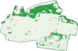
Green: 10 m cells where trees dominate, satellite 2021. Blue: water. The line is the suburb boundary.
| Canopy share, 1 m canopy height map, 2020 | 9.4% |
|---|---|
| Surveyed canopy, Greater Sydney aerial survey, 2019 | 7.5% |
| Land with trees, 10 m satellite map, 2021 | 18.2% |
Demographics
Unemployment 7.3% · Labour-force participation 44.9%
Population by age in Wetherill Park
| 0-4 | 329 |
|---|---|
| 5-14 | 846 |
| 15-19 | 373 |
| 20-24 | 364 |
| 25-34 | 826 |
| 35-44 | 753 |
| 45-54 | 758 |
| 55-64 | 851 |
| 65-74 | 826 |
| 75-84 | 365 |
| 85+ | 117 |
Dwelling types in Wetherill Park
| House | 1,744 |
|---|---|
| Townhouse | 182 |
| Apartment | 35 |
| Other | 0 |
Households by weekly income in Wetherill Park
| <$650 | 305 |
|---|---|
| $650-1,499 | 595 |
| $1,500-2,999 | 552 |
| $3,000+ | 395 |
Top ancestries in Wetherill Park
| Other | 2,893 |
|---|---|
| Australian | 708 |
| Italian | 605 |
| English | 558 |
| Chinese | 360 |
| Vietnamese | 285 |
Housing tenure in Wetherill Park
| Owned | 821 |
|---|---|
| Mortgage | 579 |
| Rented | 508 |
| Other | 34 |
Cars per household in Wetherill Park
| 0 | 92 |
|---|---|
| 1 | 611 |
| 2 | 758 |
| 3 | 304 |
| 4+ | 175 |
Commute to work in Wetherill Park
| Car | 1,086 |
|---|---|
| Train | 16 |
| Bus | 11 |
| Tram/ferry | 0 |
| Walked | 34 |
| Bicycle | 3 |
| Home | 585 |
Top countries of birth in Wetherill Park
| Iraq | 1,155 |
|---|---|
| Vietnam | 207 |
| Italy | 192 |
| Croatia | 104 |
| Philippines | 94 |
| Lebanon | 90 |
Languages used at home in Wetherill Park
| Arabic | 794 |
|---|---|
| Spanish | 318 |
| Vietnamese | 249 |
| Italian | 235 |
| Croatian | 153 |
| Macedonian | 133 |
Birds & Wildlife Nearby
16,829 bird observations recorded near Wetherill Park — most often seen:
- Rainbow Lorikeet (1,380)
- Australian Magpie (1,170)
- Noisy Miner (1,118)
- Superb Fairy-wren (868)
- Australian White Ibis (845)
- Common Myna (841)
- Australian Raven (781)
- Silvereye (684)
- Magpie-lark (596)
- Crested Pigeon (513)
- Australian Wood Duck (502)
- Pacific Black Duck (499)
- Red-whiskered Bulbul (496)
Show all 30 birds recorded near Wetherill Park
- Sulphur-crested Cockatoo (486)
- Willie Wagtail (486)
- Galah (454)
- Red-browed Finch (454)
- Dusky Moorhen (438)
- Grey Butcherbird (412)
- Pied Currawong (409)
- Welcome Swallow (390)
- Red Wattlebird (355)
- Masked Lapwing (349)
- Bell Miner (342)
- Spotted Turtle-dove (338)
- Common Starling (336)
- Rock Dove (331)
- Grey Fantail (326)
- White-faced Heron (318)
- Australasian Purple Swamphen (312)
Sightings reported by observers, not a survey, so the counts show what people record rather than what lives here. Source: Atlas of Living Australia.
Nearby Suburbs
The closest suburbs to Wetherill Park:
- Prairiewood (1.5 km)
- Bossley Park (2.2 km)
- Wakeley (2.9 km)
- Greenfield Park (3 km)
- Fairfield West (3 km)
- Smithfield (3.1 km)
- St Johns Park (3.8 km)
- Fairfield Heights (4 km)
Embed this suburb
Add this free Wetherill Park stat card to your own site — just copy the code:
Preview:
Cite this page
Quoting these figures? Copy the credit line:
Keep an eye on Wetherill Park
One email when this data meaningfully changes — new census figures, prices, rankings. No spam, unsubscribe anytime.
Streets
- Addison Street (27)
- Ainsworth Crescent (126)
- Allen Place (22)
- Arnold Street (14)
- Arnott Place (23)
- Austen Close (31)
- Belloc Close (7)
- Bentley Street (50)
- Binyon Close (19)
- Blackfriar Place (20)
- Blackmore Place (8)
- Blackstone Street (15)
- Blake Close (5)
- Blue Place (8)
- Bond Crescent (23)
- Bowie Place (7)
- Bronte Close (8)
- Browning Close (14)
- Buchan Place (7)
- Bunyan Street (2)
- Burilda Close (5)
- Bushells Place (16)
- Campion Street (23)
- Canley Vale Road (70)
- Carroll Street (9)
- Cavasinni Place (14)
- Centre Place (17)
- Century Place (2)
- Chandos Road (3)
- Chaucer Street (49)
- Chifley Street (69)
- Coates Place (9)
- Cobbett Street (110)
- Coleridge Road (28)
- Conrad Street (34)
- Cowpasture Place (50)
- Cowpasture Road (60)
- Cowper Place (21)
- Crane Place (18)
- Daniel Street (108)
- Davis Road (94)
- Defoe Place (18)
- Denoci Close (5)
- Dickens Road (39)
- Doyle Close (8)
- Dryden Place (17)
- Du Maurier Place (43)
- Durian Place (43)
- Elizabeth Street (187)
- Emerson Street (30)
- Enterprise Place (21)
- Evelyn Close (12)
- Fielding Close (13)
- Forsyth Close (6)
- Frank Street (39)
- Frost Court (13)
- Galton Street (58)
- Gissing Street (16)
- Gogol Place (15)
- Goldsmith Close (14)
- Gower Close (7)
- Gray Place (46)
- Hallstrom Place (56)
- Hargraves Place (62)
- Hassall Street (203)
- Haywood Close (52)
- Herrick Street (16)
- Hexham Place (9)
- Homer Place (15)
- Hood Close (7)
- Hopkins Street (27)
- Housman Street (28)
- Huxley Place (9)
- Ibsen Place (16)
- Keats Close (12)
- Kellaway Place (20)
- Kipling Road (9)
- Kyd Place (7)
- Lagana Place (23)
- Lamb Close (7)
- Langland Street (24)
- Lennox Place (21)
- Lily Street (60)
- Locke Street (37)
- Lodge Place (8)
- Longfellow Street (41)
- Macaulay Street (33)
- Malory Close (16)
- Mansfield Street (20)
- Marlowe Street (25)
- Marvell Road (39)
- Mary Street (15)
- Maugham Crescent (30)
- Mcilwraith Street (24)
- Mckay Close (9)
- Metters Place (17)
- Milne Close (13)
- Milton Close (14)
- Mimosa Road (1)
- Moriarty Close (5)
- Muir Place (19)
- Nello Place (35)
- Newbolt Street (22)
- Newmen Close (19)
- Newton Road (338)
- Ormsby Place (31)
- Otway Close (11)
- Plato Place (15)
- Potter Close (17)
- Price Street (19)
- Redfern Street (96)
- Rennie Street (20)
- Ross Place (6)
- Rossetti Street (27)
- Rowe Close (5)
- Ruskin Close (7)
- Shakespeare Street (100)
- Shelley Place (30)
- Sleigh Place (29)
- Stevenson Street (48)
- Swift Place (6)
- Swinborne Crescent (33)
- Tennyson Street (25)
- Thackeray Close (19)
- The Horsley Drive (484)
- Thompson Street (32)
- Tolmer Street (16)
- Toohey Road (79)
- Trivet Street (16)
- Verrell Street (30)
- Vicars Place (20)
- Victoria Street (389)
- Vidal Street (73)
- Walker Place (18)
- Walpole Close (15)
- Walter Street (4)
- Wenban Place (17)
- Wetherill Street (4)
- Widemere Road (24)
- Wordsworth Street (25)
- Wyatt Close (12)
- Yeats Street (17)