Wakeley NSW 2176
1,701 addresses · 69 streets
Fowler Electorate › Fairfield LGA › Wakeley · 28 km from Sydney
📦 Thinking of moving here? Read the Wakeley moving guide

Living Here
Wakeley is a suburb of New South Wales, home to about 4,893 people, with a median age of 41. The typical household earns around $1,553 a week, with median rent near $450 a week. Most homes are houses. About 74% of households own their home and 25% rent. Most workers drive to work. Common community backgrounds include Vietnamese, Chinese, Australian. On the ABS socio-economic scale it sits in decile 2 of 10 nationally — a more disadvantaged area.
Over time — Census 2001 → 2021
Dashed line: district figures for the St Johns Park - Wakeley statistical area (SA2), the smallest area the ABS published before 2011. Solid line: Wakeley itself.
Getting Around & Local Services
2 childcare & kindergartens
2 bakeries
2 electricians
Getting around. Train station: Canley Vale, 3.5 km south-east · Airport: Bankstown Airport, 9.6 km south-east.
Socio-economic Standing
Deciles from 1 (lowest) to 10 (highest), against all Australian suburbs. The overall figure weighs advantage and disadvantage together; economic resources counts income and housing, and education & jobs counts qualifications and occupation. They often differ. Source: ABS SEIFA 2021.
Tree cover
🌳 Tree canopy: 5.6% share of land under canopy · satellite map, 2020
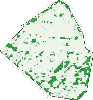
Green: 10 m cells where trees dominate, satellite 2021. Blue: water. The line is the suburb boundary.
| Canopy share, 1 m canopy height map, 2020 | 5.6% |
|---|---|
| Surveyed canopy, Greater Sydney aerial survey, 2019 | 7.4% |
| Land with trees, 10 m satellite map, 2021 | 10.7% |
Demographics
Unemployment 7.5% · Labour-force participation 42.5%
Population by age in Wakeley
| 0-4 | 235 |
|---|---|
| 5-14 | 599 |
| 15-19 | 338 |
| 20-24 | 295 |
| 25-34 | 606 |
| 35-44 | 592 |
| 45-54 | 596 |
| 55-64 | 666 |
| 65-74 | 587 |
| 75-84 | 297 |
| 85+ | 84 |
Dwelling types in Wakeley
| House | 1,251 |
|---|---|
| Townhouse | 190 |
| Apartment | 19 |
| Other | 0 |
Households by weekly income in Wakeley
| <$650 | 217 |
|---|---|
| $650-1,499 | 444 |
| $1,500-2,999 | 424 |
| $3,000+ | 286 |
Top ancestries in Wakeley
| Other | 2,101 |
|---|---|
| Vietnamese | 860 |
| Chinese | 643 |
| Australian | 400 |
| Ancestry NS | 283 |
| English | 267 |
Housing tenure in Wakeley
| Owned | 596 |
|---|---|
| Mortgage | 459 |
| Rented | 353 |
| Other | 17 |
Cars per household in Wakeley
| 0 | 80 |
|---|---|
| 1 | 448 |
| 2 | 544 |
| 3 | 238 |
| 4+ | 135 |
Commute to work in Wakeley
| Car | 809 |
|---|---|
| Train | 12 |
| Bus | 11 |
| Tram/ferry | 0 |
| Walked | 13 |
| Bicycle | 0 |
| Home | 437 |
Top countries of birth in Wakeley
| Iraq | 782 |
|---|---|
| Vietnam | 683 |
| Cambodia | 207 |
| Croatia | 78 |
| Chile | 64 |
| North Macedonia | 54 |
Languages used at home in Wakeley
| Vietnamese | 877 |
|---|---|
| Arabic | 349 |
| Khmer | 193 |
| Spanish | 162 |
| Cantonese | 160 |
| Croatian | 129 |
Birds & Wildlife Nearby
24,186 bird observations recorded near Wakeley — most often seen:
- Rainbow Lorikeet (1,795)
- Australian Magpie (1,646)
- Noisy Miner (1,479)
- Australian White Ibis (1,374)
- Common Myna (1,186)
- Australian Raven (1,119)
- Magpie-lark (981)
- Sulphur-crested Cockatoo (917)
- Willie Wagtail (859)
- Rock Dove (826)
- Superb Fairy-wren (802)
- Dusky Moorhen (791)
- Spotted Turtle-dove (788)
Show all 30 birds recorded near Wakeley
- Pacific Black Duck (774)
- Crested Pigeon (744)
- Common Starling (706)
- Pied Currawong (689)
- Australian Wood Duck (683)
- Welcome Swallow (674)
- Grey Butcherbird (653)
- Red Wattlebird (606)
- Red-whiskered Bulbul (591)
- Masked Lapwing (521)
- Galah (509)
- Black-faced Cuckoo-shrike (455)
- Bell Miner (428)
- Eurasian Blackbird (403)
- House Sparrow (397)
- New Holland Honeyeater (397)
- Birds (393)
Sightings reported by observers, not a survey, so the counts show what people record rather than what lives here. Source: Atlas of Living Australia.
Nearby Suburbs
The closest suburbs to Wakeley:
- St Johns Park (1.2 km)
- Prairiewood (1.3 km)
- Greenfield Park (1.6 km)
- Fairfield West (1.6 km)
- Canley Heights (1.8 km)
- Cabramatta West (2.1 km)
- Bonnyrigg (2.7 km)
- Bossley Park (2.7 km)
Embed this suburb
Add this free Wakeley stat card to your own site — just copy the code:
Preview:
Cite this page
Quoting these figures? Copy the credit line:
Keep an eye on Wakeley
One email when this data meaningfully changes — new census figures, prices, rankings. No spam, unsubscribe anytime.
Streets
- Adelong Close (20)
- Albany Close (19)
- Avoca Road (59)
- Bathurst Street (51)
- Bendigo Close (12)
- Box Road (56)
- Brockman Street (25)
- Bulls Road (121)
- Bunya Place (3)
- Burns Road (55)
- Cairns Place (8)
- Canley Vale Road (5)
- Carnarvon Street (3)
- Chapman Place (8)
- Cloncurry Place (15)
- Cobar Close (10)
- Corriedale Street (65)
- Darwin Close (22)
- Devonport Street (22)
- Dorset Close (38)
- Dundas Place (17)
- Esmond Place (20)
- Esperance Crescent (23)
- Fremantle Place (19)
- Goulburn Place (32)
- Gundagai Crescent (32)
- Gympie Place (9)
- Hampshire Place (17)
- Hay Place (6)
- Hillend Place (16)
- Hobart Place (3)
- Hook Place (10)
- Humphries Road (66)
- Iluka Close (6)
- Innisfail Road (60)
- Kembla Street (36)
- Kiandra Place (21)
- Kilcarn Place (11)
- King Road (1)
- Leicester Street (21)
- Lomond Street (26)
- Mallacoota Street (135)
- Marsh Street (15)
- Mcbrian Place (4)
- Mcpherson Street (16)
- Meroo Close (10)
- Molluso Close (10)
- Morton Close (13)
- Murrumburrah Street (38)
- Newcastle Street (39)
- Pessotto Place (10)
- Pirie Close (27)
- Richards Road (58)
- Rogan Crescent (2)
- Romney Place (11)
- Ryland Close (9)
- Shoalhaven Street (38)
- Shropshire Close (20)
- Smithfield Road (4)
- Strzelecki Close (18)
- Tanami Close (10)
- Townsville Road (8)
- Warren Place (7)
- Welcome Street (8)
- Wellington Street (17)
- Whyalla Close (18)
- Winburndale Road (59)
- Wyalong Close (16)
- Zenith Close (12)