West Albury NSW 2640
2,171 addresses · 97 streets
Farrer Electorate › Albury LGA › West Albury · 464 km from Sydney
📦 Thinking of moving here? Read the West Albury moving guide

Living Here
West Albury is a suburb of New South Wales, home to about 3,872 people, with a median age of 46. The typical household earns around $1,363 a week, with median rent near $255 a week. Most homes are houses. About 67% of households own their home and 30% rent. Most workers drive to work. Common community backgrounds include English, Australian, Irish. On the ABS socio-economic scale it sits in decile 4 of 10 nationally — a mid-range area.
Over time — Census 2001 → 2021
Dashed line: district figures for the Albury - South statistical area (SA2), the smallest area the ABS published before 2011. Solid line: West Albury itself.
Getting Around & Local Services
3 supermarkets
1 medical clinic
1 physiotherapist
1 optometrist
2 childcare & kindergartens
4 service stations
2 golf clubs
3 hardware stores
1 hairdresser
3 mechanics
Getting around. Train station: Albury, 3.1 km east · Bus interchange: Albury Station, 3.1 km east · Airport: Albury Airport, 6.1 km east.
Socio-economic Standing
Deciles from 1 (lowest) to 10 (highest), against all Australian suburbs. The overall figure weighs advantage and disadvantage together; economic resources counts income and housing, and education & jobs counts qualifications and occupation. They often differ. Source: ABS SEIFA 2021.
Tree cover
🌳 Tree canopy: 41.9% share of land under canopy · satellite map, 2020
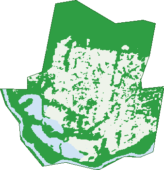
Green: 10 m cells where trees dominate, satellite 2021. Blue: water. The line is the suburb boundary.
| Canopy share, 1 m canopy height map, 2020 | 41.9% |
|---|---|
| Land with trees, 10 m satellite map, 2021 | 56.5% |
Demographics
Unemployment 5.7% · Labour-force participation 53.5%
Population by age in West Albury
| 0-4 | 211 |
|---|---|
| 5-14 | 438 |
| 15-19 | 206 |
| 20-24 | 183 |
| 25-34 | 411 |
| 35-44 | 424 |
| 45-54 | 398 |
| 55-64 | 559 |
| 65-74 | 473 |
| 75-84 | 336 |
| 85+ | 233 |
Dwelling types in West Albury
| House | 1,233 |
|---|---|
| Townhouse | 319 |
| Apartment | 0 |
| Other | 0 |
Households by weekly income in West Albury
| <$650 | 307 |
|---|---|
| $650-1,499 | 496 |
| $1,500-2,999 | 417 |
| $3,000+ | 245 |
Top ancestries in West Albury
| English | 1,558 |
|---|---|
| Australian | 1,416 |
| Irish | 521 |
| Scottish | 425 |
| German | 283 |
| Ancestry NS | 274 |
Housing tenure in West Albury
| Owned | 617 |
|---|---|
| Mortgage | 404 |
| Rented | 464 |
| Other | 47 |
Cars per household in West Albury
| 0 | 100 |
|---|---|
| 1 | 665 |
| 2 | 538 |
| 3 | 162 |
| 4+ | 71 |
Commute to work in West Albury
| Car | 1,241 |
|---|---|
| Train | 0 |
| Bus | 5 |
| Tram/ferry | 0 |
| Walked | 27 |
| Bicycle | 11 |
| Home | 171 |
Top countries of birth in West Albury
| England | 93 |
|---|---|
| India | 45 |
| New Zealand | 42 |
| South Africa | 33 |
| Philippines | 25 |
| Germany | 17 |
Languages used at home in West Albury
| Tagalog | 19 |
|---|---|
| Greek | 16 |
| Malayalam | 16 |
| Nepali | 14 |
| Hindi | 13 |
| French | 12 |
Birds & Wildlife Nearby
64,356 bird observations recorded near West Albury — most often seen:
- Pacific Black Duck (3,351)
- Australian Magpie (3,328)
- Australian White Ibis (3,077)
- Magpie-lark (2,873)
- Australian Wood Duck (2,702)
- Dusky Moorhen (2,549)
- Superb Fairy-wren (2,443)
- White-plumed Honeyeater (2,380)
- Grey Teal (2,277)
- Galah (2,219)
- Eurasian Coot (2,185)
- Australasian Purple Swamphen (2,167)
- Australian Raven (2,136)
Show all 30 birds recorded near West Albury
- White-faced Heron (2,103)
- Welcome Swallow (2,042)
- Sulphur-crested Cockatoo (1,996)
- Eurasian Blackbird (1,987)
- Whistling Kite (1,951)
- Common Starling (1,932)
- Willie Wagtail (1,929)
- Little Pied Cormorant (1,882)
- Pied Currawong (1,865)
- Laughing Kookaburra (1,802)
- Black Swan (1,744)
- Little Black Cormorant (1,721)
- Australian Pelican (1,689)
- Red-browed Finch (1,532)
- Masked Lapwing (1,521)
- Red-rumped Parrot (1,521)
- Great Egret (1,452)
Sightings reported by observers, not a survey, so the counts show what people record rather than what lives here. Source: Atlas of Living Australia.
Nearby Suburbs
The closest suburbs to West Albury:
- Albury (2.2 km)
- South Albury (2.8 km)
- Glenroy (3 km)
- North Albury (4 km)
- East Albury (4.2 km)
- Hamilton Valley (5 km)
- Splitters Creek (5.2 km)
- Lavington (5.6 km)
Embed this suburb
Add this free West Albury stat card to your own site — just copy the code:
Preview:
Cite this page
Quoting these figures? Copy the credit line:
Keep an eye on West Albury
One email when this data meaningfully changes — new census figures, prices, rankings. No spam, unsubscribe anytime.
Streets
- Acacia Place (7)
- Amber Court (6)
- Astvale Court (6)
- Baker Court (12)
- Balu Court (12)
- Banksia Street (27)
- Baranduda View (6)
- Benn Crescent (23)
- Blackmore Street (28)
- Briggs Court (8)
- Briwood Court (21)
- Brookside Court (7)
- Cameron Court (10)
- Carbine Court (9)
- Cassia Street (22)
- Chatterton Place (15)
- Chelsea Court (13)
- Clinton Avenue (26)
- Cyprus Place (8)
- Day Street (21)
- Doland Street (23)
- Doongan Place (20)
- Doulton Drive (17)
- Elmglade Close (32)
- Emerson Street (21)
- Fern Place (9)
- Florence Crescent (31)
- Gemstone Place (5)
- Glendale Avenue (10)
- Glenwood Court (6)
- Gould Avenue (26)
- Greentree Way (31)
- Grevillea Place (7)
- Gulson Street (6)
- Hakea Place (10)
- Heather Court (15)
- Hibiscus Crescent (31)
- Highgrove Place (15)
- Hill Street (65)
- Hugh Court (9)
- Hurworth Court (14)
- Jacaranda Street (55)
- Johnston Road (49)
- Kingsley Court (11)
- Klinberg Court (16)
- Klinberg Road (15)
- Kremur Street (9)
- Kurrajong Crescent (52)
- Lamport Crescent (30)
- Maple Place (8)
- Mayfair Court (10)
- Maynet Place (7)
- Mclennan Street (45)
- Mcleod Court (24)
- Meadow Grove Close (14)
- Memorial Drive (1)
- Miller Street (38)
- Mott Street (54)
- Mulga Place (15)
- Myrtle Street (12)
- Nicholson Place (21)
- Northern View Drive (22)
- O'brien Court (22)
- Oakwood Court (6)
- Padman Drive (152)
- Park Lane (5)
- Pemberton Street (86)
- Prujoy Place (16)
- Quarry Street (3)
- Quinton Court (17)
- Ramsay Place (11)
- Ringwood Crescent (37)
- Riverwood Drive (16)
- Roper Place (5)
- Roper Street (18)
- Rosedale Drive (44)
- Solomon Street (57)
- Somerset Drive (41)
- Southern View Court (8)
- Southern View Drive (62)
- Spring Rise (8)
- Springfield Court (8)
- Spurrway Drive (26)
- Stafford Road (16)
- Sturtvale Court (17)
- Sunset Drive (39)
- Sylvan Court (2)
- Thorold Street (46)
- Valley View Court (9)
- Valley View Drive (20)
- Waratah Crescent (41)
- Warrenlee Drive (44)
- Wattle Way (21)
- Western View Drive (33)
- Willowglen Court (9)
- Woodland Close (18)
- Yalandra Court (10)