Lavington NSW 2641
8,866 addresses · 243 streets
Farrer Electorate › Albury LGA › Lavington · 458 km from Sydney
📦 Thinking of moving here? Read the Lavington moving guide

Living Here
A large residential suburb of Albury on the NSW-Victoria border, Lavington is affordable and family-oriented. Households average 2.2 people and the median age is 40. Median household income is $1,130 a week, with rent around $250.
Lavington is a suburb of New South Wales, home to about 13,073 people, with a median age of 40. The typical household earns around $1,130 a week, with median rent near $250 a week. Most homes are houses. About 58% of households own their home and 40% rent. Most workers drive to work. Common community backgrounds include Australian, English, Irish. On the ABS socio-economic scale it sits in decile 1 of 10 nationally — a more disadvantaged area.
Over time — Census 2001 → 2021
Dashed line: district figures for the Lavington statistical area (SA2), the smallest area the ABS published before 2011. Solid line: Lavington itself.
Getting Around & Local Services
2 Catholic churches
1 pharmacy
2 doctors & medical clinics
1 physiotherapist
2 childcare & kindergartens
2 libraries
2 post offices
8 service stations
2 golf clubs
1 bakery
1 butcher
3 hardware stores
3 hairdressers
2 beauty salons
1 mechanic
Getting around. Train station: Albury, 4.8 km south · Bus interchange: Albury Station, 4.9 km south · Airport: Albury Airport, 3.4 km south-east.
Socio-economic Standing
Deciles from 1 (lowest) to 10 (highest), against all Australian suburbs. The overall figure weighs advantage and disadvantage together; economic resources counts income and housing, and education & jobs counts qualifications and occupation. They often differ. Source: ABS SEIFA 2021.
Tree cover
🌳 Tree canopy: 24.3% share of land under canopy · satellite map, 2020
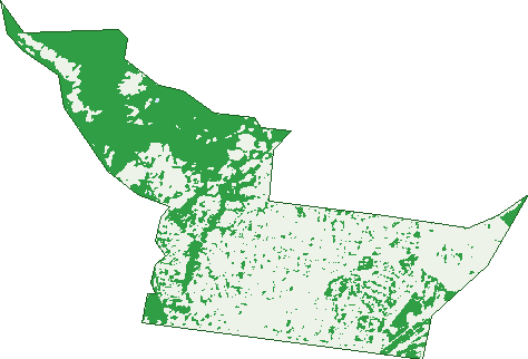
Green: 10 m cells where trees dominate, satellite 2021. Blue: water. The line is the suburb boundary.
| Canopy share, 1 m canopy height map, 2020 | 24.3% |
|---|---|
| Land with trees, 10 m satellite map, 2021 | 38.4% |
Demographics
Unemployment 6.5% · Labour-force participation 54.9%
Population by age in Lavington
| 0-4 | 793 |
|---|---|
| 5-14 | 1,491 |
| 15-19 | 733 |
| 20-24 | 890 |
| 25-34 | 1,766 |
| 35-44 | 1,506 |
| 45-54 | 1,430 |
| 55-64 | 1,579 |
| 65-74 | 1,588 |
| 75-84 | 937 |
| 85+ | 344 |
Dwelling types in Lavington
| House | 4,131 |
|---|---|
| Townhouse | 1,209 |
| Apartment | 87 |
| Other | 25 |
Households by weekly income in Lavington
| <$650 | 1,326 |
|---|---|
| $650-1,499 | 1,895 |
| $1,500-2,999 | 1,445 |
| $3,000+ | 401 |
Top ancestries in Lavington
| Australian | 4,883 |
|---|---|
| English | 4,838 |
| Irish | 1,477 |
| Other | 1,444 |
| Scottish | 1,165 |
| German | 970 |
Housing tenure in Lavington
| Owned | 1,630 |
|---|---|
| Mortgage | 1,456 |
| Rented | 2,154 |
| Other | 98 |
Cars per household in Lavington
| 0 | 505 |
|---|---|
| 1 | 2,356 |
| 2 | 1,672 |
| 3 | 523 |
| 4+ | 286 |
Commute to work in Lavington
| Car | 4,328 |
|---|---|
| Train | 4 |
| Bus | 41 |
| Tram/ferry | 3 |
| Walked | 106 |
| Bicycle | 36 |
| Home | 335 |
Top countries of birth in Lavington
| India | 371 |
|---|---|
| England | 206 |
| Nepal | 170 |
| New Zealand | 138 |
| Philippines | 122 |
| Germany | 73 |
Languages used at home in Lavington
| Nepali | 375 |
|---|---|
| Punjabi | 307 |
| Tagalog | 64 |
| Hindi | 55 |
| Bengali | 48 |
| Mandarin | 38 |
Birds & Wildlife Nearby
21,327 bird observations recorded near Lavington — most often seen:
- Australian Magpie (1,819)
- Galah (1,300)
- Pied Currawong (1,181)
- Eurasian Blackbird (1,091)
- Magpie-lark (1,024)
- Red Wattlebird (888)
- Common Starling (867)
- Noisy Miner (857)
- Crested Pigeon (788)
- Australian Wood Duck (786)
- Pacific Black Duck (752)
- Australian White Ibis (725)
- Australian Raven (711)
Show all 30 birds recorded near Lavington
- Rainbow Lorikeet (694)
- Eastern Rosella (691)
- Spotted Turtle-dove (610)
- House Sparrow (587)
- Superb Fairy-wren (579)
- Laughing Kookaburra (567)
- Eastern Australian Magpie (524)
- Welcome Swallow (487)
- Willie Wagtail (481)
- Red-rumped Parrot (458)
- Masked Lapwing (448)
- Silvereye (438)
- Blue-faced Honeyeater (419)
- Eastern Red Wattlebird (408)
- Australasian Grebe (392)
- White-plumed Honeyeater (380)
- Dusky Moorhen (375)
Sightings reported by observers, not a survey, so the counts show what people record rather than what lives here. Source: Atlas of Living Australia.
Nearby Suburbs
The closest suburbs to Lavington:
- Springdale Heights (1.7 km)
- North Albury (2 km)
- Glenroy (2.8 km)
- Hamilton Valley (2.8 km)
- East Albury (4.3 km)
- Albury (4.4 km)
- Ettamogah (4.5 km)
- Thurgoona (4.8 km)
Embed this suburb
Add this free Lavington stat card to your own site — just copy the code:
Preview:
Cite this page
Quoting these figures? Copy the credit line:
Keep an eye on Lavington
One email when this data meaningfully changes — new census figures, prices, rankings. No spam, unsubscribe anytime.
Streets
- Abbott Drive (15)
- Ainslie Avenue (52)
- Albert Street (6)
- Alldis Avenue (103)
- Amalfi Drive (42)
- Annette Court (27)
- Annette Crescent (27)
- Apricot Lane (1)
- Ashford Street (71)
- Balkston Street (1)
- Balmain Place (9)
- Balston Street (26)
- Barlow Street (7)
- Baxter Court (20)
- Bell Street (23)
- Bernley Court (14)
- Bevan Street (85)
- Bevington Bend (34)
- Bindi Court (4)
- Bishop Street (8)
- Bonnie Doon Court (15)
- Boomerang Drive (26)
- Bownds Street (50)
- Breen Street (66)
- Brent Court (32)
- Briardale Road (19)
- Brookfields Mews (22)
- Brown Place (6)
- Brown Street (10)
- Bruno Place (14)
- Buchhorn Street (29)
- Bundarra Place (5)
- Burrows Road (6)
- Cambourne Street (61)
- Carlma Crescent (9)
- Carstens Street (19)
- Catherine Crescent (174)
- Centaur Road (28)
- Chant Street (32)
- Cheyenne Drive (59)
- Chloe Court (7)
- Christopher Court (15)
- Clarence Street (18)
- Cobby Court (12)
- Colleen Place (6)
- Colley Street (43)
- Comans Avenue (37)
- Condon Place (37)
- Conrad Place (17)
- Creekside Court (9)
- Creighton Court (12)
- Dale Crescent (63)
- Dallinger Road (81)
- Daly Street (42)
- Danes Street (65)
- Darke Street (14)
- Davern Place (5)
- Desmond Street (54)
- Dick Road (112)
- Diggers Road (37)
- Ditmann Place (11)
- Donald Court (4)
- Donnolley Court (32)
- Douglas Road (202)
- Eden Street (72)
- Ellora Court (14)
- Elton Court (20)
- English Avenue (47)
- Eyre Court (7)
- Fox Street (2)
- Gabrielle Court (24)
- Gayview Crescent (11)
- Glendaloch Court (30)
- Graetz Court (26)
- Grammar Drive (12)
- Grayfern Court (31)
- Griffith Road (347)
- Hague Street (159)
- Haines Court (13)
- Halehaven Crescent (24)
- Hall Avenue (29)
- Hamilton Valley Court (23)
- Harper Street (4)
- Hartley Street (29)
- Haven Place (12)
- Hawkins Court (6)
- Hazel Court (14)
- Hazeldene Court (5)
- Hazeldene Place (4)
- Heathwood Avenue (40)
- Hedley Crescent (14)
- Henderson Street (31)
- Heriot Street (31)
- Hickey Lane (5)
- Highview Crescent (45)
- Hudson Crescent (11)
- Iluka Crescent (51)
- Indiana Court (9)
- Jacinta Court (9)
- Jackling Drive (43)
- Janette Court (21)
- Jason Court (17)
- Jennifer Street (2)
- Jorma Place (11)
- Joyce Place (8)
- Julie Place (23)
- June Court (12)
- Kaitlers Road (146)
- Kalimna Crescent (12)
- Kambora Court (34)
- Karl Court (8)
- Karoola Place (6)
- Kaylock Road (37)
- Keatinge Court (30)
- Kemp Street (132)
- Kentucky Avenue (26)
- Kimberley Court (29)
- Klose Street (59)
- Kotthoff Street (197)
- Krautz Street (17)
- Kunama Court (7)
- La Fontaine Avenue (49)
- Laramee Drive (21)
- Lawson Circuit (49)
- Lea Court (14)
- Leonie Court (11)
- Livermore Street (23)
- Livingstone Court (10)
- Lucinda Court (6)
- Lyne Street (103)
- Macarthur Street (28)
- Mair Street (30)
- Manjula Court (20)
- Manns Street (11)
- Margaret Place (58)
- Marian Way (5)
- Mark Crescent (16)
- Marshall Street (26)
- Martha Mews (50)
- Mary Court (4)
- Mcdonald Road (190)
- Mckenzie Street (56)
- Mcmaster Avenue (35)
- Meera Court (20)
- Michelle Avenue (52)
- Miles Street (3)
- Mitta Grove (16)
- Moffat Street (24)
- Moore Street (181)
- Mountain View Drive (40)
- Mountain Way (24)
- Mulberry Court (15)
- Murphy Street (14)
- Mutsch Street (33)
- Nabowla Court (4)
- Nagle Road (63)
- Neptune Drive (27)
- Neville Street (17)
- Newman Nook (2)
- Nicola Place (26)
- Noorla Place (20)
- Norris Street (8)
- Nowland Avenue (22)
- O'mahony Close (3)
- O'shea Street (18)
- Oliver Street (36)
- Orchard Way (30)
- Osborne Street (10)
- Owen Court (24)
- Oxley Way (8)
- Palcas Court (4)
- Panorama Place (15)
- Parkland Crescent (50)
- Parkview Crescent (16)
- Parnall Street (137)
- Paul Avenue (19)
- Payerl Court (15)
- Pearsall Street (61)
- Pigram Street (5)
- Pine Avenue (5)
- Poplar Drive (24)
- Privett Place (29)
- Prune Street (297)
- Rachel Court (48)
- Red Hill Court (8)
- Reid Avenue (31)
- Reiff Street (8)
- Renwick Court (19)
- Reservoir Road (40)
- Roach Street (22)
- Robert Court (6)
- Romani Drive (29)
- Rose Street (69)
- Ross Circuit (106)
- Rowen Court (8)
- Royce Crescent (85)
- Sanders Road (30)
- Sandrina Drive (46)
- Saville Avenue (64)
- Schaefer Street (85)
- Schneider Street (10)
- Schubach Street (1)
- Seymour Street (28)
- Shelley Avenue (13)
- Shirleen Crescent (37)
- Sioux Court (16)
- St Levans Place (32)
- Strang Place (9)
- Sunshine Court (8)
- Sunwood Drive (17)
- Sutherland Street (44)
- Syntax Circuit (11)
- Titan Court (10)
- Tracy Street (27)
- Travelstop Way (5)
- Tristan Court (14)
- Tumgarra Place (37)
- Turner Street (8)
- Twin Crescent (12)
- Union Road (154)
- Urana Road (326)
- Valerie Way (8)
- Vickers Road (76)
- Victor Place (4)
- Villawood Court (18)
- Vista Court (7)
- Wagga Road (377)
- Wahroonga Road (22)
- Waldner Court (13)
- Warren Street (33)
- Watt Place (8)
- Wattle Grove (5)
- Wattletree Road (13)
- Webb Street (101)
- Welsh Street (18)
- Wentworth Court (18)
- Wenview Place (5)
- Williams Street (17)
- Woodbury Court (27)
- Woolpoint Court (10)
- Woomera Crescent (19)
- Worsley Place (20)
- Zago Court (12)