Sanctuary Point NSW 2540
5,086 addresses · 105 streets
Gilmore Electorate › Shoalhaven LGA › Sanctuary Point · 147 km from Sydney
📦 Thinking of moving here? Read the Sanctuary Point moving guide

Living Here
Sanctuary Point is a suburb of New South Wales, home to about 7,874 people, with a median age of 47. The typical household earns around $1,068 a week, with median rent near $360 a week. Most homes are houses. About 70% of households own their home and 29% rent. Most workers drive to work. Common community backgrounds include English, Australian, Irish. On the ABS socio-economic scale it sits in decile 2 of 10 nationally — a more disadvantaged area.
Over time — Census 2001 → 2021
Dashed line: district figures for the St Georges Basin - Erowal Bay statistical area (SA2), the smallest area the ABS published before 2011. Solid line: Sanctuary Point itself.
Getting Around & Local Services
2 cafés & restaurants
1 pharmacy
1 physiotherapist
1 optometrist
1 library
1 service station
Getting around. Airport: HMAS Albatross, 19.3 km north.
Socio-economic Standing
Deciles from 1 (lowest) to 10 (highest), against all Australian suburbs. The overall figure weighs advantage and disadvantage together; economic resources counts income and housing, and education & jobs counts qualifications and occupation. They often differ. Source: ABS SEIFA 2021.
Tree cover
🌳 Tree canopy: 16.1% share of land under canopy · satellite map, 2020
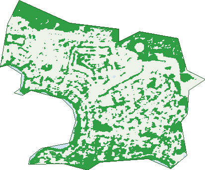
Green: 10 m cells where trees dominate, satellite 2021. Blue: water. The line is the suburb boundary.
| Canopy share, 1 m canopy height map, 2020 | 16.1% |
|---|---|
| Land with trees, 10 m satellite map, 2021 | 40.3% |
Demographics
Unemployment 6.5% · Labour-force participation 45.6%
Population by age in Sanctuary Point
| 0-4 | 418 |
|---|---|
| 5-14 | 873 |
| 15-19 | 436 |
| 20-24 | 380 |
| 25-34 | 820 |
| 35-44 | 834 |
| 45-54 | 885 |
| 55-64 | 1,101 |
| 65-74 | 1,252 |
| 75-84 | 709 |
| 85+ | 180 |
Dwelling types in Sanctuary Point
| House | 3,064 |
|---|---|
| Townhouse | 98 |
| Apartment | 55 |
| Other | 13 |
Households by weekly income in Sanctuary Point
| <$650 | 754 |
|---|---|
| $650-1,499 | 1,220 |
| $1,500-2,999 | 800 |
| $3,000+ | 200 |
Top ancestries in Sanctuary Point
| English | 3,354 |
|---|---|
| Australian | 3,295 |
| Irish | 800 |
| Scottish | 777 |
| Aboriginal | 634 |
| Ancestry NS | 506 |
Housing tenure in Sanctuary Point
| Owned | 1,349 |
|---|---|
| Mortgage | 884 |
| Rented | 909 |
| Other | 34 |
Cars per household in Sanctuary Point
| 0 | 124 |
|---|---|
| 1 | 1,379 |
| 2 | 1,144 |
| 3 | 374 |
| 4+ | 165 |
Commute to work in Sanctuary Point
| Car | 2,065 |
|---|---|
| Train | 0 |
| Bus | 4 |
| Tram/ferry | 0 |
| Walked | 29 |
| Bicycle | 8 |
| Home | 218 |
Top countries of birth in Sanctuary Point
| England | 342 |
|---|---|
| New Zealand | 91 |
| Philippines | 54 |
| Germany | 48 |
| Scotland | 43 |
| Greece | 34 |
Languages used at home in Sanctuary Point
| Greek | 58 |
|---|---|
| Spanish | 34 |
| Croatian | 30 |
| Arabic | 25 |
| German | 25 |
| Tagalog | 25 |
Birds & Wildlife Nearby
11,276 bird observations recorded near Sanctuary Point — most often seen:
- Rainbow Lorikeet (1,083)
- Laughing Kookaburra (639)
- Red Wattlebird (595)
- Crimson Rosella (541)
- Common Bronzewing (484)
- Little Wattlebird (481)
- South-eastern Glossy Black-cockatoo (478)
- Masked Lapwing (467)
- Australian Magpie (455)
- Magpie-lark (400)
- Australian King-parrot (365)
- Chestnut Teal (352)
- Eastern Spinebill (342)
Show all 30 birds recorded near Sanctuary Point
- New Holland Honeyeater (330)
- Yellow-faced Honeyeater (326)
- Australian Pelican (305)
- Pied Currawong (302)
- Australian Raven (298)
- Australian Wood Duck (297)
- Superb Fairy-wren (286)
- Grey Butcherbird (278)
- Little Pied Cormorant (278)
- Brown Thornbill (263)
- Eastern Yellow Robin (248)
- Pacific Black Duck (242)
- Sulphur-crested Cockatoo (241)
- Grey Fantail (240)
- Common Myna (223)
- Black Swan (220)
- White-faced Heron (217)
Sightings reported by observers, not a survey, so the counts show what people record rather than what lives here. Source: Atlas of Living Australia.
Nearby Suburbs
The closest suburbs to Sanctuary Point:
- Worrowing Heights (2.4 km)
- Erowal Bay (2.7 km)
- Old Erowal Bay (2.8 km)
- St Georges Basin (3 km)
- Bream Beach (3.2 km)
- Wrights Beach (3.6 km)
- Basin View (5.8 km)
- Vincentia (5.8 km)
Embed this suburb
Add this free Sanctuary Point stat card to your own site — just copy the code:
Preview:
Cite this page
Quoting these figures? Copy the credit line:
Keep an eye on Sanctuary Point
One email when this data meaningfully changes — new census figures, prices, rankings. No spam, unsubscribe anytime.
Streets
- Albion Street (17)
- Allen Street (4)
- Anabel Place (26)
- Anson Street (81)
- Attunga Avenue (10)
- Auster Crescent (30)
- Avro Avenue (19)
- Azalea Avenue (13)
- Bader Road (4)
- Ball Close (10)
- Banksia Avenue (8)
- Beaver Avenue (8)
- Belpitt Place (6)
- Boomerang Street (24)
- Boronia Avenue (33)
- Cammaray Drive (33)
- Capeland Avenue (36)
- Carmel Drive (36)
- Centaur Avenue (18)
- Cessna Avenue (36)
- Chipmunk Avenue (9)
- Clifton Street (47)
- Corella Crescent (47)
- Curlew Street (9)
- Decora Avenue (6)
- Dunisla Street (32)
- Eagle Place (7)
- Edmund Street (79)
- Emu Avenue (5)
- Endeavour Street (27)
- Ethel Street (141)
- Fairway Drive (109)
- Flamingo Avenue (61)
- Flora Street (17)
- Forrester Court (43)
- Frederick Street (197)
- Gibson Crescent (32)
- Goshawk Street (5)
- Greville Avenue (252)
- Gull Avenue (5)
- Gymea Avenue (21)
- Heron Avenue (31)
- Hewitt Avenue (7)
- Hogbin Crescent (37)
- Idlewild Avenue (62)
- Irene Street (6)
- Jean Street (3)
- Karne Street (38)
- Kean Avenue (27)
- Kenneth Avenue (31)
- Kerry Street (270)
- Kestrel Avenue (19)
- Kingfisher Avenue (25)
- Kingsford Smith Crescent (48)
- Kirkham Way (30)
- Larmer Avenue (50)
- Lawson Way (12)
- Leumeah Street (158)
- Links Avenue (109)
- Loralyn Avenue (89)
- Macleans Point Road (240)
- Marie Street (6)
- Maxwell Crescent (25)
- Milson Street (8)
- Mountain Street (36)
- Mustang Drive (125)
- Nadine Street (42)
- Nirimba Avenue (23)
- Paino Crescent (18)
- Paradise Beach Road (150)
- Pelican Street (10)
- Penguin Street (36)
- Percy Street (10)
- Piper Avenue (5)
- Platypus Avenue (7)
- Ridgelands Drive (79)
- Robinsville Place (10)
- Rose Avenue (5)
- Roulstone Crescent (57)
- Salinas Street (11)
- Sanctuary Point Road (227)
- Shoreville Place (4)
- Sirius Avenue (25)
- Stephens Road (10)
- Tahnee Street (94)
- Telopea Avenue (7)
- The Glen (12)
- The Lane (1)
- The Park Drive (351)
- The Wool Lane (8)
- The Wool Road (17)
- Truscott Avenue (25)
- Ulm Road (22)
- Unicorn Street (12)
- Vickery Avenue (45)
- Vost Drive (72)
- Wallabia Place (6)
- Walmer Avenue (262)
- Waratah Crescent (144)
- Warrego Drive (103)
- Wattle Avenue (17)
- Waxberry Place (13)
- Wool Lane (18)
- Wullun Close (16)
- Yallara Crescent (17)