Vincentia NSW 2540
3,385 addresses · 93 streets
Gilmore Electorate › Shoalhaven LGA › Vincentia · 142 km from Sydney
📦 Thinking of moving here? Read the Vincentia moving guide

Living Here
Vincentia is a suburb of New South Wales, home to about 3,870 people, with a median age of 50. The typical household earns around $1,550 a week, with median rent near $425 a week. Most homes are houses. About 75% of households own their home and 24% rent. Most workers drive to work. Common community backgrounds include English, Australian, Irish. On the ABS socio-economic scale it sits in decile 9 of 10 nationally — a relatively advantaged area.
Over time — Census 2001 → 2021
Dashed line: district figures for the Huskisson - Vincentia statistical area (SA2), the smallest area the ABS published before 2011. Solid line: Vincentia itself.
Getting Around & Local Services
3 supermarkets
2 pharmacies
2 doctors & medical clinics
1 dentist
1 optometrist
1 library
2 post offices
2 service stations
1 gym
2 bakeries
2 butchers
3 hairdressers
1 beauty salon
2 mechanics
Getting around. Ferry wharf: Husky Ferry, 3.7 km north · Airport: HMAS Albatross, 18.5 km north-west.
Socio-economic Standing
Deciles from 1 (lowest) to 10 (highest), against all Australian suburbs. The overall figure weighs advantage and disadvantage together; economic resources counts income and housing, and education & jobs counts qualifications and occupation. They often differ. Source: ABS SEIFA 2021.
Tree cover
🌳 Tree canopy: 44.7% share of land under canopy · satellite map, 2020
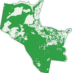
Green: 10 m cells where trees dominate, satellite 2021. Blue: water. The line is the suburb boundary.
| Canopy share, 1 m canopy height map, 2020 | 44.7% |
|---|---|
| Land with trees, 10 m satellite map, 2021 | 70.5% |
Demographics
Unemployment 3.5% · Labour-force participation 52.1%
Population by age in Vincentia
| 0-4 | 180 |
|---|---|
| 5-14 | 413 |
| 15-19 | 155 |
| 20-24 | 127 |
| 25-34 | 367 |
| 35-44 | 448 |
| 45-54 | 464 |
| 55-64 | 603 |
| 65-74 | 696 |
| 75-84 | 304 |
| 85+ | 116 |
Dwelling types in Vincentia
| House | 1,457 |
|---|---|
| Townhouse | 60 |
| Apartment | 73 |
| Other | 0 |
Households by weekly income in Vincentia
| <$650 | 241 |
|---|---|
| $650-1,499 | 493 |
| $1,500-2,999 | 470 |
| $3,000+ | 309 |
Top ancestries in Vincentia
| English | 1,677 |
|---|---|
| Australian | 1,443 |
| Irish | 481 |
| Scottish | 476 |
| Other | 295 |
| Ancestry NS | 167 |
Housing tenure in Vincentia
| Owned | 769 |
|---|---|
| Mortgage | 422 |
| Rented | 379 |
| Other | 15 |
Cars per household in Vincentia
| 0 | 55 |
|---|---|
| 1 | 563 |
| 2 | 697 |
| 3 | 183 |
| 4+ | 90 |
Commute to work in Vincentia
| Car | 1,074 |
|---|---|
| Train | 0 |
| Bus | 4 |
| Tram/ferry | 0 |
| Walked | 49 |
| Bicycle | 10 |
| Home | 267 |
Top countries of birth in Vincentia
| England | 216 |
|---|---|
| New Zealand | 58 |
| Italy | 32 |
| Germany | 28 |
| Greece | 26 |
| Scotland | 25 |
Languages used at home in Vincentia
| Greek | 54 |
|---|---|
| Italian | 29 |
| Spanish | 21 |
| Croatian | 19 |
| Polish | 12 |
| German | 9 |
Birds & Wildlife Nearby
17,826 bird observations recorded near Vincentia — most often seen:
- Rainbow Lorikeet (1,470)
- Eastern Bristlebird (1,338)
- Little Wattlebird (947)
- Laughing Kookaburra (807)
- Crimson Rosella (742)
- New Holland Honeyeater (705)
- Silver Gull (696)
- Red Wattlebird (655)
- Eastern Yellow Robin (606)
- Eastern Spinebill (554)
- Yellow-faced Honeyeater (554)
- Grey Fantail (543)
- Common Bronzewing (534)
Show all 30 birds recorded near Vincentia
- Masked Lapwing (530)
- Eastern Rainbow Lorikeet (529)
- Superb Fairy-wren (509)
- Chestnut Teal (497)
- Australian Raven (491)
- Welcome Swallow (475)
- Variegated Fairy-wren (456)
- Crested Tern (449)
- Brown Thornbill (445)
- South-eastern Little Wattlebird (439)
- Magpie-lark (437)
- Great Cormorant (418)
- Little Pied Cormorant (417)
- South-eastern Crimson Rosella (410)
- White-bellied Sea-eagle (405)
- Australian Magpie (402)
- Common Myna (366)
Sightings reported by observers, not a survey, so the counts show what people record rather than what lives here. Source: Atlas of Living Australia.
Nearby Suburbs
The closest suburbs to Vincentia:
- Old Erowal Bay (3 km)
- Worrowing Heights (3.4 km)
- Huskisson (3.4 km)
- Hyams Beach (3.6 km)
- Erowal Bay (3.8 km)
- Bream Beach (4.6 km)
- Wrights Beach (5 km)
- Myola (5.4 km)
Embed this suburb
Add this free Vincentia stat card to your own site — just copy the code:
Preview:
Cite this page
Quoting these figures? Copy the credit line:
Keep an eye on Vincentia
One email when this data meaningfully changes — new census figures, prices, rankings. No spam, unsubscribe anytime.
Streets
- Ada Street (11)
- Albion Street (18)
- Anne Street (54)
- Argyle Street (85)
- Banksia Street (5)
- Barnett Street (28)
- Bayswater Street (23)
- Bayswood Avenue (45)
- Beach Street (50)
- Beam Street (29)
- Belay Drive (26)
- Berry Street (25)
- Bess Street (18)
- Blue Water Lane (7)
- Bourke Close (17)
- Bow Street (24)
- Burton Street (59)
- Calder Close (26)
- Campbell Court (15)
- Caravel Court (4)
- Caroline Street (52)
- Church Street (3)
- Coaster Circuit (33)
- Cockbourne Place (13)
- Colloden Avenue (86)
- Compass Street (19)
- Dacres Street (81)
- Deas Thomson Street (25)
- Deck Lane (1)
- Diadem Avenue (26)
- Dinghy Street (6)
- Duncan Street (165)
- Edward Street (13)
- Egmont Place (18)
- Elizabeth Drive (598)
- Emmeline Place (6)
- Excellent Street (64)
- Foley Street (14)
- Frederick Street (81)
- Galley Road (16)
- Garlies Close (14)
- George Caley Place (1)
- Grey Place (7)
- Halloran Street (67)
- Holden Street (17)
- Horizon Crescent (37)
- Illfracombe Avenue (37)
- Irwin Place (8)
- Jervis Street (2)
- Ketch Lane (6)
- Knowles Street (32)
- Lambs Crescent (65)
- Lanyon Road (12)
- Liner Street (16)
- Louisa Grove (14)
- Mcnamara Court (7)
- Miller Street (35)
- Minerva Avenue (98)
- Montague Street (17)
- Moona Creek Road (54)
- Murray Street (56)
- Namur Street (23)
- Naval College Road (5)
- Niger Street (37)
- Omega Place (14)
- Plantation Point Parade (54)
- Prowse Close (22)
- Raven Close (19)
- Reef Street (16)
- Roper Street (21)
- Sand Drift Way (14)
- Saumarez Street (48)
- Seabreeze Street (8)
- Seagrass Avenue (62)
- Skiff Street (36)
- Spinnaker Street (11)
- St George Avenue (49)
- Summercloud Crescent (42)
- Susan Street (12)
- Sutton Street (10)
- Tharwa Road (4)
- The Wool Road (53)
- Towry Crescent (38)
- Transom Street (28)
- Trawler Street (25)
- Troubridge Drive (6)
- Twyford Street (14)
- Vincent Street (7)
- Waldegrave Crescent (149)
- Whitshed Place (14)
- Windsail Lane (29)
- Woden Street (17)
- Wool Road (7)