Russell Lea NSW 2046
2,259 addresses · 47 streets
Reid Electorate › Canada Bay LGA › Russell Lea · 6 km from Sydney
📦 Thinking of moving here? Read the Russell Lea moving guide

Living Here
Russell Lea is a suburb of New South Wales, home to about 4,920 people, with a median age of 43. The typical household earns around $2,658 a week, with median rent near $520 a week. Most homes are houses. About 73% of households own their home and 26% rent. Most workers work from home. Common community backgrounds include English, Italian, Australian. On the ABS socio-economic scale it sits in decile 10 of 10 nationally — a relatively advantaged area.
Over time — Census 2001 → 2021
Dashed line: district figures for the Drummoyne - Rodd Point statistical area (SA2), the smallest area the ABS published before 2011. Solid line: Russell Lea itself.
Getting Around & Local Services
1 beach
10 childcare & kindergartens
2 carpenters
Getting around. Train station: Ashfield, 3.6 km south-west · Metro station: Barangaroo, 5.7 km east · Light rail stop: Leichhardt North, 2.2 km south-east · Bus interchange: STA Ryde Depot, 4.8 km north · Ferry wharf: Chiswick, 1.4 km north · Airport: Sydney (Kingsford Smith) Airport, 10.5 km south.
Socio-economic Standing
Deciles from 1 (lowest) to 10 (highest), against all Australian suburbs. The overall figure weighs advantage and disadvantage together; economic resources counts income and housing, and education & jobs counts qualifications and occupation. They often differ. Source: ABS SEIFA 2021.
Tree cover
🌳 Tree canopy: 7.4% share of land under canopy · satellite map, 2020
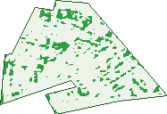
Green: 10 m cells where trees dominate, satellite 2021. Blue: water. The line is the suburb boundary.
| Canopy share, 1 m canopy height map, 2020 | 7.4% |
|---|---|
| Surveyed canopy, Greater Sydney aerial survey, 2019 | 11.9% |
| Land with trees, 10 m satellite map, 2021 | 4.6% |
Demographics
Unemployment 2.8% · Labour-force participation 64.3%
Population by age in Russell Lea
| 0-4 | 235 |
|---|---|
| 5-14 | 679 |
| 15-19 | 270 |
| 20-24 | 235 |
| 25-34 | 514 |
| 35-44 | 635 |
| 45-54 | 816 |
| 55-64 | 614 |
| 65-74 | 458 |
| 75-84 | 272 |
| 85+ | 187 |
Dwelling types in Russell Lea
| House | 1,215 |
|---|---|
| Townhouse | 138 |
| Apartment | 417 |
| Other | 11 |
Households by weekly income in Russell Lea
| <$650 | 224 |
|---|---|
| $650-1,499 | 279 |
| $1,500-2,999 | 410 |
| $3,000+ | 757 |
Top ancestries in Russell Lea
| English | 1,182 |
|---|---|
| Italian | 1,154 |
| Australian | 1,152 |
| Other | 577 |
| Irish | 553 |
| Chinese | 329 |
Housing tenure in Russell Lea
| Owned | 667 |
|---|---|
| Mortgage | 624 |
| Rented | 456 |
| Other | 16 |
Cars per household in Russell Lea
| 0 | 159 |
|---|---|
| 1 | 612 |
| 2 | 688 |
| 3 | 200 |
| 4+ | 110 |
Commute to work in Russell Lea
| Car | 826 |
|---|---|
| Train | 3 |
| Bus | 38 |
| Tram/ferry | 4 |
| Walked | 30 |
| Bicycle | 13 |
| Home | 1,204 |
Top countries of birth in Russell Lea
| Italy | 308 |
|---|---|
| England | 161 |
| China | 90 |
| Greece | 84 |
| New Zealand | 72 |
| Vietnam | 42 |
Languages used at home in Russell Lea
| Italian | 481 |
|---|---|
| Greek | 183 |
| Mandarin | 94 |
| Cantonese | 78 |
| Vietnamese | 54 |
| Spanish | 52 |
Birds & Wildlife Nearby
101,634 bird observations recorded near Russell Lea — most often seen:
- Rainbow Lorikeet (11,942)
- Noisy Miner (9,418)
- Australian White Ibis (6,591)
- Australian Magpie (5,819)
- Silver Gull (5,118)
- Rock Dove (5,026)
- Pied Currawong (4,973)
- Common Myna (4,953)
- Australian Raven (4,431)
- Welcome Swallow (4,004)
- Laughing Kookaburra (3,510)
- Grey Butcherbird (3,238)
- Sulphur-crested Cockatoo (2,852)
Show all 30 birds recorded near Russell Lea
- Australian Brush-turkey (2,483)
- Crested Pigeon (2,465)
- Spotted Turtle-dove (2,093)
- White-faced Heron (1,978)
- Little Corella (1,826)
- Southern Noisy Miner (1,798)
- Masked Lapwing (1,773)
- Eastern Rainbow Lorikeet (1,757)
- Magpie-lark (1,749)
- Superb Fairy-wren (1,611)
- Australasian Figbird (1,596)
- Red Wattlebird (1,580)
- Little Pied Cormorant (1,499)
- Channel-billed Cuckoo (1,474)
- Coastal New South Wales Australian Magpie (1,418)
- Red-whiskered Bulbul (1,340)
- Little Black Cormorant (1,319)
Sightings reported by observers, not a survey, so the counts show what people record rather than what lives here. Source: Atlas of Living Australia.
Nearby Suburbs
The closest suburbs to Russell Lea:
- Wareemba (0.8 km)
- Rodd Point (0.9 km)
- Chiswick (1 km)
- Abbotsford (1.3 km)
- Drummoyne (1.4 km)
- Five Dock (1.5 km)
- Henley (1.8 km)
- Huntleys Point (2.1 km)
Embed this suburb
Add this free Russell Lea stat card to your own site — just copy the code:
Preview:
Cite this page
Quoting these figures? Copy the credit line:
Keep an eye on Russell Lea
One email when this data meaningfully changes — new census figures, prices, rankings. No spam, unsubscribe anytime.
Streets
- Alice Avenue (11)
- Atkins Avenue (22)
- Barnstaple Road (8)
- Bay Road (228)
- Boronia Avenue (12)
- Bouvardia Street (78)
- Brennans Lane (7)
- Brent Street (21)
- Burnell Street (69)
- Byrne Avenue (46)
- Clare Crescent (30)
- Clements Street (77)
- Dalmeny Avenue (24)
- Edenholme Road (101)
- Hampden Road (297)
- Henley Marine Drive (21)
- Janet Street (24)
- Lamrock Avenue (34)
- Lea Avenue (38)
- Lenore Street (54)
- Liege Street (26)
- Lithgow Street (1)
- Lucas Avenue (17)
- Lyons Road (261)
- Margaret Street (22)
- Mcculloch Street (26)
- Mons Street (52)
- Mooculta Street (27)
- Murray Street (14)
- Myalora Street (25)
- North Court Road (22)
- Parkview Road (67)
- Pine Avenue (22)
- Potter Street (39)
- Reims Street (7)
- Robert Avenue (19)
- Rowley Road (45)
- Russell Street (85)
- Seabrook Avenue (26)
- Sibbick Street (61)
- Speed Avenue (20)
- Tait Street (50)
- The Crescent (11)
- The Parade (46)
- Undine Street (48)
- Warwillah Road (14)
- Whittall Street (4)