Drummoyne NSW 2047
8,339 addresses · 74 streets
Reid Electorate › Canada Bay LGA › Drummoyne · 5 km from Sydney
📦 Thinking of moving here? Read the Drummoyne moving guide

Living Here
An affluent harbourside inner-western Sydney suburb on the Parramatta River, Drummoyne mixes period homes with apartments. Households average 2.3 people and the median age is 42. Median household income is high at $2,776 a week, with rent around $600.
Drummoyne is a suburb of New South Wales, home to about 12,011 people, with a median age of 42. The typical household earns around $2,776 a week, with median rent near $600 a week. Most homes are apartments. About 62% of households own their home and 36% rent. Most workers work from home. Common community backgrounds include English, Australian, Irish. On the ABS socio-economic scale it sits in decile 10 of 10 nationally — a relatively advantaged area.
Over time — Census 2001 → 2021
Dashed line: district figures for the Drummoyne - Rodd Point statistical area (SA2), the smallest area the ABS published before 2011. Solid line: Drummoyne itself.
Getting Around & Local Services
4 childcare & kindergartens
2 beauty salons
2 carpenters
Getting around. Train station: Wollstonecraft, 4.1 km north-east · Metro station: Barangaroo, 4.6 km east · Light rail stop: Leichhardt North, 2.6 km south · Bus interchange: Mount St (501), 4.2 km south-east · Ferry wharf: Drummoyne Ferry Wharf, 750 m north-east · Airport: Rose Bay Seaplane Base, 10.3 km east.
Socio-economic Standing
Deciles from 1 (lowest) to 10 (highest), against all Australian suburbs. The overall figure weighs advantage and disadvantage together; economic resources counts income and housing, and education & jobs counts qualifications and occupation. They often differ. Source: ABS SEIFA 2021.
Tree cover
🌳 Tree canopy: 10.5% share of land under canopy · satellite map, 2020
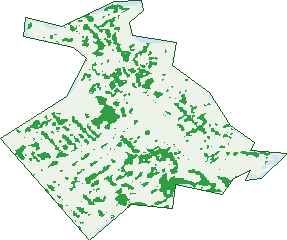
Green: 10 m cells where trees dominate, satellite 2021. Blue: water. The line is the suburb boundary.
| Canopy share, 1 m canopy height map, 2020 | 10.5% |
|---|---|
| Surveyed canopy, Greater Sydney aerial survey, 2019 | 16.7% |
| Land with trees, 10 m satellite map, 2021 | 13.6% |
Demographics
Unemployment 3.1% · Labour-force participation 66%
Population by age in Drummoyne
| 0-4 | 672 |
|---|---|
| 5-14 | 1,206 |
| 15-19 | 525 |
| 20-24 | 556 |
| 25-34 | 1,719 |
| 35-44 | 1,798 |
| 45-54 | 1,699 |
| 55-64 | 1,488 |
| 65-74 | 1,190 |
| 75-84 | 746 |
| 85+ | 406 |
Dwelling types in Drummoyne
| House | 1,496 |
|---|---|
| Townhouse | 533 |
| Apartment | 2,810 |
| Other | 70 |
Households by weekly income in Drummoyne
| <$650 | 481 |
|---|---|
| $650-1,499 | 800 |
| $1,500-2,999 | 1,181 |
| $3,000+ | 2,247 |
Top ancestries in Drummoyne
| English | 3,500 |
|---|---|
| Australian | 2,970 |
| Other | 1,750 |
| Irish | 1,631 |
| Italian | 1,300 |
| Scottish | 1,092 |
Housing tenure in Drummoyne
| Owned | 1,650 |
|---|---|
| Mortgage | 1,398 |
| Rented | 1,762 |
| Other | 72 |
Cars per household in Drummoyne
| 0 | 429 |
|---|---|
| 1 | 2,342 |
| 2 | 1,599 |
| 3 | 353 |
| 4+ | 139 |
Commute to work in Drummoyne
| Car | 1,838 |
|---|---|
| Train | 6 |
| Bus | 163 |
| Tram/ferry | 18 |
| Walked | 130 |
| Bicycle | 45 |
| Home | 3,386 |
Top countries of birth in Drummoyne
| England | 478 |
|---|---|
| Italy | 255 |
| New Zealand | 252 |
| China | 204 |
| Greece | 125 |
| India | 119 |
Languages used at home in Drummoyne
| Italian | 383 |
|---|---|
| Greek | 360 |
| Mandarin | 215 |
| Cantonese | 179 |
| Arabic | 165 |
| Spanish | 141 |
Birds & Wildlife Nearby
106,129 bird observations recorded near Drummoyne — most often seen:
- Rainbow Lorikeet (12,912)
- Noisy Miner (10,168)
- Australian Magpie (6,700)
- Australian White Ibis (5,957)
- Silver Gull (5,510)
- Pied Currawong (5,322)
- Rock Dove (4,660)
- Welcome Swallow (4,286)
- Laughing Kookaburra (4,255)
- Australian Raven (4,062)
- Common Myna (4,039)
- Australian Brush-turkey (3,894)
- Grey Butcherbird (3,384)
Show all 30 birds recorded near Drummoyne
- Sulphur-crested Cockatoo (3,107)
- Crested Pigeon (2,219)
- White-faced Heron (2,164)
- Southern Noisy Miner (2,068)
- Masked Lapwing (1,992)
- Eastern Rainbow Lorikeet (1,866)
- Superb Fairy-wren (1,747)
- White-browed Scrubwren (1,712)
- Little Pied Cormorant (1,688)
- Channel-billed Cuckoo (1,650)
- Little Black Cormorant (1,645)
- Spotted Turtle-dove (1,599)
- Magpie-lark (1,579)
- Tawny Frogmouth (1,540)
- Little Corella (1,507)
- Red Wattlebird (1,470)
- Australian King-parrot (1,427)
Sightings reported by observers, not a survey, so the counts show what people record rather than what lives here. Source: Atlas of Living Australia.
Nearby Suburbs
The closest suburbs to Drummoyne:
- Russell Lea (1.4 km)
- Chiswick (1.5 km)
- Huntleys Point (1.5 km)
- Rodd Point (1.9 km)
- Rozelle (2 km)
- Henley (2 km)
- Wareemba (2.1 km)
- Abbotsford (2.2 km)
Embed this suburb
Add this free Drummoyne stat card to your own site — just copy the code:
Preview:
Cite this page
Quoting these figures? Copy the credit line:
Keep an eye on Drummoyne
One email when this data meaningfully changes — new census figures, prices, rankings. No spam, unsubscribe anytime.
Streets
- Albert Street (6)
- Alexandra Street (232)
- Arcadia Avenue (5)
- Barney Street (16)
- Bayswater Street (111)
- Bowman Street (101)
- Bradley Street (9)
- Bray Street (3)
- Broughton Street (28)
- Budd Street (13)
- Burnell Street (23)
- Byrne Avenue (24)
- Cambridge Road (26)
- Cary Street (359)
- Church Street (88)
- Clements Street (19)
- College Street (216)
- Collingwood Street (242)
- Cometrowe Street (33)
- Day Street (103)
- Dempsey Place (2)
- Dening Street (94)
- Drummoyne Avenue (220)
- Duncan Street (6)
- Edwin Street (36)
- Formosa Street (247)
- Gears Avenue (38)
- Gipps Street (186)
- Henley Marine Drive (33)
- Henley Street (33)
- Henricks Avenue (5)
- Hinkler Court (5)
- Hythe Street (2)
- Janet Street (48)
- Lower St Georges Crescent (110)
- Lyons Road (529)
- Market Street (40)
- Marlborough Street (241)
- Mary Street (22)
- Millar Street (61)
- Moore Street (117)
- Napier Street (55)
- Park Avenue (56)
- Plunkett Street (51)
- Polding Street (63)
- Queen Victoria Street (16)
- Raglan Street (13)
- Rawson Avenue (8)
- Ray Street (8)
- Raymond Avenue (3)
- Renwick Street (114)
- Richards Avenue (18)
- Riverside Mews (18)
- Roseby Street (342)
- Seymour Street (15)
- Sisters Crescent (6)
- South Street (33)
- St Georges Crescent (763)
- Stuart Crescent (47)
- Tavistock Street (49)
- The Esplanade (50)
- The Parade (47)
- Therry Lane (1)
- Therry Street (81)
- Thompson Street (186)
- Thornley Street (40)
- Tranmere Street (322)
- Ullathorne Street (15)
- Victoria Place (466)
- Victoria Road (616)
- Westbourne Street (71)
- Wolseley Street (493)
- Wrights Point (7)
- Wrights Road (534)