Macquarie Fields NSW 2564
6,122 addresses · 192 streets
Werriwa Electorate › Campbelltown LGA › Macquarie Fields · 32 km from Sydney
📦 Thinking of moving here? Read the Macquarie Fields moving guide

Living Here
Macquarie Fields is a suburb of New South Wales, home to about 14,023 people, with a median age of 36. The typical household earns around $1,374 a week, with median rent near $340 a week. Most homes are houses. About 55% of households own their home and 44% rent. Most workers drive to work. Common community backgrounds include Australian, English, Ancestry NS. On the ABS socio-economic scale it sits in decile 1 of 10 nationally — a more disadvantaged area.
Over time — Census 2001 → 2021
Dashed line: district figures for the Macquarie Fields - Glenfield statistical area (SA2), the smallest area the ABS published before 2011. Solid line: Macquarie Fields itself.
Getting Around & Local Services
5 supermarkets
1 beach
4 gyms & sports centres
1 bakery
1 electrician
3 places to stay
Getting around. Train station: Macquarie Fields, 1.4 km north-west · Airport: Bankstown Airport, 12 km north-east.
Socio-economic Standing
Deciles from 1 (lowest) to 10 (highest), against all Australian suburbs. The overall figure weighs advantage and disadvantage together; economic resources counts income and housing, and education & jobs counts qualifications and occupation. They often differ. Source: ABS SEIFA 2021.
Tree cover
🌳 Tree canopy: 23.2% share of land under canopy · satellite map, 2020
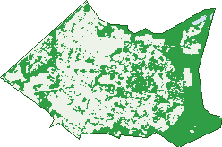
Green: 10 m cells where trees dominate, satellite 2021. Blue: water. The line is the suburb boundary.
| Canopy share, 1 m canopy height map, 2020 | 23.2% |
|---|---|
| Surveyed canopy, Greater Sydney aerial survey, 2019 | 20.3% |
| Land with trees, 10 m satellite map, 2021 | 46.3% |
Demographics
Unemployment 9.1% · Labour-force participation 49.5%
Population by age in Macquarie Fields
| 0-4 | 999 |
|---|---|
| 5-14 | 2,210 |
| 15-19 | 978 |
| 20-24 | 834 |
| 25-34 | 1,795 |
| 35-44 | 2,069 |
| 45-54 | 1,706 |
| 55-64 | 1,556 |
| 65-74 | 1,162 |
| 75-84 | 595 |
| 85+ | 125 |
Dwelling types in Macquarie Fields
| House | 3,201 |
|---|---|
| Townhouse | 1,300 |
| Apartment | 57 |
| Other | 0 |
Households by weekly income in Macquarie Fields
| <$650 | 901 |
|---|---|
| $650-1,499 | 1,426 |
| $1,500-2,999 | 1,421 |
| $3,000+ | 502 |
Top ancestries in Macquarie Fields
| Other | 4,486 |
|---|---|
| Australian | 2,949 |
| English | 2,576 |
| Ancestry NS | 1,212 |
| Indian | 1,119 |
| Aboriginal | 620 |
Housing tenure in Macquarie Fields
| Owned | 956 |
|---|---|
| Mortgage | 1,526 |
| Rented | 1,958 |
| Other | 44 |
Cars per household in Macquarie Fields
| 0 | 526 |
|---|---|
| 1 | 1,957 |
| 2 | 1,434 |
| 3 | 388 |
| 4+ | 163 |
Commute to work in Macquarie Fields
| Car | 2,329 |
|---|---|
| Train | 291 |
| Bus | 41 |
| Tram/ferry | 0 |
| Walked | 47 |
| Bicycle | 3 |
| Home | 1,083 |
Top countries of birth in Macquarie Fields
| Bangladesh | 981 |
|---|---|
| India | 740 |
| New Zealand | 370 |
| Philippines | 367 |
| Fiji | 351 |
| Nepal | 331 |
Languages used at home in Macquarie Fields
| Bengali | 1,307 |
|---|---|
| Arabic | 562 |
| Nepali | 381 |
| Samoan | 372 |
| Hindi | 365 |
| Vietnamese | 238 |
Birds & Wildlife Nearby
23,628 bird observations recorded near Macquarie Fields — most often seen:
- Rainbow Lorikeet (2,000)
- Sulphur-crested Cockatoo (1,682)
- Noisy Miner (1,665)
- Australian Magpie (1,373)
- Australian Raven (1,369)
- Common Myna (1,242)
- Grey Butcherbird (1,007)
- Superb Fairy-wren (910)
- Magpie-lark (857)
- Yellow-faced Honeyeater (804)
- Eastern Rosella (715)
- Australian King-parrot (670)
- Noisy Friarbird (635)
Show all 30 birds recorded near Macquarie Fields
- Crested Pigeon (623)
- Pied Currawong (602)
- Laughing Kookaburra (582)
- Galah (579)
- Black-faced Cuckoo-shrike (545)
- Grey Fantail (543)
- Bell Miner (539)
- Willie Wagtail (521)
- Spotted Pardalote (517)
- Australian White Ibis (508)
- Common Starling (490)
- Little Wattlebird (467)
- Rock Dove (454)
- Welcome Swallow (447)
- Eastern Yellow Robin (442)
- Coastal Spotted Pardalote (429)
- Spotted Turtle-dove (411)
Sightings reported by observers, not a survey, so the counts show what people record rather than what lives here. Source: Atlas of Living Australia.
Nearby Suburbs
The closest suburbs to Macquarie Fields:
- Macquarie Links (2.1 km)
- Long Point (2.3 km)
- Glenfield (2.3 km)
- Ingleburn (2.5 km)
- Bardia (3.2 km)
- Edmondson Park (4.6 km)
- Casula (4.6 km)
- Minto Heights (5.2 km)
Embed this suburb
Add this free Macquarie Fields stat card to your own site — just copy the code:
Preview:
Cite this page
Quoting these figures? Copy the credit line:
Keep an eye on Macquarie Fields
One email when this data meaningfully changes — new census figures, prices, rankings. No spam, unsubscribe anytime.
Streets
- Adam Place (22)
- Adrian Street (91)
- Agathis Road (7)
- Alexander Crescent (66)
- Alice Street (51)
- Alpine Place (17)
- Amaranthus Place (40)
- Ambrosia Street (22)
- Anne Way (8)
- Apple Place (8)
- Argyle Place (17)
- Arum Place (5)
- Astelia Street (32)
- Atchison Road (141)
- Azalea Place (64)
- Bangalay Place (25)
- Bangalay Road (26)
- Beech Place (9)
- Begonia Place (9)
- Belah Place (12)
- Bensley Road (139)
- Berrigan Crescent (48)
- Bingara Road (50)
- Birch Place (12)
- Blackwood Crescent (47)
- Boree Place (15)
- Box Place (13)
- Bramble Place (11)
- Bromus Place (11)
- Brooks Street (151)
- Bunbury Road (55)
- Bundy Close (17)
- Bunya Place (8)
- Burns Avenue (14)
- Buttercup Street (30)
- Cadogan Road (23)
- Cassia Place (12)
- Casuarina Place (15)
- Catkin Way (9)
- Cedric Street (18)
- Celtis Place (12)
- Cestrum Avenue (12)
- Cherry Place (8)
- Church Street (3)
- Clarence Street (55)
- Clematis Place (11)
- Clover Place (14)
- Cooba Place (14)
- Coolabah Place (16)
- Coronata Way (23)
- Correa Place (13)
- Cosmos Place (6)
- Costata Place (31)
- Cottonwood Crescent (36)
- Cotula Place (11)
- Cranberry Street (41)
- Cress Place (10)
- Crinum Place (7)
- Croton Place (9)
- Curran Avenue (9)
- Cyclamen Place (36)
- Cyprus Street (22)
- Daisy Place (4)
- Daphne Place (7)
- Ebony Place (10)
- Edgar Street (87)
- Edith Avenue (5)
- Edward Street (34)
- Elder Place (17)
- Emex Place (19)
- Eucalyptus Drive (160)
- Eurabbie Place (10)
- Evelyn Street (157)
- Ficus Place (10)
- Fields Road (111)
- Fifth Avenue (23)
- First Avenue (74)
- Flame Crescent (15)
- Flax Place (11)
- Fourth Avenue (64)
- Fraser Street (47)
- Fruticosa Way (22)
- Fuchsia Crescent (104)
- Gardenia Place (18)
- Gentian Avenue (34)
- Geranium Avenue (39)
- Geum Place (11)
- Gimlet Place (12)
- Gloucester Street (32)
- Gossamer Place (13)
- Grevillea Crescent (44)
- Groundsel Avenue (36)
- Gumnut Place (7)
- Hakea Place (17)
- Harold Street (101)
- Harvey Street (35)
- Hawthorne Place (24)
- Helicia Road (93)
- Hibiscus Crescent (44)
- Hickory Place (17)
- Hillana Way (5)
- Hovea Place (11)
- Hyacinth Avenue (55)
- Hydrangea Place (46)
- Ironbark Crescent (27)
- Jillian Place (8)
- Johns Avenue (14)
- Juniper Way (11)
- Kenneth Street (10)
- Knotwood Avenue (27)
- Kurrajong Road (1)
- Lantana Street (86)
- Laurel Place (17)
- Leopardwood Place (7)
- Lilly Pilly Way (2)
- Lindley Avenue (10)
- Linum Street (17)
- Lobelia Street (12)
- Lotus Place (8)
- Macquarie Road (24)
- Maculata Crescent (7)
- Magnolia Place (7)
- Mahogany Place (22)
- Mallee Place (10)
- Maple Place (12)
- Marlock Place (20)
- Mary Street (71)
- Maxwell Street (15)
- Melaleuca Drive (12)
- Melia Place (14)
- Melliodora Way (10)
- Mentha Place (29)
- Merritt Place (8)
- Mimulus Place (11)
- Mistletoe Avenue (32)
- Montana Way (14)
- Moonah Place (13)
- Mountain Ash Road (11)
- Mulga Place (9)
- Myee Road (131)
- Nicholii Place (6)
- Nigel Place (19)
- Noeline Avenue (9)
- Oakley Road (11)
- Olea Place (6)
- Olive Place (8)
- Orchid Place (32)
- Paper Bark Place (12)
- Parkland Avenue (65)
- Parliament Road (233)
- Pelargonium Crescent (28)
- Peppermint Road (20)
- Petunia Place (24)
- Plume Close (8)
- Poppy Place (8)
- Pritchard Road (42)
- Punicea Way (10)
- Railway Parade (63)
- Redwood Place (10)
- Risdoni Way (22)
- Rosemary Place (10)
- Rosewood Drive (36)
- Rubida Way (17)
- Saligna Way (37)
- Sapium Way (35)
- Sarissa Way (10)
- Saywell Road (333)
- Scribbly Place (15)
- Second Avenue (59)
- Sixth Avenue (6)
- Snow Gum Street (20)
- Starleaf Way (8)
- Striata Way (5)
- Tea Tree Crescent (39)
- Telopea Place (31)
- Third Avenue (153)
- Trinervis Way (10)
- Vanessa Place (9)
- Victoria Road (137)
- Waratah Crescent (99)
- Wattle Avenue (74)
- Westringia Place (23)
- Wild Orange Place (11)
- Wilfred Street (17)
- Wilfrid Street (18)
- Wilga Place (10)
- Wills Road (12)
- Windsor Street (12)
- Wollemi Close (13)
- Woollybutt Place (12)
- Yarran Place (8)
- Yate Place (14)