Glenfield NSW 2167
4,166 addresses · 139 streets
Werriwa Electorate › Campbelltown LGA › Glenfield · 31 km from Sydney
📦 Thinking of moving here? Read the Glenfield moving guide

Living Here
Glenfield is a suburb of New South Wales, home to about 10,536 people, with a median age of 36. The typical household earns around $2,070 a week, with median rent near $420 a week. Most homes are houses. About 64% of households own their home and 34% rent. Most workers drive to work. Common community backgrounds include Australian, English, Indian. On the ABS socio-economic scale it sits in decile 7 of 10 nationally — a mid-range area.
Over time — Census 2001 → 2021
Dashed line: district figures for the Macquarie Fields - Glenfield statistical area (SA2), the smallest area the ABS published before 2011. Solid line: Glenfield itself.
Getting Around & Local Services
6 supermarkets
1 beach
2 pharmacies
1 dentist
1 optometrist
4 childcare & kindergartens
5 gyms & sports centres
2 bakeries
1 butcher
1 hairdresser
1 beauty salon
1 electrician
Getting around. Train station: Glenfield, 300 m west · Airport: Bankstown Airport, 10.4 km north-east.
Socio-economic Standing
Deciles from 1 (lowest) to 10 (highest), against all Australian suburbs. The overall figure weighs advantage and disadvantage together; economic resources counts income and housing, and education & jobs counts qualifications and occupation. They often differ. Source: ABS SEIFA 2021.
Tree cover
🌳 Tree canopy: 13% share of land under canopy · satellite map, 2020
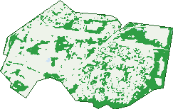
Green: 10 m cells where trees dominate, satellite 2021. Blue: water. The line is the suburb boundary.
| Canopy share, 1 m canopy height map, 2020 | 13.0% |
|---|---|
| Surveyed canopy, Greater Sydney aerial survey, 2019 | 12.1% |
| Land with trees, 10 m satellite map, 2021 | 27.9% |
Demographics
Unemployment 5.8% · Labour-force participation 59.3%
Population by age in Glenfield
| 0-4 | 799 |
|---|---|
| 5-14 | 1,405 |
| 15-19 | 582 |
| 20-24 | 631 |
| 25-34 | 1,537 |
| 35-44 | 1,759 |
| 45-54 | 1,270 |
| 55-64 | 1,069 |
| 65-74 | 727 |
| 75-84 | 430 |
| 85+ | 327 |
Dwelling types in Glenfield
| House | 2,233 |
|---|---|
| Townhouse | 907 |
| Apartment | 75 |
| Other | 7 |
Households by weekly income in Glenfield
| <$650 | 359 |
|---|---|
| $650-1,499 | 697 |
| $1,500-2,999 | 1,162 |
| $3,000+ | 817 |
Top ancestries in Glenfield
| Other | 3,524 |
|---|---|
| Australian | 1,504 |
| English | 1,432 |
| Indian | 1,408 |
| Ancestry NS | 864 |
| Chinese | 811 |
Housing tenure in Glenfield
| Owned | 715 |
|---|---|
| Mortgage | 1,336 |
| Rented | 1,093 |
| Other | 37 |
Cars per household in Glenfield
| 0 | 232 |
|---|---|
| 1 | 1,247 |
| 2 | 1,222 |
| 3 | 350 |
| 4+ | 138 |
Commute to work in Glenfield
| Car | 1,863 |
|---|---|
| Train | 306 |
| Bus | 23 |
| Tram/ferry | 0 |
| Walked | 40 |
| Bicycle | 8 |
| Home | 1,518 |
Top countries of birth in Glenfield
| India | 980 |
|---|---|
| Nepal | 495 |
| Bangladesh | 462 |
| Philippines | 376 |
| China | 329 |
| New Zealand | 242 |
Languages used at home in Glenfield
| Bengali | 626 |
|---|---|
| Nepali | 610 |
| Arabic | 395 |
| Hindi | 379 |
| Mandarin | 344 |
| Malayalam | 273 |
Birds & Wildlife Nearby
21,436 bird observations recorded near Glenfield — most often seen:
- Rainbow Lorikeet (2,149)
- Noisy Miner (1,630)
- Sulphur-crested Cockatoo (1,505)
- Australian Magpie (1,441)
- Common Myna (1,152)
- Australian Raven (1,125)
- Grey Butcherbird (812)
- Magpie-lark (680)
- Yellow-faced Honeyeater (678)
- Superb Fairy-wren (672)
- Eastern Rosella (641)
- Crested Pigeon (609)
- Galah (602)
Show all 30 birds recorded near Glenfield
- Australian King-parrot (557)
- Pied Currawong (543)
- Noisy Friarbird (540)
- Rock Dove (532)
- Laughing Kookaburra (509)
- Grey Fantail (481)
- Australian White Ibis (469)
- Bell Miner (457)
- Australian Wood Duck (446)
- Black-faced Cuckoo-shrike (439)
- Spotted Turtle-dove (412)
- Coastal Spotted Pardalote (402)
- Spotted Pardalote (401)
- Eastern Rainbow Lorikeet (398)
- Red-whiskered Bulbul (394)
- Common Starling (383)
- Eastern Whipbird (377)
Sightings reported by observers, not a survey, so the counts show what people record rather than what lives here. Source: Atlas of Living Australia.
Nearby Suburbs
The closest suburbs to Glenfield:
- Macquarie Fields (2.3 km)
- Casula (2.3 km)
- Macquarie Links (2.4 km)
- Bardia (3.2 km)
- Edmondson Park (3.7 km)
- Prestons (3.8 km)
- Lurnea (4 km)
- Ingleburn (4.4 km)
Embed this suburb
Add this free Glenfield stat card to your own site — just copy the code:
Preview:
Cite this page
Quoting these figures? Copy the credit line:
Keep an eye on Glenfield
One email when this data meaningfully changes — new census figures, prices, rankings. No spam, unsubscribe anytime.
Streets
- Active Close (2)
- Adamson Street (13)
- Albermarle Road (12)
- Albion Crescent (6)
- Almorah Street (10)
- Aroa Place (10)
- Aseki Avenue (16)
- Atlantic Boulevard (126)
- Atlas Way (3)
- Baldwin Avenue (20)
- Balimo Place (25)
- Banz Place (4)
- Barwell Street (9)
- Batavia Avenue (4)
- Bellona Terrace (17)
- Bellona Walk (10)
- Belmont Road (212)
- Bensbach Road (43)
- Blenheim Place (12)
- Boddingtons Road (25)
- Bosavi Street (6)
- Bougainville Road (39)
- Brampton Avenue (6)
- Britannia Drive (24)
- Brothers Lane (20)
- Broxbornebury Street (8)
- Buin Place (9)
- Buka Place (5)
- Bulolo Place (10)
- Buna Place (8)
- Calvados Street (25)
- Cambridge Avenue (1)
- Campbelltown Road (9)
- Canterbury Road (88)
- Champion Street (15)
- Chelsea Place (7)
- Chesham Parade (52)
- Daru Place (11)
- Dobu Place (29)
- Eleanor Drive (51)
- English Street (32)
- Epo Place (5)
- Eva Place (4)
- Fawcett Street (217)
- Fergusson Street (39)
- Florentia Street (10)
- Foreman Street (79)
- Fortune Street (24)
- Fyfe Place (6)
- Gazelle Street (47)
- Glatton Road (18)
- Glenfield Road (78)
- Globe Street (5)
- Glory Road (30)
- Gona Place (9)
- Goodenough Street (39)
- Goroka Street (13)
- Grahame Avenue (12)
- Grenada Road (42)
- Guardian Crescent (14)
- Hadlow Avenue (50)
- Hagen Place (5)
- Harrow Road (386)
- Hebe Terrace (26)
- Hillsborough Crescent (23)
- Hindostan Road (21)
- Hosking Crescent (98)
- Huon Place (5)
- Hurlstone Avenue (39)
- Isabella Crescent (49)
- Jacquinot Place (100)
- Janus Street (12)
- Karius Street (7)
- Kennett Place (7)
- Kerema Place (20)
- Kikori Place (49)
- Kiriwina Place (10)
- Kitava Place (15)
- Kokoda Place (16)
- Kubor Street (6)
- Lae Place (9)
- Lalor Street (12)
- Loftus Street (1)
- Madang Place (12)
- Magee Lane (6)
- Manam Place (17)
- Manus Place (9)
- Mariner Street (20)
- Mary Ann Drive (155)
- Matilda Lane (19)
- Matilda Walk (4)
- Mekeo Place (7)
- Mellish Parade (46)
- Mendi Place (15)
- Mermaid Crescent (25)
- Midas Way (2)
- Minj Place (3)
- Minstrel Street (12)
- Misima Place (16)
- Monckton Place (24)
- Moresby Avenue (6)
- Morley Place (6)
- Motu Place (5)
- Neva Street (15)
- Newtown Road (25)
- Northampton Drive (113)
- Numa Way (2)
- O'malley Place (17)
- Old Glenfield Road (7)
- Oro Place (9)
- Owen Stanley Road (47)
- Perseus Lane (4)
- Popondetta Place (34)
- Railway Parade (115)
- Regalia Crescent (17)
- Rentoul Street (11)
- Rigo Place (6)
- Rolla Road (21)
- Roslin Castle Court (6)
- Rossell Place (8)
- Salamaua Place (23)
- Salisbury Avenue (30)
- Sovereign Circuit (94)
- Stirling Place (14)
- Sulu Way (33)
- Tagula Place (15)
- Tari Way (22)
- Tellicherry Road (15)
- Three Bees Drive (19)
- Tottenham Place (15)
- Trafalgar Street (105)
- Trobriand Crescent (98)
- Tudor Place (5)
- Tyne Walk (15)
- Waterloo Place (11)
- Wau Place (11)
- Wentworth Avenue (26)
- Woodlark Place (53)
- Yule Place (5)