Greystanes NSW 2145
9,172 addresses · 221 streets
McMahon Electorate › Cumberland LGA › Greystanes · 25 km from Sydney
📦 Thinking of moving here? Read the Greystanes moving guide

Living Here
An established family suburb in Sydney's west near Parramatta, Greystanes is built around detached homes. Households average 3.0 people and the median age is 39. Median household income is $1,930 a week, with rent around $480.
Greystanes is a suburb of New South Wales, home to about 23,511 people, with a median age of 39. The typical household earns around $1,930 a week, with median rent near $480 a week. Most homes are houses. About 78% of households own their home and 21% rent. Most workers drive to work. Common community backgrounds include Australian, English, Lebanese. On the ABS socio-economic scale it sits in decile 7 of 10 nationally — a mid-range area.
Over time — Census 2001 → 2021
Dashed line: district figures for the Greystanes - Pemulwuy statistical area (SA2), the smallest area the ABS published before 2011. Solid line: Greystanes itself.
Getting Around & Local Services
4 pharmacies
1 medical clinic
2 physiotherapists
13 libraries
- Greystanes Library
- Wentworthville Library
- Smithfield Library
- Merrylands Central Library
- Constitution Hill Branch Library
- Guildford Library
- Federal Court of Australia Library & Information Services, Parramatta
- Parramatta Library
- Western Sydney University Parramatta City Campus Library
- Fairfield Library and Cafe
4 hairdressers
2 beauty salons
2 electricians
Getting around. Train station: Pendle Hill, 2.7 km north · Light rail stop: Westmead, 4.2 km north-east · Bus interchange: Parramatta EA, 7.4 km east · Ferry wharf: Parramatta Ferry Wharf, 6 km east · Airport: Bankstown Airport, 12.1 km south.
Socio-economic Standing
Deciles from 1 (lowest) to 10 (highest), against all Australian suburbs. The overall figure weighs advantage and disadvantage together; economic resources counts income and housing, and education & jobs counts qualifications and occupation. They often differ. Source: ABS SEIFA 2021.
Tree cover
🌳 Tree canopy: 8.9% share of land under canopy · satellite map, 2020
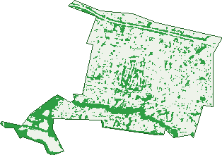
Green: 10 m cells where trees dominate, satellite 2021. Blue: water. The line is the suburb boundary.
| Canopy share, 1 m canopy height map, 2020 | 8.9% |
|---|---|
| Surveyed canopy, Greater Sydney aerial survey, 2019 | 9.9% |
| Land with trees, 10 m satellite map, 2021 | 22.7% |
Demographics
Unemployment 4.5% · Labour-force participation 52.8%
Population by age in Greystanes
| 0-4 | 1,508 |
|---|---|
| 5-14 | 3,433 |
| 15-19 | 1,462 |
| 20-24 | 1,322 |
| 25-34 | 2,584 |
| 35-44 | 3,295 |
| 45-54 | 3,014 |
| 55-64 | 2,466 |
| 65-74 | 2,430 |
| 75-84 | 1,579 |
| 85+ | 430 |
Dwelling types in Greystanes
| House | 6,345 |
|---|---|
| Townhouse | 1,001 |
| Apartment | 101 |
| Other | 0 |
Households by weekly income in Greystanes
| <$650 | 1,003 |
|---|---|
| $650-1,499 | 1,871 |
| $1,500-2,999 | 2,159 |
| $3,000+ | 1,969 |
Top ancestries in Greystanes
| Other | 5,133 |
|---|---|
| Australian | 4,941 |
| English | 3,867 |
| Lebanese | 3,652 |
| Maltese | 1,459 |
| Italian | 1,431 |
Housing tenure in Greystanes
| Owned | 2,989 |
|---|---|
| Mortgage | 2,744 |
| Rented | 1,517 |
| Other | 85 |
Cars per household in Greystanes
| 0 | 324 |
|---|---|
| 1 | 2,310 |
| 2 | 2,994 |
| 3 | 1,091 |
| 4+ | 644 |
Commute to work in Greystanes
| Car | 4,033 |
|---|---|
| Train | 67 |
| Bus | 40 |
| Tram/ferry | 3 |
| Walked | 64 |
| Bicycle | 14 |
| Home | 3,172 |
Top countries of birth in Greystanes
| Lebanon | 1,056 |
|---|---|
| India | 688 |
| Malta | 590 |
| China | 352 |
| Philippines | 317 |
| New Zealand | 303 |
Languages used at home in Greystanes
| Arabic | 3,064 |
|---|---|
| Greek | 490 |
| Turkish | 398 |
| Croatian | 370 |
| Italian | 359 |
| Cantonese | 340 |
Birds & Wildlife Nearby
23,667 bird observations recorded near Greystanes — most often seen:
- Rainbow Lorikeet (2,371)
- Australian White Ibis (1,837)
- Australian Magpie (1,603)
- Noisy Miner (1,533)
- Common Myna (1,351)
- Rock Dove (1,066)
- Australian Raven (958)
- Australian Wood Duck (845)
- Sulphur-crested Cockatoo (819)
- Pacific Black Duck (783)
- Magpie-lark (681)
- Dusky Moorhen (677)
- Crested Pigeon (674)
Show all 30 birds recorded near Greystanes
- Galah (626)
- Welcome Swallow (595)
- Pied Currawong (576)
- Southern Noisy Miner (552)
- Red-whiskered Bulbul (538)
- Masked Lapwing (508)
- Common Starling (505)
- Spotted Turtle-dove (502)
- Coastal New South Wales Australian Magpie (487)
- Eastern Rainbow Lorikeet (478)
- Eastern Australian Raven (470)
- Eastern Asian Spotted Dove (461)
- Willie Wagtail (452)
- Birds (449)
- Eurasian Coot (435)
- Superb Fairy-wren (426)
- White-faced Heron (409)
Sightings reported by observers, not a survey, so the counts show what people record rather than what lives here. Source: Atlas of Living Australia.
Nearby Suburbs
The closest suburbs to Greystanes:
- Pemulwuy (1.7 km)
- South Wentworthville (2.1 km)
- Woodpark (2.3 km)
- Pendle Hill (2.3 km)
- Merrylands West (2.6 km)
- Wentworthville (2.8 km)
- Girraween (2.8 km)
- Smithfield (3.3 km)
Embed this suburb
Add this free Greystanes stat card to your own site — just copy the code:
Preview:
Cite this page
Quoting these figures? Copy the credit line:
Keep an eye on Greystanes
One email when this data meaningfully changes — new census figures, prices, rankings. No spam, unsubscribe anytime.
Streets
- Acacia Place (14)
- Adler Parade (167)
- Adrian Place (17)
- Alpha Road (71)
- Ash Street (7)
- Aster Street (21)
- Azalea Street (57)
- Baden Street (45)
- Ballina Street (34)
- Bambil Street (25)
- Banksia Place (8)
- Barwon Street (13)
- Bathurst Street (63)
- Bayfield Road (24)
- Beechwood Avenue (92)
- Benaud Street (45)
- Benjamin Street (1)
- Beresford Road (140)
- Berith Road (58)
- Bernie Street (20)
- Betts Road (26)
- Bilpin Street (18)
- Birriwa Street (56)
- Blackbutt Crescent (39)
- Bogan Street (24)
- Bokhara Crescent (7)
- Bolaro Avenue (72)
- Bowral Street (45)
- Bradman Street (106)
- Braeside Road (150)
- Brampton Place (8)
- Brighton Street (42)
- Bromwich Street (3)
- Burra Place (18)
- Camellia Street (49)
- Canal Road (121)
- Carnation Street (37)
- Carolyn Street (28)
- Carter Street (6)
- Casino Road (71)
- Cedar Street (9)
- Cedarwood Close (4)
- Cobar Street (1)
- Colo Place (8)
- Conifer Court (18)
- Cooma Road (63)
- Cotter Place (6)
- Cowra Street (15)
- Crosby Street (70)
- Crystal Street (35)
- Cudgee Place (4)
- Cumberland Road (242)
- Curra Place (8)
- Cyril Street (16)
- Daffodil Street (16)
- Dahlia Street (86)
- Daisy Street (60)
- Damien Avenue (115)
- Daniel Street (24)
- Darling Street (207)
- Darmenia Avenue (23)
- Dawn Street (162)
- Dean Street (2)
- Deborah Street (7)
- Dennis Street (59)
- Doris Street (6)
- Dwight Street (13)
- Eldridge Road (62)
- Elm Street (7)
- Elvina Street (12)
- Enid Street (10)
- Esther Street (7)
- Ettalong Road (147)
- Eva Street (5)
- Finch Place (8)
- Forest Gum Place (32)
- Gardenia Parade (202)
- Gerald Street (89)
- Gipps Road (108)
- Gozo Road (81)
- Grafton Street (67)
- Graham Street (46)
- Great Western Highway (176)
- Gregory Street (95)
- Grevillea Crescent (92)
- Greystanes Road (200)
- Grimmet Street (1)
- Gum Street (9)
- Gwydir Street (59)
- Hackney Street (59)
- Hanbury Street (106)
- Hastings Crescent (14)
- Haywood Place (14)
- Hector Street (6)
- Hedley Street (7)
- Hewitt Avenue (20)
- Hibiscus Street (81)
- Hickory Street (2)
- Hillary Street (28)
- Hilton Street (24)
- Hoad Place (10)
- Hopman Street (71)
- Howard Street (20)
- Hugh Place (6)
- Hyacinth Street (24)
- Hyland Road (15)
- Ian Street (51)
- Ivan Street (41)
- Jan Place (3)
- Jasmine Place (11)
- Jason Street (3)
- Jasper Street (29)
- Jeffrey Avenue (36)
- Jersey Road (95)
- Joan Place (4)
- Jonathan Street (32)
- Kalang Road (14)
- Karuah Street (3)
- Kiah Place (6)
- Kiama Street (69)
- Kippax Street (35)
- Kookaburra Street (41)
- Kootingal Street (107)
- Kurrajong Road (39)
- Lance Crescent (98)
- Lark Place (7)
- Laurence Street (3)
- Laver Place (11)
- Leo Crescent (6)
- Leonard Avenue (19)
- Lester Road (27)
- Levick Road (6)
- Lloyd Street (15)
- Lucinda Road (7)
- Lupin Place (6)
- Macleay Street (42)
- Macquarie Road (144)
- Magnolia Street (34)
- Maple Street (82)
- Mavis Street (8)
- Maxine Road (12)
- Mccabe Street (22)
- Merrylands Road (341)
- Millicent Street (53)
- Milton Place (3)
- Montague Street (79)
- Moruya Crescent (9)
- Mountford Avenue (14)
- Munro Street (76)
- Namoi Street (4)
- Nemesia Street (21)
- Nowra Street (4)
- Nymboida Street (48)
- Oak Street (14)
- Old Prospect Road (296)
- Oldfield Street (72)
- Oleander Street (26)
- Olga Street (6)
- Opal Place (5)
- Orange Street (106)
- Pacific Street (2)
- Pan Crescent (5)
- Pandora Crescent (6)
- Paroo Street (8)
- Patrick Street (4)
- Percival Road (9)
- Percy Street (31)
- Poinciana Parade (24)
- Poppy Place (11)
- Quist Place (6)
- Rachel Street (9)
- Rein Road (19)
- Ringrose Avenue (156)
- Roberta Street (152)
- Roland Street (41)
- Rosalind Street (23)
- Rosewall Street (23)
- Rosewood Drive (35)
- Rowe Place (9)
- Rowena Street (21)
- Royal Place (23)
- Royce Street (65)
- Runyon Avenue (118)
- Sapphire Street (90)
- Sedgman Street (52)
- Simpson Street (7)
- Spotted Gum Place (29)
- Sylvia Place (8)
- Tamarix Street (8)
- Tania Street (6)
- Taree Crescent (6)
- Taylor Street (29)
- Terry Street (11)
- Thelma Street (6)
- Theresa Avenue (2)
- Thora Street (8)
- Tulip Street (56)
- Vernon Street (49)
- Veronica Place (7)
- Victor Street (41)
- Viola Place (17)
- Violet Place (13)
- Virgil Street (18)
- Wallaba Place (9)
- Walnut Street (6)
- Walter Place (8)
- Warner Place (6)
- Warrah Place (11)
- Warrego Place (7)
- Warrina Place (7)
- Wattle Street (20)
- Wayne Crescent (15)
- Wesley Place (20)
- Whalans Road (164)
- White Gum Place (83)
- Willow Street (24)
- Wren Place (3)
- Wyatt Place (8)
- Wyee Place (7)
- Yanda Place (4)
- Yvonne Street (13)