Girraween NSW 2145
3,204 addresses · 34 streets
Greenway Electorate › Cumberland LGA › Girraween · 25 km from Sydney
📦 Thinking of moving here? Read the Girraween moving guide

Living Here
Girraween is a suburb of New South Wales, home to about 6,256 people, with a median age of 36. The typical household earns around $2,378 a week, with median rent near $460 a week. Most homes are townhouses. About 66% of households own their home and 34% rent. Most workers work from home. Common community backgrounds include Indian, English, Australian. On the ABS socio-economic scale it sits in decile 9 of 10 nationally — a relatively advantaged area.
Over time — Census 2001 → 2021
Dashed line: district figures for the Girraween - Westmead statistical area (SA2), the smallest area the ABS published before 2011. Solid line: Girraween itself.
Getting Around & Local Services
2 physiotherapists
11 childcare & kindergartens
- Grow Early Learning Centre, Girraween
- Integricare Pendle Hill Preschool
- Goodstart Early Learning Toongabbie
- Toongabbie Children’s Early Learning Centre
- Happy Hours Preschool Kindergarten
- Fast and Curious
- Hilltop
- Garfield Childcare, Preschool & OOSH
- Kids Early Learning Seven Hills West
- Milestones Early Learning Seven Hills
10 libraries
- Constitution Hill Branch Library
- Wentworthville Library
- Greystanes Library
- Lalor Park Library
- Max Webber Library
- Federal Court of Australia Library & Information Services, Parramatta
- Local Studies Family History Library
- Parramatta Library
- Western Sydney University Parramatta City Campus Library
- Merrylands Central Library
2 electricians
Getting around. Train station: Pendle Hill, 950 m east · Metro station: Norwest, 7.3 km north · Light rail stop: Westmead, 3.9 km east · Bus interchange: Parramatta EA, 7.3 km east · Ferry wharf: Parramatta Ferry Wharf, 6.1 km east · Airport: Bankstown Airport, 14.7 km south.
Socio-economic Standing
Deciles from 1 (lowest) to 10 (highest), against all Australian suburbs. The overall figure weighs advantage and disadvantage together; economic resources counts income and housing, and education & jobs counts qualifications and occupation. They often differ. Source: ABS SEIFA 2021.
Tree cover
🌳 Tree canopy: 6.5% share of land under canopy · satellite map, 2020
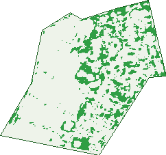
Green: 10 m cells where trees dominate, satellite 2021. Blue: water. The line is the suburb boundary.
| Canopy share, 1 m canopy height map, 2020 | 6.5% |
|---|---|
| Surveyed canopy, Greater Sydney aerial survey, 2019 | 8.6% |
| Land with trees, 10 m satellite map, 2021 | 14.1% |
Demographics
Unemployment 6.4% · Labour-force participation 62.6%
Population by age in Girraween
| 0-4 | 401 |
|---|---|
| 5-14 | 1,259 |
| 15-19 | 300 |
| 20-24 | 257 |
| 25-34 | 660 |
| 35-44 | 1,531 |
| 45-54 | 678 |
| 55-64 | 496 |
| 65-74 | 359 |
| 75-84 | 208 |
| 85+ | 103 |
Dwelling types in Girraween
| House | 871 |
|---|---|
| Townhouse | 887 |
| Apartment | 147 |
| Other | 0 |
Households by weekly income in Girraween
| <$650 | 225 |
|---|---|
| $650-1,499 | 341 |
| $1,500-2,999 | 554 |
| $3,000+ | 687 |
Top ancestries in Girraween
| Indian | 2,241 |
|---|---|
| Other | 2,170 |
| English | 545 |
| Australian | 512 |
| Ancestry NS | 282 |
| Chinese | 241 |
Housing tenure in Girraween
| Owned | 413 |
|---|---|
| Mortgage | 817 |
| Rented | 636 |
| Other | 10 |
Cars per household in Girraween
| 0 | 148 |
|---|---|
| 1 | 877 |
| 2 | 649 |
| 3 | 134 |
| 4+ | 68 |
Commute to work in Girraween
| Car | 886 |
|---|---|
| Train | 128 |
| Bus | 10 |
| Tram/ferry | 0 |
| Walked | 24 |
| Bicycle | 3 |
| Home | 1,255 |
Top countries of birth in Girraween
| India | 2,183 |
|---|---|
| Sri Lanka | 621 |
| Malta | 123 |
| China | 116 |
| New Zealand | 68 |
| Nepal | 58 |
Languages used at home in Girraween
| Tamil | 1,290 |
|---|---|
| Gujarati | 624 |
| Hindi | 460 |
| Malayalam | 208 |
| Punjabi | 153 |
| Arabic | 122 |
Birds & Wildlife Nearby
84,636 bird observations recorded near Girraween — most often seen:
- Rainbow Lorikeet (7,775)
- Noisy Miner (5,684)
- Common Myna (5,635)
- Australian Magpie (5,013)
- Spotted Turtle-dove (4,639)
- Sulphur-crested Cockatoo (4,537)
- Pied Currawong (4,045)
- Grey Butcherbird (3,510)
- Australian Raven (3,240)
- Red-whiskered Bulbul (3,144)
- Galah (3,056)
- Laughing Kookaburra (2,802)
- Common Starling (2,711)
Show all 30 birds recorded near Girraween
- House Sparrow (2,639)
- Red Wattlebird (2,470)
- Magpie-lark (2,273)
- Australian White Ibis (2,184)
- Crested Pigeon (2,143)
- Crimson Rosella (1,663)
- Eastern Spinebill (1,643)
- Silvereye (1,600)
- Spotted Pardalote (1,537)
- Rock Dove (1,536)
- Eastern Rainbow Lorikeet (1,525)
- Little Wattlebird (1,377)
- Southern Noisy Miner (1,374)
- Eastern Koel (1,324)
- Yellow-faced Honeyeater (1,230)
- Eastern Asian Spotted Dove (1,174)
- Eurasian Blackbird (1,153)
Sightings reported by observers, not a survey, so the counts show what people record rather than what lives here. Source: Atlas of Living Australia.
Nearby Suburbs
The closest suburbs to Girraween:
- Pendle Hill (1 km)
- Toongabbie (1.1 km)
- Old Toongabbie (2.3 km)
- Wentworthville (2.5 km)
- Constitution Hill (2.6 km)
- Seven Hills (2.6 km)
- Pemulwuy (2.7 km)
- Greystanes (2.8 km)
Embed this suburb
Add this free Girraween stat card to your own site — just copy the code:
Preview:
Cite this page
Quoting these figures? Copy the credit line:
Keep an eye on Girraween
One email when this data meaningfully changes — new census figures, prices, rankings. No spam, unsubscribe anytime.
Streets
- Amax Avenue (124)
- Andrew Place (38)
- Bando Road (66)
- Barnes Street (3)
- Carinya Road (200)
- Clayton Place (7)
- Edith Street (4)
- Gilba Road (227)
- Girraween Road (563)
- Great Western Highway (45)
- Hazel Street (27)
- Heather Street (35)
- Linlee Street (5)
- Lorne Street (1)
- Lyle Street (83)
- Magowar Road (198)
- Mandoon Road (161)
- Mansfield Street (20)
- Mardi Street (27)
- Masters Place (8)
- Maunder Avenue (73)
- Mia Mia Street (62)
- Mifsud Street (29)
- Normac Road (86)
- Oramzi Road (176)
- Palm Street (26)
- Pamela Place (18)
- Polo Crescent (15)
- Saxby Street (4)
- Targo Road (559)
- Teague Street (6)
- Toongabbie Road (58)
- Tungarra Road (226)
- Wiltona Place (24)