Galston NSW 2159
1,618 addresses · 44 streets
Berowra Electorate › Hornsby LGA › Galston · 28 km from Sydney
📦 Thinking of moving here? Read the Galston moving guide

Living Here
Galston is a suburb of New South Wales, home to about 3,195 people, with a median age of 46. The typical household earns around $2,295 a week, with median rent near $495 a week. Most homes are houses. About 81% of households own their home and 12% rent. Most workers drive to work. Common community backgrounds include English, Australian, Irish. On the ABS socio-economic scale it sits in decile 10 of 10 nationally — a relatively advantaged area.
Over time — Census 2001 → 2021
Dashed line: district figures for the Galston - Laughtondale statistical area (SA2), the smallest area the ABS published before 2011. Solid line: Galston itself.
Getting Around & Local Services
6 cafés & restaurants
2 pharmacies
3 doctors & medical clinics
1 dentist
2 libraries
1 post office
3 gyms & sports centres
1 dog park
1 bakery
1 butcher
1 plumber
1 place to stay
Getting around. Train station: Mount Colah, 6.3 km south-east · Bus interchange: Hillsbus Dural Depot, 5.5 km south · Airport: RAAF Base Richmond, 25 km west.
Socio-economic Standing
Deciles from 1 (lowest) to 10 (highest), against all Australian suburbs. The overall figure weighs advantage and disadvantage together; economic resources counts income and housing, and education & jobs counts qualifications and occupation. They often differ. Source: ABS SEIFA 2021.
Tree cover
🌳 Tree canopy: 62.2% share of land under canopy · satellite map, 2020
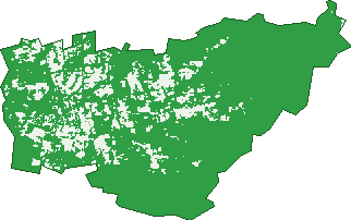
Green: 10 m cells where trees dominate, satellite 2021. Blue: water. The line is the suburb boundary.
| Canopy share, 1 m canopy height map, 2020 | 62.2% |
|---|---|
| Surveyed canopy, Greater Sydney aerial survey, 2019 | 60.5% |
| Land with trees, 10 m satellite map, 2021 | 85.6% |
Demographics
Unemployment 3.4% · Labour-force participation 58.7%
Population by age in Galston
| 0-4 | 129 |
|---|---|
| 5-14 | 432 |
| 15-19 | 236 |
| 20-24 | 153 |
| 25-34 | 253 |
| 35-44 | 327 |
| 45-54 | 443 |
| 55-64 | 443 |
| 65-74 | 362 |
| 75-84 | 264 |
| 85+ | 148 |
Dwelling types in Galston
| House | 896 |
|---|---|
| Townhouse | 72 |
| Apartment | 93 |
| Other | 4 |
Households by weekly income in Galston
| <$650 | 148 |
|---|---|
| $650-1,499 | 224 |
| $1,500-2,999 | 267 |
| $3,000+ | 376 |
Top ancestries in Galston
| English | 1,332 |
|---|---|
| Australian | 1,107 |
| Irish | 385 |
| Scottish | 343 |
| Other | 296 |
| Italian | 256 |
Housing tenure in Galston
| Owned | 473 |
|---|---|
| Mortgage | 381 |
| Rented | 131 |
| Other | 69 |
Cars per household in Galston
| 0 | 43 |
|---|---|
| 1 | 248 |
| 2 | 384 |
| 3 | 182 |
| 4+ | 199 |
Commute to work in Galston
| Car | 649 |
|---|---|
| Train | 5 |
| Bus | 0 |
| Tram/ferry | 0 |
| Walked | 27 |
| Bicycle | 0 |
| Home | 546 |
Top countries of birth in Galston
| England | 162 |
|---|---|
| South Africa | 47 |
| New Zealand | 43 |
| Italy | 42 |
| China | 30 |
| Germany | 21 |
Languages used at home in Galston
| Italian | 69 |
|---|---|
| Arabic | 49 |
| Mandarin | 36 |
| Greek | 16 |
| German | 15 |
| Cantonese | 12 |
Birds & Wildlife Nearby
7,965 bird observations recorded near Galston — most often seen:
- Rainbow Lorikeet (531)
- Laughing Kookaburra (496)
- Noisy Miner (460)
- Sulphur-crested Cockatoo (378)
- Magpie-lark (345)
- Australian Magpie (343)
- Australian Wood Duck (335)
- Common Myna (314)
- Eastern Rosella (291)
- Yellow-faced Honeyeater (291)
- Eastern Yellow Robin (278)
- Pacific Black Duck (268)
- Dusky Moorhen (266)
Show all 30 birds recorded near Galston
- Eastern Spinebill (253)
- Superb Fairy-wren (251)
- Welcome Swallow (236)
- Australian King-parrot (233)
- Crested Pigeon (221)
- Grey Butcherbird (207)
- Little Wattlebird (202)
- Masked Lapwing (198)
- Galah (182)
- Wonga Pigeon (181)
- Crimson Rosella (179)
- Eastern Whipbird (176)
- Australasian Purple Swamphen (172)
- Eurasian Coot (171)
- Pied Currawong (171)
- Australian Raven (168)
- Grey Fantail (168)
Sightings reported by observers, not a survey, so the counts show what people record rather than what lives here. Source: Atlas of Living Australia.
Nearby Suburbs
The closest suburbs to Galston:
- Arcadia (3.4 km)
- Middle Dural (3.5 km)
- Hornsby Heights (4.7 km)
- Dural (5.4 km)
- Berrilee (5.9 km)
- Mount Colah (6.3 km)
- Fiddletown (6.4 km)
- Kenthurst (6.5 km)
Embed this suburb
Add this free Galston stat card to your own site — just copy the code:
Preview:
Cite this page
Quoting these figures? Copy the credit line:
Keep an eye on Galston
One email when this data meaningfully changes — new census figures, prices, rankings. No spam, unsubscribe anytime.
Streets
- Arcadia Road (114)
- Bayfield Road (24)
- Belbowrie Close (21)
- Bevans Road (9)
- Calderwood Road (29)
- Carrs Road (12)
- Chadd Street (10)
- Crosslands Road (71)
- Crusader Road (10)
- Devon Place (10)
- Fishburns Road (17)
- Forest Place (21)
- Galston Road (567)
- Gardiner Road (14)
- Gartung Road (11)
- Glen Street (45)
- Gribbenmount Road (3)
- Griffith Close (14)
- Hakea Crescent (36)
- Halls Road (9)
- Hansen Avenue (35)
- Johnson Road (39)
- Karalee Road (14)
- Knights Road (82)
- Lackenwood Crescent (22)
- Mansfield Road (41)
- Martin Road (2)
- Matthew Close (13)
- Mcalister Road (7)
- Megan Road (12)
- Mid Dural Road (39)
- Nancy Place (65)
- Pine Valley Road (15)
- Radnor Road (38)
- Reynolds Place (5)
- Sallaway Road (11)
- School Road (16)
- Smalls Road (1)
- Sylvan Street (50)
- The Glade (19)
- The Knoll (6)
- Thomas Road (20)
- Towner Road (13)
- Treelands Close (6)