Kenthurst NSW 2156
2,058 addresses · 93 streets
Berowra Electorate › The Hills Shire LGA › Kenthurst · 32 km from Sydney
📦 Thinking of moving here? Read the Kenthurst moving guide

Living Here
Kenthurst is a suburb of New South Wales, home to about 5,313 people, with a median age of 44. The typical household earns around $3,061 a week, with median rent near $550 a week. Most homes are houses. About 88% of households own their home and 10% rent. Most workers drive to work. Common community backgrounds include English, Australian, Irish. On the ABS socio-economic scale it sits in decile 10 of 10 nationally — a relatively advantaged area.
Over time — Census 2001 → 2021
Dashed line: district figures for the Dural - Kenthurst - Wisemans Ferry statistical area (SA2), the smallest area the ABS published before 2011. Solid line: Kenthurst itself.
Getting Around & Local Services
2 cafés & restaurants
1 supermarket
1 pharmacy
2 libraries
1 post office
1 service station
1 butcher
1 hairdresser
1 beauty salon
Getting around. Train station: Schofields, 11.5 km south-west · Metro station: Rouse Hill, 6.8 km south-west · Bus interchange: Hillsbus Dural Depot, 6.7 km south-east · Airport: RAAF Base Richmond, 18.9 km west.
Socio-economic Standing
Deciles from 1 (lowest) to 10 (highest), against all Australian suburbs. The overall figure weighs advantage and disadvantage together; economic resources counts income and housing, and education & jobs counts qualifications and occupation. They often differ. Source: ABS SEIFA 2021.
Tree cover
🌳 Tree canopy: 57.4% share of land under canopy · satellite map, 2020
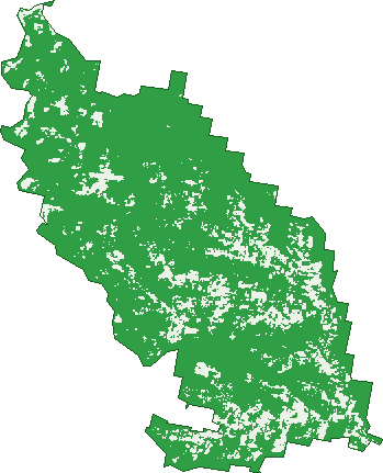
Green: 10 m cells where trees dominate, satellite 2021. Blue: water. The line is the suburb boundary.
| Canopy share, 1 m canopy height map, 2020 | 57.4% |
|---|---|
| Surveyed canopy, Greater Sydney aerial survey, 2019 | 56.3% |
| Land with trees, 10 m satellite map, 2021 | 85.1% |
Demographics
Unemployment 3.1% · Labour-force participation 63.5%
Population by age in Kenthurst
| 0-4 | 211 |
|---|---|
| 5-14 | 752 |
| 15-19 | 441 |
| 20-24 | 376 |
| 25-34 | 409 |
| 35-44 | 507 |
| 45-54 | 848 |
| 55-64 | 722 |
| 65-74 | 613 |
| 75-84 | 338 |
| 85+ | 94 |
Dwelling types in Kenthurst
| House | 1,488 |
|---|---|
| Townhouse | 32 |
| Apartment | 32 |
| Other | 0 |
Households by weekly income in Kenthurst
| <$650 | 135 |
|---|---|
| $650-1,499 | 232 |
| $1,500-2,999 | 339 |
| $3,000+ | 740 |
Top ancestries in Kenthurst
| English | 1,798 |
|---|---|
| Australian | 1,786 |
| Other | 558 |
| Irish | 534 |
| Italian | 519 |
| Scottish | 445 |
Housing tenure in Kenthurst
| Owned | 749 |
|---|---|
| Mortgage | 602 |
| Rented | 150 |
| Other | 35 |
Cars per household in Kenthurst
| 0 | 18 |
|---|---|
| 1 | 177 |
| 2 | 542 |
| 3 | 310 |
| 4+ | 489 |
Commute to work in Kenthurst
| Car | 1,178 |
|---|---|
| Train | 0 |
| Bus | 5 |
| Tram/ferry | 0 |
| Walked | 37 |
| Bicycle | 0 |
| Home | 966 |
Top countries of birth in Kenthurst
| England | 170 |
|---|---|
| China | 102 |
| Italy | 83 |
| New Zealand | 76 |
| Lebanon | 58 |
| India | 51 |
Languages used at home in Kenthurst
| Arabic | 118 |
|---|---|
| Mandarin | 115 |
| Italian | 111 |
| Punjabi | 32 |
| Serbian | 32 |
| Cantonese | 31 |
Birds & Wildlife Nearby
11,249 bird observations recorded near Kenthurst — most often seen:
- Rainbow Lorikeet (646)
- Laughing Kookaburra (604)
- Yellow-faced Honeyeater (590)
- Noisy Miner (515)
- Eastern Spinebill (440)
- Sulphur-crested Cockatoo (425)
- Superb Fairy-wren (425)
- Eastern Yellow Robin (423)
- Eastern Whipbird (408)
- Magpie-lark (401)
- Lewin's Honeyeater (395)
- Common Bronzewing (394)
- Bell Miner (371)
Show all 30 birds recorded near Kenthurst
- Grey Butcherbird (370)
- Spotted Pardalote (366)
- Common Myna (359)
- Little Wattlebird (345)
- Grey Fantail (344)
- Australian Magpie (341)
- Australian Raven (336)
- Australian Wood Duck (324)
- Australian King-parrot (316)
- Eastern Rosella (296)
- Wonga Pigeon (277)
- Red-browed Finch (276)
- Crimson Rosella (275)
- Grey Shrike-thrush (264)
- Black-faced Cuckoo-shrike (253)
- Pied Currawong (236)
- Brown Cuckoo-dove (234)
Sightings reported by observers, not a survey, so the counts show what people record rather than what lives here. Source: Atlas of Living Australia.
Nearby Suburbs
The closest suburbs to Kenthurst:
- Annangrove (3.1 km)
- Middle Dural (3.7 km)
- North Kellyville (4.6 km)
- Nelson (5.7 km)
- Glenhaven (6 km)
- Beaumont Hills (6.1 km)
- Kellyville (6.2 km)
- Dural (6.3 km)
Embed this suburb
Add this free Kenthurst stat card to your own site — just copy the code:
Preview:
Cite this page
Quoting these figures? Copy the credit line:
Keep an eye on Kenthurst
One email when this data meaningfully changes — new census figures, prices, rankings. No spam, unsubscribe anytime.
Streets
- Alicia Place (5)
- Angus Road (3)
- Annangrove Road (116)
- Ascot Road (19)
- Ashwood Road (9)
- Aston Road (6)
- Banksia Place (5)
- Bannerman Road (26)
- Binalong Road (24)
- Bloodwood Place (14)
- Blue Gum Road (9)
- Bower Bird Court (10)
- Budin Road (7)
- Burrell Road (16)
- Bush Road (1)
- Bushland Place (9)
- Cadwells Road (35)
- Campbell Road (38)
- Clarke Way (12)
- Colbran Avenue (51)
- Coolalie Place (10)
- Coppertail Place (6)
- Denham Road (10)
- Dobell Place (8)
- Dole Place (2)
- Dural Street (8)
- Ellendale Road (15)
- Emperor Place (29)
- Farm Road (13)
- Fuggles Road (35)
- Gibbs Road (10)
- Goodier Place (7)
- Grevillea Place (9)
- Griffin Place (6)
- Gundawarra Place (4)
- Hafey Road (11)
- Hazeldean Place (15)
- Hidden Valley Lane (8)
- Hilton Place (10)
- Imhoff Place (6)
- Ivy Place (8)
- Jefferson Grove (11)
- Johnson Avenue (15)
- Jones Road (115)
- Kalang Road (7)
- Karma Grove (5)
- Kemp Place (1)
- Kenthurst Road (207)
- Lang Road (24)
- Lawrence Road (23)
- Lisbon Road (11)
- Logie Road (8)
- Lukas Avenue (16)
- Lyrebird Court (13)
- Marieba Road (29)
- Mcclymonts Road (24)
- Miller Road (3)
- Mitchell Place (8)
- Murray Park Road (11)
- Nelson Street (20)
- Nicholii Place (12)
- Nolland Place (8)
- Nyari Road (24)
- Oakridge Place (7)
- Orana Road (32)
- Orange Grove (4)
- Pamela Place (8)
- Park Road (26)
- Parkcrest Place (18)
- Pitt Town Road (283)
- Porters Road (166)
- Raym Road (22)
- Robson Road (17)
- Roughley Road (13)
- Sagars Road (1)
- Sandpiper Place (19)
- Sandy Place (4)
- Sedger Road (38)
- Seville Place (5)
- Sildor Court (6)
- Smerdon Place (6)
- Sorbello Place (8)
- Strath Place (14)
- Tallawung Place (8)
- Tanilba Place (5)
- Thiele Road (7)
- Volunteer Road (33)
- Wandarri Road (15)
- Wattlebird Close (6)
- Whitehall Road (22)
- Wrench Place (7)
- Yarrabin Road (16)
- Yeranda Place (2)