Cabramatta NSW 2166
9,758 addresses · 105 streets
Fowler Electorate › Fairfield LGA › Cabramatta · 25 km from Sydney
📦 Thinking of moving here? Read the Cabramatta moving guide

Living Here
A vibrant, highly multicultural centre in south-western Sydney famous for its Vietnamese food and markets, Cabramatta is busy and rail-connected. Households average 3.0 people and the median age is 40. Median household income is $1,184 a week, with rent around $330.
Cabramatta is a suburb of New South Wales, home to about 21,142 people, with a median age of 40. The typical household earns around $1,184 a week, with median rent near $330 a week. Most homes are houses. About 50% of households own their home and 49% rent. Most workers drive to work. Common community backgrounds include Vietnamese, Chinese, Ancestry NS. On the ABS socio-economic scale it sits in decile 1 of 10 nationally — a more disadvantaged area.
Over time — Census 2001 → 2021
Dashed line: district figures for the Cabramatta - Lansvale statistical area (SA2), the smallest area the ABS published before 2011. Solid line: Cabramatta itself.
Getting Around & Local Services
3 physiotherapists
3 childcare & kindergartens
2 electricians
Getting around. Train station: Cabramatta, 350 m east · Bus interchange: Bankstown Station, 9.5 km east · Airport: Bankstown Airport, 6.3 km south-east.
Socio-economic Standing
Deciles from 1 (lowest) to 10 (highest), against all Australian suburbs. The overall figure weighs advantage and disadvantage together; economic resources counts income and housing, and education & jobs counts qualifications and occupation. They often differ. Source: ABS SEIFA 2021.
Tree cover
🌳 Tree canopy: 11.1% share of land under canopy · satellite map, 2020
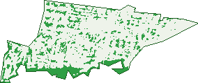
Green: 10 m cells where trees dominate, satellite 2021. Blue: water. The line is the suburb boundary.
| Canopy share, 1 m canopy height map, 2020 | 11.1% |
|---|---|
| Surveyed canopy, Greater Sydney aerial survey, 2019 | 11.9% |
| Land with trees, 10 m satellite map, 2021 | 15.9% |
Demographics
Unemployment 10.9% · Labour-force participation 40.5%
Population by age in Cabramatta
| 0-4 | 934 |
|---|---|
| 5-14 | 2,262 |
| 15-19 | 1,350 |
| 20-24 | 1,639 |
| 25-34 | 2,906 |
| 35-44 | 2,513 |
| 45-54 | 3,047 |
| 55-64 | 2,987 |
| 65-74 | 2,010 |
| 75-84 | 922 |
| 85+ | 575 |
Dwelling types in Cabramatta
| House | 2,528 |
|---|---|
| Townhouse | 1,435 |
| Apartment | 2,519 |
| Other | 10 |
Households by weekly income in Cabramatta
| <$650 | 1,451 |
|---|---|
| $650-1,499 | 2,292 |
| $1,500-2,999 | 1,636 |
| $3,000+ | 697 |
Top ancestries in Cabramatta
| Vietnamese | 7,995 |
|---|---|
| Chinese | 5,891 |
| Other | 3,943 |
| Ancestry NS | 2,288 |
| Australian | 1,143 |
| English | 1,106 |
Housing tenure in Cabramatta
| Owned | 1,812 |
|---|---|
| Mortgage | 1,328 |
| Rented | 3,073 |
| Other | 123 |
Cars per household in Cabramatta
| 0 | 1,159 |
|---|---|
| 1 | 2,783 |
| 2 | 1,551 |
| 3 | 539 |
| 4+ | 321 |
Commute to work in Cabramatta
| Car | 3,557 |
|---|---|
| Train | 319 |
| Bus | 42 |
| Tram/ferry | 0 |
| Walked | 240 |
| Bicycle | 18 |
| Home | 1,001 |
Top countries of birth in Cabramatta
| Vietnam | 7,944 |
|---|---|
| Cambodia | 1,687 |
| China | 849 |
| Thailand | 436 |
| Malaysia | 247 |
| New Zealand | 208 |
Languages used at home in Cabramatta
| Vietnamese | 9,144 |
|---|---|
| Cantonese | 2,077 |
| Khmer | 1,519 |
| Mandarin | 1,034 |
| Thai | 358 |
| Serbian | 302 |
Birds & Wildlife Nearby
35,429 bird observations recorded near Cabramatta — most often seen:
- Australian White Ibis (3,008)
- Rainbow Lorikeet (2,550)
- Australian Magpie (2,047)
- Noisy Miner (2,036)
- Common Myna (1,712)
- Australian Raven (1,626)
- Sulphur-crested Cockatoo (1,457)
- Magpie-lark (1,437)
- Willie Wagtail (1,244)
- Rock Dove (1,173)
- Dusky Moorhen (1,172)
- Superb Fairy-wren (1,155)
- Spotted Turtle-dove (1,148)
Show all 30 birds recorded near Cabramatta
- Pacific Black Duck (1,103)
- Welcome Swallow (1,084)
- Pied Currawong (1,082)
- Crested Pigeon (989)
- Common Starling (959)
- Australian Wood Duck (947)
- Red Wattlebird (908)
- Grey Butcherbird (797)
- Red-whiskered Bulbul (777)
- Masked Lapwing (714)
- Galah (707)
- Bell Miner (637)
- Black-faced Cuckoo-shrike (634)
- Eurasian Coot (593)
- New Holland Honeyeater (593)
- Laughing Kookaburra (578)
- Red-browed Finch (562)
Sightings reported by observers, not a survey, so the counts show what people record rather than what lives here. Source: Atlas of Living Australia.
Nearby Suburbs
The closest suburbs to Cabramatta:
- Canley Vale (1.3 km)
- Canley Heights (1.7 km)
- Cabramatta West (2 km)
- Warwick Farm (2.1 km)
- Lansvale (2.2 km)
- Carramar (2.8 km)
- Mount Pritchard (3.1 km)
- Fairfield (3.1 km)
Embed this suburb
Add this free Cabramatta stat card to your own site — just copy the code:
Preview:
Cite this page
Quoting these figures? Copy the credit line:
Keep an eye on Cabramatta
One email when this data meaningfully changes — new census figures, prices, rankings. No spam, unsubscribe anytime.
Streets
- Acacia Street (150)
- Aladore Avenue (20)
- Albert Street (54)
- Alick Street (70)
- Alison Close (10)
- Alphil Avenue (14)
- Angelina Crescent (47)
- Antonietta Street (33)
- Arthur Street (92)
- Astrid Close (7)
- Bareena Street (2)
- Bartley Street (4)
- Begonia Avenue (31)
- Belvedere Arcade (11)
- Blair Place (10)
- Bolivia Street (51)
- Booyong Street (46)
- Boundary Lane (33)
- Bowden Street (70)
- Bridge Street (152)
- Brigalow Street (1)
- Broad Street (59)
- Broomfield Street (205)
- Burraneer Bay Road (1)
- Cabramatta Road E (239)
- Cabramatta Road W (325)
- Carabeen Street (53)
- Chadderton Street (80)
- Church Street (241)
- Coventry Road (64)
- Crabb Place (20)
- Cumberland Street (259)
- Curtin Street (101)
- Dutton Lane (55)
- Eurabbie Street (55)
- Eve Court (8)
- Fairview Road (47)
- Fisher Street (154)
- Freedom Plaza (16)
- Gidgee Street (57)
- Gilbert Street (182)
- Giles Place (6)
- Gilmore Street (25)
- Gladstone Street (89)
- Gowrie Place (16)
- Grace Avenue (29)
- Grant Avenue (28)
- Hill Street (448)
- Huber Avenue (43)
- Hughes Street (787)
- Huie Street (7)
- Hume Highway (62)
- Huon Street (55)
- Jacquie Street (41)
- Jasmine Crescent (95)
- John Street (925)
- Joseph Street (27)
- Judith Avenue (47)
- Junction Street (37)
- Kauri Street (49)
- Keryn Place (11)
- Kim Close (15)
- Kurrajong Street (75)
- Lalor Street (4)
- Lasa Street (41)
- Levuka Street (76)
- Links Avenue (46)
- Liverpool Street (50)
- Loloma Street (32)
- Longfield Street (722)
- Lovoni Street (82)
- Lunn Court (14)
- Lyons Avenue (24)
- Mallee Street (16)
- Maple Street (34)
- Mcburney Road (957)
- Melville Avenue (18)
- Myall Street (139)
- Nance Avenue (13)
- National Street (79)
- Old Liverpool Road (1)
- Orange Grove Road (21)
- Panorama Avenue (12)
- Park Road (278)
- Phillip Avenue (30)
- Prout Street (31)
- Railway Parade (247)
- Ralph Street (29)
- Roebuck Street (41)
- Ryan Avenue (10)
- Slim Place (9)
- Smiths Avenue (82)
- Sonja Close (9)
- St Johns Road (239)
- Stafford Street (18)
- Stonehaven Parade (30)
- Sussex Street (65)
- Towers Street (13)
- Vale Street (83)
- Vera Court (10)
- View Street (8)
- Wadds Avenue (14)
- Warwick Avenue (37)
- Wendy Close (20)
- Woods Avenue (28)