Mount Pritchard NSW 2170
3,825 addresses · 109 streets
Fowler Electorate › Fairfield LGA › Mount Pritchard · 29 km from Sydney
📦 Thinking of moving here? Read the Mount Pritchard moving guide

Living Here
Mount Pritchard is a suburb of New South Wales, home to about 10,426 people, with a median age of 36. The typical household earns around $1,396 a week, with median rent near $380 a week. Most homes are houses. About 64% of households own their home and 35% rent. Most workers drive to work. Common community backgrounds include Vietnamese, Australian, English. On the ABS socio-economic scale it sits in decile 1 of 10 nationally — a more disadvantaged area.
Over time — Census 2001 → 2021
Dashed line: district figures for the Cabramatta West - Mount Pritchard statistical area (SA2), the smallest area the ABS published before 2011. Solid line: Mount Pritchard itself.
Getting Around & Local Services
11 doctors & medical clinics
2 physiotherapists
3 childcare & kindergartens
1 playground
3 electricians
Getting around. Train station: Warwick Farm, 3.2 km east · Airport: Bankstown Airport, 8.7 km east.
Socio-economic Standing
Deciles from 1 (lowest) to 10 (highest), against all Australian suburbs. The overall figure weighs advantage and disadvantage together; economic resources counts income and housing, and education & jobs counts qualifications and occupation. They often differ. Source: ABS SEIFA 2021.
Tree cover
🌳 Tree canopy: 9% share of land under canopy · satellite map, 2020
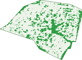
Green: 10 m cells where trees dominate, satellite 2021. Blue: water. The line is the suburb boundary.
| Canopy share, 1 m canopy height map, 2020 | 9.0% |
|---|---|
| Land with trees, 10 m satellite map, 2021 | 19.5% |
Demographics
Unemployment 7.7% · Labour-force participation 44.2%
Population by age in Mount Pritchard
| 0-4 | 607 |
|---|---|
| 5-14 | 1,461 |
| 15-19 | 771 |
| 20-24 | 736 |
| 25-34 | 1,384 |
| 35-44 | 1,308 |
| 45-54 | 1,340 |
| 55-64 | 1,318 |
| 65-74 | 857 |
| 75-84 | 478 |
| 85+ | 169 |
Dwelling types in Mount Pritchard
| House | 2,679 |
|---|---|
| Townhouse | 288 |
| Apartment | 106 |
| Other | 0 |
Households by weekly income in Mount Pritchard
| <$650 | 617 |
|---|---|
| $650-1,499 | 916 |
| $1,500-2,999 | 886 |
| $3,000+ | 471 |
Top ancestries in Mount Pritchard
| Other | 2,375 |
|---|---|
| Vietnamese | 2,185 |
| Australian | 1,324 |
| English | 1,198 |
| Ancestry NS | 1,015 |
| Chinese | 909 |
Housing tenure in Mount Pritchard
| Owned | 875 |
|---|---|
| Mortgage | 1,039 |
| Rented | 1,039 |
| Other | 52 |
Cars per household in Mount Pritchard
| 0 | 289 |
|---|---|
| 1 | 992 |
| 2 | 981 |
| 3 | 448 |
| 4+ | 303 |
Commute to work in Mount Pritchard
| Car | 1,904 |
|---|---|
| Train | 35 |
| Bus | 24 |
| Tram/ferry | 0 |
| Walked | 20 |
| Bicycle | 0 |
| Home | 704 |
Top countries of birth in Mount Pritchard
| Vietnam | 1,654 |
|---|---|
| Iraq | 345 |
| Cambodia | 301 |
| New Zealand | 202 |
| Lebanon | 200 |
| Italy | 165 |
Languages used at home in Mount Pritchard
| Vietnamese | 2,373 |
|---|---|
| Arabic | 855 |
| Serbian | 491 |
| Khmer | 311 |
| Cantonese | 237 |
| Italian | 214 |
Birds & Wildlife Nearby
25,288 bird observations recorded near Mount Pritchard — most often seen:
- Rainbow Lorikeet (2,005)
- Australian Magpie (1,618)
- Noisy Miner (1,498)
- Australian White Ibis (1,481)
- Common Myna (1,324)
- Australian Raven (1,142)
- Sulphur-crested Cockatoo (1,048)
- Magpie-lark (1,030)
- Rock Dove (1,022)
- Spotted Turtle-dove (883)
- Willie Wagtail (863)
- Welcome Swallow (802)
- Common Starling (799)
Show all 30 birds recorded near Mount Pritchard
- Crested Pigeon (752)
- Dusky Moorhen (747)
- Pacific Black Duck (744)
- Pied Currawong (719)
- Superb Fairy-wren (703)
- Australian Wood Duck (625)
- Masked Lapwing (615)
- Red Wattlebird (587)
- Red-whiskered Bulbul (587)
- Grey Butcherbird (559)
- Galah (527)
- Birds (476)
- House Sparrow (447)
- Black-faced Cuckoo-shrike (437)
- Eurasian Blackbird (437)
- New Holland Honeyeater (431)
- White-plumed Honeyeater (380)
Sightings reported by observers, not a survey, so the counts show what people record rather than what lives here. Source: Atlas of Living Australia.
Nearby Suburbs
The closest suburbs to Mount Pritchard:
- Ashcroft (1.4 km)
- Heckenberg (1.4 km)
- Cabramatta West (1.5 km)
- Bonnyrigg (1.6 km)
- Sadleir (2 km)
- St Johns Park (2.2 km)
- Busby (2.3 km)
- Warwick Farm (2.7 km)
Embed this suburb
Add this free Mount Pritchard stat card to your own site — just copy the code:
Preview:
Cite this page
Quoting these figures? Copy the credit line:
Keep an eye on Mount Pritchard
One email when this data meaningfully changes — new census figures, prices, rankings. No spam, unsubscribe anytime.
Streets
- Amadio Place (6)
- Anderson Avenue (227)
- Ann Crescent (6)
- Antill Place (8)
- Antill Road (18)
- Ashton Place (10)
- Bainton Road (18)
- Bannister Place (25)
- Barook Place (14)
- Bell Place (7)
- Belvedere Street (30)
- Benjamin Road (41)
- Bexley Street (4)
- Bindea Street (22)
- Bolton Avenue (6)
- Brier Place (11)
- Brownlee Place (7)
- Cabramatta Road W (117)
- Cherry Street (9)
- Conder Avenue (19)
- Cox Place (9)
- Crayford Crescent (71)
- Dadswell Place (10)
- Dargie Street (22)
- Dartford Street (36)
- David Street (36)
- Dawes Street (4)
- Dawn Avenue (6)
- Dobell Street (25)
- Dorothy Street (8)
- Drysdale Road (14)
- Edna Avenue (84)
- Elizabeth Drive (173)
- Evans Place (6)
- Exhibition Parade (43)
- Farningham Street (14)
- Fig Place (6)
- Finlay Avenue (12)
- Fiona Street (41)
- Florence Street (55)
- Florey Crescent (21)
- Floyd Place (18)
- Friend Way (16)
- Garden Street (21)
- Glendale Avenue (14)
- Govett Street (14)
- Grainger Avenue (85)
- Gruner Place (11)
- Haig Street (11)
- Hamel Road (77)
- Heinze Avenue (14)
- Hemphill Avenue (230)
- Hilltop Avenue (33)
- Hitter Avenue (17)
- Hoff Street (5)
- Horton Street (14)
- Houston Place (5)
- Humphries Road (29)
- Hutchens Avenue (34)
- Jones Place (2)
- Joy Street (20)
- Kelly Place (10)
- Kewin Avenue (15)
- Lambert Place (13)
- Lena Street (13)
- Leo Street (11)
- Lindsay Place (8)
- Lookout Drive (41)
- Maggiotto Place (38)
- Malcolm Avenue (44)
- Matheson Avenue (24)
- Mccubbin Place (10)
- Meadows Road (250)
- Meldrum Avenue (79)
- Miller Place (9)
- Mountain Crescent (9)
- Nolan Place (14)
- North Liverpool Road (94)
- O'shannassy Street (29)
- Oak Place (7)
- Oliphant Street (86)
- Parkside Place (6)
- Patricia Avenue (19)
- Phyllis Street (84)
- Pritchard Street (100)
- Rachel Crescent (18)
- Reservoir Road (125)
- Roberts Avenue (6)
- Robyn Crescent (8)
- Roma Avenue (35)
- Rose Avenue (48)
- Russell Street (49)
- Sidon Place (6)
- South Pacific Avenue (61)
- Streeton Avenue (14)
- Swanley Street (14)
- Tedwin Street (21)
- Thorn Place (10)
- Tobys Boulevard (54)
- Townview Road (208)
- Tresalam Street (30)
- Valerie Street (9)
- Verbrugghen Place (14)
- Verona Avenue (13)
- Wakelin Avenue (23)
- Wallace Place (11)
- Welling Place (11)
- Winstanley Place (12)
- Young Street (41)