Belrose NSW 2085
5,483 addresses · 150 streets
Mackellar Electorate › Northern Beaches LGA › Belrose · 16 km from Sydney
📦 Thinking of moving here? Read the Belrose moving guide

Living Here
Belrose is a suburb of New South Wales, home to about 8,726 people, with a median age of 46. The typical household earns around $2,598 a week, with median rent near $890 a week. Most homes are houses. About 85% of households own their home and 12% rent. Most workers work from home. Common community backgrounds include English, Australian, Irish. On the ABS socio-economic scale it sits in decile 10 of 10 nationally — a relatively advantaged area.
Over time — Census 2001 → 2021
Dashed line: district figures for the Frenchs Forest - Belrose statistical area (SA2), the smallest area the ABS published before 2011. Solid line: Belrose itself.
Getting Around & Local Services
7 supermarkets
3 pharmacies
2 physiotherapists
2 post offices
6 service stations
1 playground
2 bakeries
1 butcher
4 hairdressers
2 beauty salons
2 electricians
Getting around. Train station: Gordon, 6.6 km south-west · Bus interchange: Gordon Interchange, 6.6 km south-west · Airport: Rose Bay Seaplane Base, 16.6 km south.
Socio-economic Standing
Deciles from 1 (lowest) to 10 (highest), against all Australian suburbs. The overall figure weighs advantage and disadvantage together; economic resources counts income and housing, and education & jobs counts qualifications and occupation. They often differ. Source: ABS SEIFA 2021.
Tree cover
🌳 Tree canopy: 59.2% share of land under canopy · satellite map, 2020
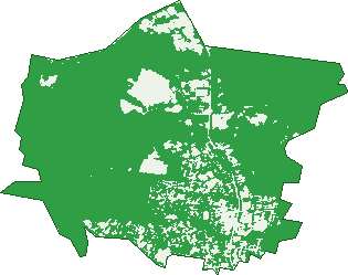
Green: 10 m cells where trees dominate, satellite 2021. Blue: water. The line is the suburb boundary.
| Canopy share, 1 m canopy height map, 2020 | 59.2% |
|---|---|
| Surveyed canopy, Greater Sydney aerial survey, 2019 | 53.7% |
| Land with trees, 10 m satellite map, 2021 | 86.1% |
Demographics
Unemployment 2.9% · Labour-force participation 58.6%
Population by age in Belrose
| 0-4 | 364 |
|---|---|
| 5-14 | 1,237 |
| 15-19 | 612 |
| 20-24 | 461 |
| 25-34 | 463 |
| 35-44 | 961 |
| 45-54 | 1,375 |
| 55-64 | 947 |
| 65-74 | 894 |
| 75-84 | 953 |
| 85+ | 462 |
Dwelling types in Belrose
| House | 2,310 |
|---|---|
| Townhouse | 277 |
| Apartment | 320 |
| Other | 0 |
Households by weekly income in Belrose
| <$650 | 339 |
|---|---|
| $650-1,499 | 553 |
| $1,500-2,999 | 627 |
| $3,000+ | 1,227 |
Top ancestries in Belrose
| English | 3,489 |
|---|---|
| Australian | 2,962 |
| Other | 1,240 |
| Irish | 989 |
| Scottish | 840 |
| Chinese | 486 |
Housing tenure in Belrose
| Owned | 1,267 |
|---|---|
| Mortgage | 1,174 |
| Rented | 336 |
| Other | 103 |
Cars per household in Belrose
| 0 | 109 |
|---|---|
| 1 | 874 |
| 2 | 1,222 |
| 3 | 427 |
| 4+ | 240 |
Commute to work in Belrose
| Car | 1,504 |
|---|---|
| Train | 3 |
| Bus | 52 |
| Tram/ferry | 0 |
| Walked | 23 |
| Bicycle | 13 |
| Home | 1,810 |
Top countries of birth in Belrose
| England | 614 |
|---|---|
| South Africa | 235 |
| China | 212 |
| New Zealand | 149 |
| Iran | 93 |
| India | 67 |
Languages used at home in Belrose
| Mandarin | 218 |
|---|---|
| Cantonese | 124 |
| Japanese | 79 |
| Italian | 76 |
| Spanish | 57 |
| Greek | 49 |
Birds & Wildlife Nearby
43,932 bird observations recorded near Belrose — most often seen:
- Rainbow Lorikeet (3,033)
- Silvereye (2,515)
- Australian Brush-turkey (2,391)
- Laughing Kookaburra (2,319)
- Sulphur-crested Cockatoo (2,221)
- Noisy Miner (2,191)
- Eastern Spinebill (2,028)
- Yellow-faced Honeyeater (1,924)
- Australian Magpie (1,756)
- White-cheeked Honeyeater (1,718)
- Pied Currawong (1,556)
- Little Wattlebird (1,539)
- Australian Raven (1,523)
Show all 30 birds recorded near Belrose
- Grey Butcherbird (1,315)
- Eastern Whipbird (1,230)
- Brown Thornbill (1,202)
- Red Wattlebird (1,180)
- Spotted Pardalote (1,169)
- New Holland Honeyeater (1,153)
- White-browed Scrubwren (1,145)
- Red-browed Finch (1,127)
- Eastern Yellow Robin (1,116)
- Variegated Fairy-wren (997)
- Masked Lapwing (878)
- Superb Fairy-wren (877)
- Welcome Swallow (836)
- Grey Fantail (832)
- Black-faced Cuckoo-shrike (798)
- Common Myna (683)
- Lewin's Honeyeater (680)
Sightings reported by observers, not a survey, so the counts show what people record rather than what lives here. Source: Atlas of Living Australia.
Nearby Suburbs
The closest suburbs to Belrose:
- Davidson (2.5 km)
- Frenchs Forest (2.7 km)
- Oxford Falls (3.7 km)
- Forestville (3.8 km)
- St Ives (4.6 km)
- East Killara (4.8 km)
- Terrey Hills (4.9 km)
- Beacon Hill (5 km)
Embed this suburb
Add this free Belrose stat card to your own site — just copy the code:
Preview:
Cite this page
Quoting these figures? Copy the credit line:
Keep an eye on Belrose
One email when this data meaningfully changes — new census figures, prices, rankings. No spam, unsubscribe anytime.
Streets
- Andove Street (32)
- Annette Place (9)
- Anoushka Place (21)
- Ashworth Avenue (99)
- Banyeena Place (11)
- Baringa Close (6)
- Belmount Place (4)
- Birrong Avenue (18)
- Birru Place (6)
- Brolga Place (9)
- Bundaleer Street (40)
- Burrswood Close (9)
- Caleyi Way (9)
- Calool Crescent (44)
- Camira Close (18)
- Castle Crescent (19)
- Challenger Drive (1)
- Charleroi Road (41)
- Chatham Close (8)
- Childs Circuit (76)
- Clwydon Close (6)
- Coachline Place (7)
- Coora Avenue (34)
- Corbett Place (17)
- Cotentin Road (31)
- Cotswold Close (10)
- Crozier Road (2)
- Curragundi Avenue (17)
- Dawes Road (407)
- Dell Street (1)
- Devere Avenue (18)
- Dindima Place (19)
- Dorset Close (16)
- Drew Place (16)
- Edgewood Place (19)
- Elm Avenue (61)
- Evelyn Place (9)
- Everton Road (12)
- Fiona Street (20)
- Forest Glen Crescent (38)
- Forest Way (1,291)
- Garigal Road (2)
- Glen Street (113)
- Glenrose Place (1)
- Haigh Avenue (118)
- Hakea Avenue (10)
- Hal Hammond Place (7)
- Hampden Street (8)
- Harst Place (11)
- Harstaf Close (10)
- Hawea Place (14)
- Henley Close (12)
- Hews Court (14)
- Hews Parade (60)
- High Valley Place (14)
- Hilversum Crescent (8)
- Hindson Place (7)
- Isla Place (10)
- Jilliby Place (5)
- Kapunda Place (24)
- Kapyong Street (19)
- Karalta Crescent (33)
- Karina Crescent (31)
- Kew Close (10)
- Knightsbridge Avenue (48)
- Kulalye Place (2)
- Kyeema Parade (15)
- Laurie Place (11)
- Linden Avenue (7)
- Lindrum Street (14)
- Lockhart Place (14)
- Lockwood Avenue (1)
- Lord Street (9)
- Loretta Place (12)
- Lowanna Street (26)
- Lyndale Place (14)
- Lyndhurst Way (7)
- Lynette Place (6)
- Madang Road (2)
- Maple Place (11)
- Marina Place (5)
- Marnoo Place (9)
- Merelyn Road (30)
- Meridian Close (12)
- Middle Harbour Place (10)
- Minna Close (17)
- Mona Vale Road (9)
- Morgan Road (226)
- Mulley Place (4)
- Munnumba Avenue (12)
- Muraban Place (5)
- Nabiac Avenue (10)
- Narabang Way (639)
- Neridah Avenue (54)
- Niangala Close (61)
- Niven Place (25)
- Northam Street (6)
- Nurragi Place (12)
- Nursery Place (9)
- Oates Place (3)
- Ocean View Way (9)
- Olga Place (5)
- Opala Street (18)
- Oxford Close (8)
- Palona Place (1)
- Paramount Close (13)
- Pembroke Place (23)
- Perentie Road (36)
- Pindrie Place (15)
- Prince Charles Road (21)
- Pringle Avenue (112)
- Pusan Place (14)
- Ralston Avenue (98)
- Rupari Place (16)
- Seaview Parade (31)
- Seeana Place (15)
- Simpson Street (20)
- Skene Place (11)
- Spence Place (11)
- St Andrews Close (11)
- St Annes Close (9)
- Stirling Place (18)
- Stratford Drive (20)
- Stratham Place (10)
- Stroud Place (18)
- Tanami Close (28)
- The Glade (7)
- The Grove (11)
- The Vale (5)
- Towarri Place (16)
- Trentbridge Road (60)
- Tudor Close (8)
- Turella Close (7)
- Undula Place (13)
- Vista Street (10)
- Waldon Road (5)
- Wallina Avenue (11)
- Wanaka Place (14)
- Wanniti Road (22)
- Wearden Road (23)
- Wentworth Place (12)
- William Lord Place (16)
- Willow Tree Crescent (54)
- Winani Close (4)
- Windrush Avenue (59)
- Wingara Grove (17)
- Wyatt Avenue (18)
- Yarrabin Street (56)
- Yerevan Place (7)
- Zieria Place (8)