Forestville NSW 2087
3,600 addresses · 95 streets
Mackellar Electorate › Northern Beaches LGA › Forestville · 12 km from Sydney
📦 Thinking of moving here? Read the Forestville moving guide

Living Here
Forestville is a suburb of New South Wales, home to about 8,659 people, with a median age of 43. The typical household earns around $2,507 a week, with median rent near $650 a week. Most homes are houses. About 77% of households own their home and 20% rent. Most workers work from home. Common community backgrounds include English, Australian, Irish. On the ABS socio-economic scale it sits in decile 10 of 10 nationally — a relatively advantaged area.
Over time — Census 2001 → 2021
Dashed line: district figures for the Forestville - Killarney Heights statistical area (SA2), the smallest area the ABS published before 2011. Solid line: Forestville itself.
Getting Around & Local Services
7 supermarkets
1 beach
10 doctors & medical clinics
11 childcare & kindergartens
2 playgrounds
2 butchers
2 electricians
Getting around. Train station: Roseville, 4.2 km south-west · Metro station: Chatswood, 5.1 km south-west · Bus interchange: Chatswood Transport Interchange, 5 km south-west · Ferry wharf: Manly Wharf, 8 km south-east · Airport: Rose Bay Seaplane Base, 13.1 km south.
Socio-economic Standing
Deciles from 1 (lowest) to 10 (highest), against all Australian suburbs. The overall figure weighs advantage and disadvantage together; economic resources counts income and housing, and education & jobs counts qualifications and occupation. They often differ. Source: ABS SEIFA 2021.
Tree cover
🌳 Tree canopy: 37.9% share of land under canopy · satellite map, 2020
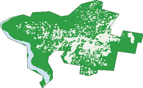
Green: 10 m cells where trees dominate, satellite 2021. Blue: water. The line is the suburb boundary.
| Canopy share, 1 m canopy height map, 2020 | 37.9% |
|---|---|
| Surveyed canopy, Greater Sydney aerial survey, 2019 | 46.7% |
| Land with trees, 10 m satellite map, 2021 | 80.9% |
Demographics
Unemployment 3.2% · Labour-force participation 60.2%
Population by age in Forestville
| 0-4 | 423 |
|---|---|
| 5-14 | 1,388 |
| 15-19 | 619 |
| 20-24 | 435 |
| 25-34 | 528 |
| 35-44 | 1,106 |
| 45-54 | 1,409 |
| 55-64 | 983 |
| 65-74 | 716 |
| 75-84 | 701 |
| 85+ | 352 |
Dwelling types in Forestville
| House | 2,326 |
|---|---|
| Townhouse | 380 |
| Apartment | 187 |
| Other | 0 |
Households by weekly income in Forestville
| <$650 | 412 |
|---|---|
| $650-1,499 | 508 |
| $1,500-2,999 | 630 |
| $3,000+ | 1,190 |
Top ancestries in Forestville
| English | 3,012 |
|---|---|
| Australian | 2,592 |
| Other | 1,619 |
| Irish | 884 |
| Scottish | 775 |
| Chinese | 760 |
Housing tenure in Forestville
| Owned | 1,140 |
|---|---|
| Mortgage | 1,067 |
| Rented | 566 |
| Other | 96 |
Cars per household in Forestville
| 0 | 198 |
|---|---|
| 1 | 979 |
| 2 | 1,148 |
| 3 | 331 |
| 4+ | 211 |
Commute to work in Forestville
| Car | 1,349 |
|---|---|
| Train | 10 |
| Bus | 87 |
| Tram/ferry | 0 |
| Walked | 57 |
| Bicycle | 6 |
| Home | 1,889 |
Top countries of birth in Forestville
| England | 461 |
|---|---|
| China | 257 |
| New Zealand | 174 |
| Hong Kong | 131 |
| South Africa | 126 |
| Japan | 97 |
Languages used at home in Forestville
| Cantonese | 279 |
|---|---|
| Mandarin | 239 |
| French | 193 |
| Japanese | 140 |
| Spanish | 89 |
| Italian | 60 |
Birds & Wildlife Nearby
85,301 bird observations recorded near Forestville — most often seen:
- Rainbow Lorikeet (8,388)
- Noisy Miner (7,175)
- Sulphur-crested Cockatoo (6,533)
- Laughing Kookaburra (5,755)
- Australian Magpie (4,892)
- Pied Currawong (4,787)
- Australian Raven (4,545)
- Grey Butcherbird (4,399)
- Australian Brush-turkey (3,799)
- Eastern Whipbird (3,393)
- Welcome Swallow (2,747)
- Silver Gull (2,635)
- Eastern Spinebill (1,911)
Show all 30 birds recorded near Forestville
- Red Wattlebird (1,854)
- Little Wattlebird (1,668)
- White-browed Scrubwren (1,657)
- Australian King-parrot (1,608)
- Spotted Pardalote (1,608)
- Brown Thornbill (1,568)
- Channel-billed Cuckoo (1,448)
- Eastern Yellow Robin (1,416)
- White-cheeked Honeyeater (1,412)
- Crimson Rosella (1,367)
- Yellow-faced Honeyeater (1,321)
- Silvereye (1,308)
- Variegated Fairy-wren (1,307)
- Rock Dove (1,303)
- Masked Lapwing (1,234)
- Common Myna (1,137)
- Crested Pigeon (1,126)
Sightings reported by observers, not a survey, so the counts show what people record rather than what lives here. Source: Atlas of Living Australia.
Nearby Suburbs
The closest suburbs to Forestville:
- Killarney Heights (1.6 km)
- Frenchs Forest (2 km)
- Roseville Chase (2.2 km)
- East Lindfield (2.4 km)
- Davidson (2.7 km)
- Castle Cove (2.8 km)
- East Killara (3.1 km)
- Middle Cove (3.6 km)
Embed this suburb
Add this free Forestville stat card to your own site — just copy the code:
Preview:
Cite this page
Quoting these figures? Copy the credit line:
Keep an eye on Forestville
One email when this data meaningfully changes — new census figures, prices, rankings. No spam, unsubscribe anytime.
Streets
- Aldinga Place (62)
- Alkoomie Avenue (22)
- Altona Avenue (44)
- Angel Place (9)
- Angophora Crescent (50)
- Apara Street (14)
- Arthur Street (137)
- Ashton Avenue (13)
- Bangalla Place (22)
- Bellbird Crescent (19)
- Bentley Avenue (29)
- Bernie Avenue (27)
- Boree Road (28)
- Bridgeview Crescent (22)
- Brown Street (66)
- Bushland Avenue (17)
- Calca Crescent (34)
- Cannons Parade (99)
- Cherana Crescent (14)
- Cleary Avenue (18)
- Cook Street (300)
- Coolabah Crescent (29)
- Crana Place (7)
- Cullen Street (10)
- Curraweela Street (17)
- Currie Road (26)
- Darley Street (216)
- Davidson Avenue (39)
- Deakin Street (45)
- Duke Street (83)
- Edinburgh Road (37)
- Emperor Place (11)
- Epacris Avenue (37)
- Ferguson Street (92)
- Forestville Avenue (58)
- Glentrees Avenue (12)
- Grace Avenue (26)
- Greenfield Place (6)
- Hopkins Place (9)
- Iraga Place (8)
- Keegan Place (8)
- Keldie Street (67)
- Lady Davidson Circuit (122)
- Landscape Avenue (26)
- Laurel Chase (17)
- Lolita Avenue (18)
- Lowing Close (8)
- Loxton Place (24)
- Lurnea Crescent (59)
- Mawarra Close (6)
- Maxwell Parade (1)
- Melwood Avenue (56)
- Milham Crescent (73)
- Neale Avenue (11)
- Nentoura Place (13)
- Newton Parade (16)
- Nicholas Avenue (31)
- Nulang Road (5)
- Pambula Place (14)
- Pira Place (6)
- Redwood Place (8)
- Riverhill Avenue (8)
- Rounce Avenue (16)
- Ryrie Avenue (38)
- Saford Street (8)
- Salerno Street (22)
- Sharan Place (6)
- Starkey Street (118)
- Stinson Place (11)
- Tabora Street (12)
- Taroo Place (4)
- Tathra Place (6)
- The Centre (87)
- Tingira Place (10)
- Tora Place (17)
- Tyrone Avenue (27)
- Valley Road (21)
- View Street (4)
- Vines Avenue (21)
- Violet Avenue (22)
- Virginia Place (17)
- Wakely Place (13)
- Walkom Avenue (20)
- Warringah Road (426)
- Waterfall Avenue (18)
- Wellman Road (40)
- Willow Way (17)
- Willunga Crescent (25)
- Wirrilda Way (15)
- Wombeyan Street (23)
- Woodlands Road (53)
- Woodside Grove (17)
- Wyngate Crescent (10)
- Yallumba Close (28)
- Yiremba Place (17)