Balmain NSW 2041
7,166 addresses · 134 streets
Grayndler Electorate › Inner West LGA › Balmain · 3 km from Sydney
📦 Thinking of moving here? Read the Balmain moving guide

Living Here
Balmain is a suburb of New South Wales, home to about 10,454 people, with a median age of 42. The typical household earns around $3,039 a week, with median rent near $625 a week. Most homes are townhouses. About 57% of households own their home and 42% rent. Most workers work from home. Common community backgrounds include English, Australian, Irish. On the ABS socio-economic scale it sits in decile 10 of 10 nationally — a relatively advantaged area.
Over time — Census 2001 → 2021
Dashed line: district figures for the Balmain statistical area (SA2), the smallest area the ABS published before 2011. Solid line: Balmain itself.
Getting Around & Local Services
2 carpenters
Getting around. Train station: Wynyard, 2.6 km east · Metro station: Barangaroo, 2.2 km east · Light rail stop: John Street Square, 1.6 km south-east · Bus interchange: Mount St (501), 1.9 km south-east · Ferry wharf: Balmain, 800 m north-east · Airport: Rose Bay Seaplane Base, 7.9 km east.
Socio-economic Standing
Deciles from 1 (lowest) to 10 (highest), against all Australian suburbs. The overall figure weighs advantage and disadvantage together; economic resources counts income and housing, and education & jobs counts qualifications and occupation. They often differ. Source: ABS SEIFA 2021.
Tree cover
🌳 Tree canopy: 14.1% share of land under canopy · satellite map, 2020
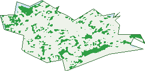
Green: 10 m cells where trees dominate, satellite 2021. Blue: water. The line is the suburb boundary.
| Canopy share, 1 m canopy height map, 2020 | 14.1% |
|---|---|
| Surveyed canopy, Greater Sydney aerial survey, 2019 | 20.5% |
| Land with trees, 10 m satellite map, 2021 | 12.2% |
Demographics
Unemployment 3.9% · Labour-force participation 68.7%
Population by age in Balmain
| 0-4 | 636 |
|---|---|
| 5-14 | 1,173 |
| 15-19 | 421 |
| 20-24 | 395 |
| 25-34 | 1,297 |
| 35-44 | 1,784 |
| 45-54 | 1,709 |
| 55-64 | 1,342 |
| 65-74 | 1,047 |
| 75-84 | 522 |
| 85+ | 136 |
Dwelling types in Balmain
| House | 974 |
|---|---|
| Townhouse | 1,785 |
| Apartment | 1,684 |
| Other | 24 |
Households by weekly income in Balmain
| <$650 | 520 |
|---|---|
| $650-1,499 | 661 |
| $1,500-2,999 | 938 |
| $3,000+ | 2,155 |
Top ancestries in Balmain
| English | 4,266 |
|---|---|
| Australian | 2,889 |
| Irish | 1,908 |
| Scottish | 1,359 |
| Other | 1,260 |
| Italian | 494 |
Housing tenure in Balmain
| Owned | 1,276 |
|---|---|
| Mortgage | 1,258 |
| Rented | 1,853 |
| Other | 48 |
Cars per household in Balmain
| 0 | 666 |
|---|---|
| 1 | 2,426 |
| 2 | 1,113 |
| 3 | 172 |
| 4+ | 60 |
Commute to work in Balmain
| Car | 1,077 |
|---|---|
| Train | 5 |
| Bus | 128 |
| Tram/ferry | 28 |
| Walked | 215 |
| Bicycle | 54 |
| Home | 3,479 |
Top countries of birth in Balmain
| England | 949 |
|---|---|
| New Zealand | 292 |
| United States | 174 |
| Ireland | 140 |
| China | 130 |
| Scotland | 107 |
Languages used at home in Balmain
| Mandarin | 159 |
|---|---|
| Italian | 123 |
| Spanish | 104 |
| French | 82 |
| Greek | 80 |
| Cantonese | 55 |
Birds & Wildlife Nearby
197,937 bird observations recorded near Balmain — most often seen:
- Rainbow Lorikeet (20,932)
- Noisy Miner (17,911)
- Australian White Ibis (16,685)
- Silver Gull (13,148)
- Rock Dove (12,056)
- Australian Magpie (11,746)
- Pied Currawong (8,684)
- Welcome Swallow (8,464)
- Sulphur-crested Cockatoo (8,072)
- Common Myna (7,612)
- Laughing Kookaburra (6,436)
- Australian Raven (6,037)
- Masked Lapwing (5,678)
Show all 30 birds recorded near Balmain
- Dusky Moorhen (5,291)
- Little Black Cormorant (4,964)
- Australian Brush-turkey (4,669)
- Magpie-lark (4,383)
- Grey Butcherbird (4,218)
- Australian Wood Duck (3,978)
- Pacific Black Duck (3,925)
- Crested Pigeon (3,476)
- Little Pied Cormorant (3,178)
- White-faced Heron (2,732)
- Australasian Figbird (2,311)
- Channel-billed Cuckoo (2,215)
- Little Corella (1,983)
- Southern Noisy Miner (1,893)
- Pied Cormorant (1,771)
- Spotted Turtle-dove (1,767)
- Eastern Rainbow Lorikeet (1,722)
Sightings reported by observers, not a survey, so the counts show what people record rather than what lives here. Source: Atlas of Living Australia.
Nearby Suburbs
The closest suburbs to Balmain:
- Birchgrove (0.7 km)
- Rozelle (1 km)
- Balmain East (1.3 km)
- Pyrmont (1.9 km)
- Barangaroo (2.2 km)
- Woolwich (2.2 km)
- Lilyfield (2.3 km)
- Millers Point (2.3 km)
Embed this suburb
Add this free Balmain stat card to your own site — just copy the code:
Preview:
Cite this page
Quoting these figures? Copy the credit line:
Keep an eye on Balmain
One email when this data meaningfully changes — new census figures, prices, rankings. No spam, unsubscribe anytime.
Streets
- Addison Street (4)
- Adolphus Street (72)
- Alexander Street (11)
- Ann Street (30)
- Arthur Street (76)
- Barr Street (52)
- Batty Street (25)
- Bayville Street (8)
- Beattie Street (301)
- Birchgrove Road (100)
- Blake Street (1)
- Booth Street (81)
- Bradford Street (44)
- Bridge Street (15)
- Broderick Street (15)
- Buchanan Street (187)
- Cameron Street (10)
- Campbell Lane (1)
- Campbell Street (109)
- Cardwell Street (21)
- Carieville Street (9)
- Caroline Lane (2)
- Caroline Street (80)
- Carrington Street (21)
- Charles Street (6)
- Church Street (45)
- Claremont Street (15)
- Clay Street (20)
- Clayton Street (57)
- Colgate Avenue (154)
- College Street (126)
- Cooper Street (15)
- Creek Street (8)
- Curtis Road (133)
- Darling Street (941)
- Darvall Street (18)
- Datchett Street (27)
- Davidson Street (16)
- Dick Street (39)
- Donnelly Street (35)
- Duncan Street (3)
- Eaton Street (3)
- Elliott Street (462)
- Ennis Street (28)
- Evans Street (76)
- Ewell Street (28)
- Ewenton Lane (1)
- Ewenton Street (58)
- Fawcett Street (11)
- Fitzroy Avenue (25)
- Ford Street (8)
- Foy Street (195)
- George Street (45)
- Gladstone Street (33)
- Glassop Street (157)
- Gow Lane (1)
- Gow Street (67)
- Grafton Lane (1)
- Grafton Street (53)
- Hampton Street (21)
- Harris Street (46)
- Henry Street (13)
- High Street (42)
- Hoffmans Lane (16)
- Hyam Street (127)
- Isabella Street (17)
- Jacques Street (27)
- James Street (9)
- Jane Street (27)
- Jubilee Place (22)
- King Lane (2)
- King Street (78)
- Laggan Avenue (61)
- Lawson Street (59)
- Little Arthur Street (1)
- Little Beattie Street (1)
- Little Darling Street (26)
- Little Llewellyn Street (6)
- Little Street (5)
- Little Theodore Street (5)
- Llewellyn Street (67)
- Lockhart Avenue (35)
- Longview Street (20)
- Macquarie Terrace (59)
- Marshall Street (2)
- Mcdonald Street (6)
- Montague Street (78)
- Mort Street (118)
- Mullens Street (182)
- North Street (35)
- Palmer Street (272)
- Pashley Street (37)
- Phillip Street (39)
- Phoebe Street (16)
- Punch Street (7)
- Queens Place (13)
- Reynolds Avenue (15)
- Reynolds Street (261)
- Roseberry Street (56)
- Rosebery Place (109)
- Rosser Street (30)
- Rowntree Street (87)
- Rumsay Lane (1)
- Schultz Street (6)
- Short Street (39)
- Smith Street (45)
- Sorrie Street (11)
- St Andrew Street (19)
- St John Street (5)
- Stephen Street (43)
- Stewart Place (4)
- Stewart Street (17)
- Sutton Lane (2)
- Sutton Street (13)
- Terry Street (31)
- Thames Street (117)
- Theodore Street (42)
- Tilba Avenue (9)
- Tobruk Avenue (8)
- Trivetts Lane (14)
- Trouton Street (68)
- Turner Street (29)
- Valley Street (25)
- Vincent Street (33)
- Waite Avenue (16)
- Wallace Street (6)
- Walter Street (1)
- Waterview Street (69)
- Watson Lane (22)
- Wells Street (21)
- White Street (17)
- Wisbeach Street (44)
- Wortley Street (39)
- Young Street (10)