Pyrmont NSW 2009
10,505 addresses · 43 streets
Sydney Electorate › Sydney LGA › Pyrmont · 1 km from Sydney
📦 Thinking of moving here? Read the Pyrmont moving guide

Living Here
A dense harbourside inner-Sydney suburb of converted wharves and new apartments, Pyrmont is professional and one of the country's most densely populated areas. Households average 2.1 people and the median age is 37. Median household income is $2,422 a week, with rent around $580.
Pyrmont is a suburb of New South Wales, home to about 12,658 people, with a median age of 37. The typical household earns around $2,422 a week, with median rent near $580 a week. Most homes are apartments. About 36% of households own their home and 62% rent. Most workers work from home. Common community backgrounds include English, Chinese, Australian. On the ABS socio-economic scale it sits in decile 10 of 10 nationally — a relatively advantaged area.
Over time — Census 2001 → 2021
Dashed line: district figures for the Pyrmont - Ultimo statistical area (SA2), the smallest area the ABS published before 2011. Solid line: Pyrmont itself.
Getting Around & Local Services
105 schools
2 carpenters
Getting around. Train station: Wynyard, 1.2 km east · Metro station: Barangaroo, 1.4 km north-east · Light rail stop: Bank Street, 200 m south-west · Bus interchange: Mount St (501), 50 m west · Ferry wharf: Casino Wharf, 400 m north-east · Airport: Rose Bay Seaplane Base, 6.4 km east.
Socio-economic Standing
Deciles from 1 (lowest) to 10 (highest), against all Australian suburbs. The overall figure weighs advantage and disadvantage together; economic resources counts income and housing, and education & jobs counts qualifications and occupation. They often differ. Source: ABS SEIFA 2021.
Tree cover
🌳 Tree canopy: 8.4% share of land under canopy · satellite map, 2020
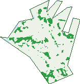
Green: 10 m cells where trees dominate, satellite 2021. Blue: water. The line is the suburb boundary.
| Canopy share, 1 m canopy height map, 2020 | 8.4% |
|---|---|
| Land with trees, 10 m satellite map, 2021 | 9.5% |
Demographics
Unemployment 5.4% · Labour-force participation 67.1%
Population by age in Pyrmont
| 0-4 | 612 |
|---|---|
| 5-14 | 684 |
| 15-19 | 296 |
| 20-24 | 708 |
| 25-34 | 3,197 |
| 35-44 | 2,708 |
| 45-54 | 1,489 |
| 55-64 | 1,325 |
| 65-74 | 1,087 |
| 75-84 | 447 |
| 85+ | 98 |
Dwelling types in Pyrmont
| House | 0 |
|---|---|
| Townhouse | 317 |
| Apartment | 5,233 |
| Other | 4 |
Households by weekly income in Pyrmont
| <$650 | 554 |
|---|---|
| $650-1,499 | 916 |
| $1,500-2,999 | 1,631 |
| $3,000+ | 2,231 |
Top ancestries in Pyrmont
| Other | 2,830 |
|---|---|
| English | 2,590 |
| Chinese | 2,250 |
| Australian | 1,761 |
| Ancestry NS | 1,033 |
| Irish | 1,020 |
Housing tenure in Pyrmont
| Owned | 989 |
|---|---|
| Mortgage | 1,004 |
| Rented | 3,443 |
| Other | 80 |
Cars per household in Pyrmont
| 0 | 1,580 |
|---|---|
| 1 | 2,940 |
| 2 | 844 |
| 3 | 97 |
| 4+ | 26 |
Commute to work in Pyrmont
| Car | 1,029 |
|---|---|
| Train | 84 |
| Bus | 171 |
| Tram/ferry | 59 |
| Walked | 784 |
| Bicycle | 104 |
| Home | 3,776 |
Top countries of birth in Pyrmont
| China | 781 |
|---|---|
| England | 529 |
| India | 510 |
| Thailand | 318 |
| New Zealand | 283 |
| Indonesia | 263 |
Languages used at home in Pyrmont
| Mandarin | 872 |
|---|---|
| Cantonese | 545 |
| Spanish | 424 |
| Thai | 325 |
| Indonesian | 208 |
| Portuguese | 205 |
Birds & Wildlife Nearby
349,820 bird observations recorded near Pyrmont — most often seen:
- Rainbow Lorikeet (27,384)
- Noisy Miner (25,092)
- Australian White Ibis (24,213)
- Rock Dove (18,353)
- Silver Gull (16,877)
- Australian Magpie (15,833)
- Welcome Swallow (14,663)
- Pied Currawong (14,143)
- Dusky Moorhen (13,219)
- Common Myna (13,098)
- Sulphur-crested Cockatoo (12,210)
- Pacific Black Duck (11,976)
- Australian Raven (11,304)
Show all 30 birds recorded near Pyrmont
- Magpie-lark (10,694)
- Little Black Cormorant (10,478)
- Laughing Kookaburra (9,817)
- Masked Lapwing (9,613)
- Crested Pigeon (9,132)
- Australasian Purple Swamphen (8,173)
- Eurasian Coot (8,020)
- Little Pied Cormorant (7,992)
- Grey Butcherbird (7,715)
- Black Swan (7,140)
- Australian Wood Duck (7,114)
- Willie Wagtail (6,618)
- Pied Cormorant (6,022)
- Little Corella (6,004)
- Australasian Darter (5,783)
- White-faced Heron (5,729)
- Hardhead (5,411)
Sightings reported by observers, not a survey, so the counts show what people record rather than what lives here. Source: Atlas of Living Australia.
Nearby Suburbs
The closest suburbs to Pyrmont:
- Barangaroo (1 km)
- Ultimo (1.2 km)
- Glebe (1.2 km)
- Sydney (1.2 km)
- Haymarket (1.4 km)
- Millers Point (1.4 km)
- Balmain East (1.4 km)
- The Rocks (1.6 km)
Embed this suburb
Add this free Pyrmont stat card to your own site — just copy the code:
Preview:
Cite this page
Quoting these figures? Copy the credit line:
Keep an eye on Pyrmont
One email when this data meaningfully changes — new census figures, prices, rankings. No spam, unsubscribe anytime.
Streets
- Ada Place (17)
- Allen Street (126)
- Bank Street (39)
- Bayview Street (1)
- Bowman Street (498)
- Bulwara Road (247)
- Bunn Street (302)
- Cadigal Avenue (200)
- Cross Street (26)
- Darling Island Road (174)
- Distillery Drive (364)
- Edward Street (10)
- Experiment Street (59)
- Fig Street (42)
- Gipps Street (7)
- Harris Street (1,694)
- Harvey Street (79)
- Harwood Street (98)
- Herbert Street (1)
- John Street (135)
- Jones Bay Road (117)
- Jones Street (317)
- Little Mount Street (35)
- Mill Street (8)
- Miller Street (643)
- Mount Street (83)
- Mount Street Walk (79)
- Murray Street (342)
- Paternoster Row (37)
- Pirrama Road (757)
- Point Street (552)
- Pyrmont Bridge Road (177)
- Pyrmont Street (1,348)
- Quarry Master Drive (174)
- Refinery Drive (488)
- Saunders Street (418)
- Scott Street (24)
- Tambua Street (128)
- Union Street (95)
- Wattle Crescent (455)
- Wattle Street (61)
- Western Distributor (3)
- Wharf Crescent (45)