Kingston ACT 2604
6,853 addresses · 33 streets
Canberra Electorate › Unincorporated ACT LGA › Kingston · 4 km from Canberra
📦 Thinking of moving here? Read the Kingston moving guide

Living Here
Kingston is a suburb of Australian Capital Territory, home to about 6,579 people, with a median age of 35. The typical household earns around $2,469 a week, with median rent near $510 a week. Most homes are apartments. About 48% of households own their home and 51% rent. Most workers drive to work. Common community backgrounds include English, Australian, Irish. On the ABS socio-economic scale it sits in decile 10 of 10 nationally — a relatively advantaged area.
Over time — Census 2001 → 2021
Dashed line: district figures for the Kingston - Barton statistical area (SA2), the smallest area the ABS published before 2011. Solid line: Kingston itself.
Getting Around & Local Services
6 supermarkets
14 Catholic churches
5 optometrists
9 playgrounds
- Sandalwood Street Central Community Playground
- Telopea District Park
- Light Street Neighbourhood Playground
- Flinders Way Neighbourhood Playground
- Throsby Lane Neighbourhood Playground
- Anembo Street Neighbourhood Playground (West)
- Wells Gardens Neighbourhood Playground
- Boundless
- Stokes Street Neighbourhood Playground
1 dog park
2 plumbers
Getting around. Train station: Canberra, 600 m south-east · Light rail stop: Alinga Street, 4.4 km north · Bus interchange: City Bus Station, 4.3 km north · Airport: Canberra Airport, 4.6 km east.
Socio-economic Standing
Deciles from 1 (lowest) to 10 (highest), against all Australian suburbs. The overall figure weighs advantage and disadvantage together; economic resources counts income and housing, and education & jobs counts qualifications and occupation. They often differ. Source: ABS SEIFA 2021.
Tree cover
🌳 Tree canopy: 5% share of land under canopy · satellite map, 2020
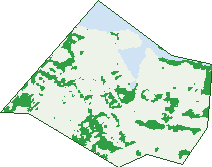
Green: 10 m cells where trees dominate, satellite 2021. Blue: water. The line is the suburb boundary.
| Canopy share, 1 m canopy height map, 2020 | 5.0% |
|---|---|
| Land with trees, 10 m satellite map, 2021 | 19.4% |
Demographics
Unemployment 2.4% · Labour-force participation 75.3%
Population by age in Kingston
| 0-4 | 236 |
|---|---|
| 5-14 | 327 |
| 15-19 | 146 |
| 20-24 | 462 |
| 25-34 | 1,996 |
| 35-44 | 1,202 |
| 45-54 | 744 |
| 55-64 | 685 |
| 65-74 | 516 |
| 75-84 | 217 |
| 85+ | 42 |
Dwelling types in Kingston
| House | 99 |
|---|---|
| Townhouse | 212 |
| Apartment | 2,980 |
| Other | 0 |
Households by weekly income in Kingston
| <$650 | 136 |
|---|---|
| $650-1,499 | 371 |
| $1,500-2,999 | 1,291 |
| $3,000+ | 1,364 |
Top ancestries in Kingston
| English | 2,335 |
|---|---|
| Australian | 1,800 |
| Irish | 997 |
| Other | 896 |
| Scottish | 835 |
| Ancestry NS | 658 |
Housing tenure in Kingston
| Owned | 575 |
|---|---|
| Mortgage | 1,008 |
| Rented | 1,673 |
| Other | 26 |
Cars per household in Kingston
| 0 | 208 |
|---|---|
| 1 | 2,060 |
| 2 | 874 |
| 3 | 107 |
| 4+ | 31 |
Commute to work in Kingston
| Car | 2,336 |
|---|---|
| Train | 4 |
| Bus | 273 |
| Tram/ferry | 0 |
| Walked | 500 |
| Bicycle | 199 |
| Home | 580 |
Top countries of birth in Kingston
| England | 245 |
|---|---|
| China | 98 |
| New Zealand | 97 |
| India | 92 |
| United States | 74 |
| South Africa | 54 |
Languages used at home in Kingston
| Mandarin | 131 |
|---|---|
| French | 95 |
| Spanish | 63 |
| Cantonese | 61 |
| Italian | 46 |
| Arabic | 45 |
Birds & Wildlife Nearby
807,410 bird observations recorded near Kingston — most often seen:
- Australian Magpie (53,834)
- Magpie-lark (49,035)
- Pied Currawong (40,441)
- Sulphur-crested Cockatoo (38,017)
- Red Wattlebird (37,400)
- Galah (36,135)
- Australian Raven (34,038)
- Crimson Rosella (33,677)
- Superb Fairy-wren (33,258)
- Crested Pigeon (29,732)
- Common Starling (28,073)
- Pacific Black Duck (26,546)
- Noisy Miner (25,848)
Show all 30 birds recorded near Kingston
- Silvereye (24,802)
- Eurasian Coot (24,538)
- Australian Wood Duck (22,518)
- Eurasian Blackbird (21,513)
- Eastern Rosella (21,266)
- Grey Fantail (21,089)
- Australasian Purple Swamphen (20,399)
- Australian King-parrot (20,201)
- Willie Wagtail (20,108)
- Dusky Moorhen (19,524)
- Rock Dove (18,536)
- Red-rumped Parrot (18,377)
- Black Swan (18,163)
- Gang-gang Cockatoo (18,095)
- Welcome Swallow (18,046)
- Common Myna (17,645)
- Grey Teal (16,556)
Sightings reported by observers, not a survey, so the counts show what people record rather than what lives here. Source: Atlas of Living Australia.
Nearby Suburbs
The closest suburbs to Kingston:
- Barton (1.1 km)
- Griffith (1.1 km)
- Forrest (1.6 km)
- Russell (1.9 km)
- Capital Hill (2.2 km)
- Narrabundah (2.2 km)
- Parkes (2.8 km)
- Campbell (2.9 km)
Embed this suburb
Add this free Kingston stat card to your own site — just copy the code:
Preview:
Cite this page
Quoting these figures? Copy the credit line:
Keep an eye on Kingston
One email when this data meaningfully changes — new census figures, prices, rankings. No spam, unsubscribe anytime.
Streets
- Blueberry Street (26)
- Burke Crescent (61)
- Charles Francis Lane (2)
- Charles Roach Lane (12)
- Cooinda Court (6)
- Cunningham Street (87)
- Currie Crescent (64)
- Dawes Street (284)
- Eastlake Parade (926)
- Eurabbie Street (5)
- Eyre Street (1,054)
- Geijera Place (5)
- Giles Street (454)
- Gosse Street (102)
- Honeysett View (180)
- Howitt Street (421)
- Jardine Street (488)
- Kennedy Street (247)
- Kerridge Street (373)
- Leichhardt Street (214)
- Marri Street (10)
- Mundaring Drive (1)
- Parbery Street (157)
- Percy Douglas Lane (2)
- Printers Way (176)
- Sandalwood Street (2)
- Spinifex Street (15)
- Telopea Park (18)
- Tench Street (178)
- The Causeway (337)
- Trevillian Quay (538)
- Waygoose Street (19)
- Wentworth Avenue (389)