Forrest ACT 2603
1,730 addresses · 31 streets
Canberra Electorate › Unincorporated ACT LGA › Forrest · 4 km from Canberra
📦 Thinking of moving here? Read the Forrest moving guide

Living Here
Forrest is a suburb of Australian Capital Territory, home to about 1,827 people, with a median age of 47. The typical household earns around $3,363 a week, with median rent near $570 a week. Most homes are apartments. About 67% of households own their home and 31% rent. Most workers drive to work. Common community backgrounds include English, Australian, Irish. On the ABS socio-economic scale it sits in decile 10 of 10 nationally — a relatively advantaged area.
Over time — Census 2001 → 2021
Dashed line: district figures for the Forrest statistical area (SA2), the smallest area the ABS published before 2011. Solid line: Forrest itself.
Getting Around & Local Services
16 Catholic churches
- St Christopher’s Cathedral
- St Benedicts
- Saint Peter and Paul Catholic Church
- The Catholic Diocese of the Australian Defence Force
- School Chapel
- ANZAC Memorial Chapel of St Paul (RMC Chapel)
- St Patrick's Roman Catholic Church
- St Augustine's Catholic Church
- Saint Josephs Catholic
- Mary Help of Christians Parish
5 optometrists
10 childcare & kindergartens
- Forrest Early Childhood Centre
- Only About Children
- Papilio Early Learning Yarralumla
- Possum Magic Day Care Centre
- Urban Education Early Learning Centre
- French-Australian Preschool
- Narrabundah Early Childhood School
- Aeon Academy
- Marlee Early Education and Care Centre
- One Tree Defence Childcare Unit Russell Hill
1 dog park
2 plumbers
Getting around. Train station: Canberra, 2 km east · Light rail stop: Alinga Street, 4.3 km north · Bus interchange: Canberra Civic Coach Stop, 4.2 km north · Airport: Canberra Airport, 6.2 km east.
Socio-economic Standing
Deciles from 1 (lowest) to 10 (highest), against all Australian suburbs. The overall figure weighs advantage and disadvantage together; economic resources counts income and housing, and education & jobs counts qualifications and occupation. They often differ. Source: ABS SEIFA 2021.
Tree cover
🌳 Tree canopy: 9.5% share of land under canopy · satellite map, 2020
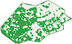
Green: 10 m cells where trees dominate, satellite 2021. Blue: water. The line is the suburb boundary.
| Canopy share, 1 m canopy height map, 2020 | 9.5% |
|---|---|
| Land with trees, 10 m satellite map, 2021 | 57.3% |
Demographics
Unemployment 2.8% · Labour-force participation 68.1%
Population by age in Forrest
| 0-4 | 44 |
|---|---|
| 5-14 | 163 |
| 15-19 | 93 |
| 20-24 | 95 |
| 25-34 | 277 |
| 35-44 | 187 |
| 45-54 | 282 |
| 55-64 | 270 |
| 65-74 | 239 |
| 75-84 | 149 |
| 85+ | 36 |
Dwelling types in Forrest
| House | 287 |
|---|---|
| Townhouse | 133 |
| Apartment | 366 |
| Other | 0 |
Households by weekly income in Forrest
| <$650 | 46 |
|---|---|
| $650-1,499 | 84 |
| $1,500-2,999 | 218 |
| $3,000+ | 413 |
Top ancestries in Forrest
| English | 625 |
|---|---|
| Australian | 534 |
| Irish | 278 |
| Other | 258 |
| Scottish | 254 |
| Italian | 105 |
Housing tenure in Forrest
| Owned | 296 |
|---|---|
| Mortgage | 230 |
| Rented | 240 |
| Other | 20 |
Cars per household in Forrest
| 0 | 32 |
|---|---|
| 1 | 320 |
| 2 | 296 |
| 3 | 78 |
| 4+ | 56 |
Commute to work in Forrest
| Car | 551 |
|---|---|
| Train | 0 |
| Bus | 33 |
| Tram/ferry | 0 |
| Walked | 143 |
| Bicycle | 29 |
| Home | 192 |
Top countries of birth in Forrest
| England | 55 |
|---|---|
| India | 38 |
| China | 30 |
| New Zealand | 29 |
| United States | 23 |
| Sri Lanka | 20 |
Languages used at home in Forrest
| Mandarin | 45 |
|---|---|
| Italian | 45 |
| Greek | 38 |
| French | 24 |
| Hindi | 20 |
| Sinhalese | 19 |
Birds & Wildlife Nearby
946,779 bird observations recorded near Forrest — most often seen:
- Australian Magpie (65,201)
- Magpie-lark (59,149)
- Pied Currawong (50,889)
- Superb Fairy-wren (47,803)
- Red Wattlebird (46,277)
- Sulphur-crested Cockatoo (45,813)
- Galah (41,376)
- Crimson Rosella (40,810)
- Australian Raven (39,837)
- Crested Pigeon (32,928)
- Silvereye (30,642)
- Pacific Black Duck (30,223)
- Common Starling (29,945)
Show all 30 birds recorded near Forrest
- Noisy Miner (27,977)
- Eurasian Coot (27,412)
- Australian Wood Duck (27,303)
- Eurasian Blackbird (26,350)
- Australian King-parrot (25,970)
- Grey Fantail (23,402)
- Australasian Purple Swamphen (23,133)
- Eastern Rosella (22,645)
- Rock Dove (21,874)
- Dusky Moorhen (21,348)
- Willie Wagtail (21,001)
- White-browed Scrubwren (20,959)
- Common Myna (20,054)
- Welcome Swallow (19,603)
- Gang-gang Cockatoo (19,304)
- Red-rumped Parrot (18,945)
- Black Swan (18,606)
Sightings reported by observers, not a survey, so the counts show what people record rather than what lives here. Source: Atlas of Living Australia.
Nearby Suburbs
The closest suburbs to Forrest:
- Barton (1 km)
- Griffith (1.2 km)
- Capital Hill (1.3 km)
- Kingston (1.6 km)
- Deakin (2.3 km)
- Yarralumla (2.6 km)
- Red Hill (2.6 km)
- Narrabundah (2.7 km)
Embed this suburb
Add this free Forrest stat card to your own site — just copy the code:
Preview:
Cite this page
Quoting these figures? Copy the credit line:
Keep an eye on Forrest
One email when this data meaningfully changes — new census figures, prices, rankings. No spam, unsubscribe anytime.
Streets
- Arthur Circle (91)
- Barkly Crescent (13)
- Baudin Street (13)
- Bougainville Street (43)
- Canberra Avenue (187)
- Dampier Crescent (15)
- Davey Crescent (2)
- Dominion Circuit (257)
- Ducane Street (45)
- Empire Circuit (219)
- Fitzroy Street (61)
- Franklin Street (108)
- Furneaux Street (13)
- Hobart Avenue (16)
- Manuka Circle (10)
- Melbourne Avenue (19)
- Moresby Street (1)
- Mugga Way (16)
- Nares Crescent (5)
- National Circuit (171)
- New South Wales Crescent (77)
- Ord Street (8)
- Rous Crescent (4)
- Somers Crescent (28)
- Sorell Street (4)
- State Circle (174)
- Sydney Avenue (26)
- Talbot Street (20)
- Tasmania Circle (48)
- Tennyson Crescent (23)
- Wilmot Crescent (13)