Woodlands WA 6018
2,139 addresses · 61 streets
Curtin Electorate › Stirling LGA › Woodlands · 8 km from Perth
📦 Thinking of moving here? Read the Woodlands moving guide

Living Here
Woodlands is a suburb of Western Australia, home to about 4,551 people, with a median age of 44. The typical household earns around $2,098 a week, with median rent near $420 a week. Most homes are houses. About 79% of households own their home and 18% rent. Most workers drive to work. Common community backgrounds include English, Australian, Irish. On the ABS socio-economic scale it sits in decile 10 of 10 nationally — a relatively advantaged area.
Over time — Census 2001 → 2021
Dashed line: district figures for the Wembley Downs - Churchlands - Woodlands statistical area (SA2), the smallest area the ABS published before 2011. Solid line: Woodlands itself.
Getting Around & Local Services
45 schools
1 beach
33 hospitals
- Osborne Park Hospital
- Hawthorn House
- St John of God Subiaco Eye Hospital
- Perth Day Surgery Centre
- Saint John of God Hospital Subiaco
- Subiaco Private Hospital
- West Leederville Private Hospital
- King Edward Memorial Hospital
- Abbotsford Private Hospital
- City Lower West Older Adult Mental Health Service (Selby OAMH)
3 bakeries
2 butchers
2 hairdressers
2 plumbers
Getting around. Train station: Stirling, 1.8 km north-east · Metro station: Perth Underground, 7.9 km south-east · Bus interchange: Mirrabooka Bus Station, 7.4 km north-east · Airport: Perth Airport, 16.5 km east.
Socio-economic Standing
Deciles from 1 (lowest) to 10 (highest), against all Australian suburbs. The overall figure weighs advantage and disadvantage together; economic resources counts income and housing, and education & jobs counts qualifications and occupation. They often differ. Source: ABS SEIFA 2021.
Tree cover
🌳 Tree canopy: 9.7% share of land under canopy · satellite map, 2020
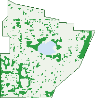
Green: 10 m cells where trees dominate, satellite 2021. Blue: water. The line is the suburb boundary.
| Canopy share, 1 m canopy height map, 2020 | 9.7% |
|---|---|
| Land with trees, 10 m satellite map, 2021 | 12.7% |
Demographics
Unemployment 3.8% · Labour-force participation 60%
Population by age in Woodlands
| 0-4 | 177 |
|---|---|
| 5-14 | 674 |
| 15-19 | 341 |
| 20-24 | 233 |
| 25-34 | 347 |
| 35-44 | 545 |
| 45-54 | 684 |
| 55-64 | 456 |
| 65-74 | 394 |
| 75-84 | 448 |
| 85+ | 241 |
Dwelling types in Woodlands
| House | 1,150 |
|---|---|
| Townhouse | 334 |
| Apartment | 176 |
| Other | 0 |
Households by weekly income in Woodlands
| <$650 | 258 |
|---|---|
| $650-1,499 | 367 |
| $1,500-2,999 | 350 |
| $3,000+ | 586 |
Top ancestries in Woodlands
| English | 1,776 |
|---|---|
| Australian | 1,452 |
| Other | 518 |
| Irish | 489 |
| Scottish | 481 |
| Italian | 324 |
Housing tenure in Woodlands
| Owned | 772 |
|---|---|
| Mortgage | 532 |
| Rented | 292 |
| Other | 45 |
Cars per household in Woodlands
| 0 | 92 |
|---|---|
| 1 | 566 |
| 2 | 658 |
| 3 | 206 |
| 4+ | 110 |
Commute to work in Woodlands
| Car | 1,382 |
|---|---|
| Train | 26 |
| Bus | 47 |
| Tram/ferry | 0 |
| Walked | 40 |
| Bicycle | 34 |
| Home | 248 |
Top countries of birth in Woodlands
| England | 319 |
|---|---|
| South Africa | 98 |
| Malaysia | 96 |
| India | 77 |
| China | 74 |
| New Zealand | 71 |
Languages used at home in Woodlands
| Mandarin | 124 |
|---|---|
| Italian | 78 |
| Cantonese | 64 |
| Japanese | 42 |
| Spanish | 32 |
| French | 30 |
Birds & Wildlife Nearby
217,491 bird observations recorded near Woodlands — most often seen:
- Pacific Black Duck (10,862)
- Eurasian Coot (10,438)
- Willie Wagtail (10,200)
- Australian White Ibis (9,998)
- Dusky Moorhen (9,680)
- Australian Raven (9,481)
- Red Wattlebird (8,821)
- Grey Teal (8,633)
- Australasian Grebe (8,615)
- Rainbow Lorikeet (8,578)
- Black Swan (8,414)
- Australasian Purple Swamphen (8,269)
- Australian Shelduck (7,396)
Show all 30 birds recorded near Woodlands
- Singing Honeyeater (7,368)
- Little Pied Cormorant (6,324)
- Magpie-lark (6,301)
- Great Egret (6,283)
- Laughing Turtle-dove (6,029)
- Australian Wood Duck (5,996)
- Brown Honeyeater (5,817)
- Great Crested Grebe (5,676)
- Welcome Swallow (5,656)
- Little Corella (5,639)
- Little Black Cormorant (5,515)
- Australian Reed Warbler (5,465)
- Australian Magpie (5,445)
- Australian Pelican (5,265)
- Musk Duck (5,170)
- Blue-billed Duck (5,115)
- Australasian Shoveler (5,042)
Sightings reported by observers, not a survey, so the counts show what people record rather than what lives here. Source: Atlas of Living Australia.
Nearby Suburbs
The closest suburbs to Woodlands:
- Innaloo (1.7 km)
- Doubleview (1.8 km)
- Churchlands (2 km)
- Wembley Downs (2 km)
- Herdsman (2.1 km)
- Osborne Park (2.7 km)
- Glendalough (2.9 km)
- Scarborough (2.9 km)
Embed this suburb
Add this free Woodlands stat card to your own site — just copy the code:
Preview:
Cite this page
Quoting these figures? Copy the credit line:
Keep an eye on Woodlands
One email when this data meaningfully changes — new census figures, prices, rankings. No spam, unsubscribe anytime.
Streets
- Angelico Street (13)
- Athel Road (35)
- Bentwood Avenue (54)
- Birchwood Avenue (69)
- Blackbutt Road (33)
- Bowra Avenue (15)
- Burgay Court (1)
- Carrick Street (53)
- Castle Road (73)
- Cedar Place (19)
- Cherry Road (23)
- Clematis Road (22)
- Coronation Street (19)
- Davis Court (5)
- Elmwood Avenue (38)
- Ewen Street (120)
- Ferrer Place (12)
- Fry Place (14)
- Granich Gardens (17)
- Grant Street (40)
- Hakea Road (23)
- Hale Road (38)
- Hazel Avenue (49)
- Howie Street (17)
- Humbert Street (5)
- Huntriss Road (96)
- Imelda Street (5)
- Islip Place (10)
- Jackadder Way (21)
- Jarret Street (24)
- Laurel Road (14)
- Lefroy Street (14)
- Liege Street (343)
- Lombardy Street (47)
- Loton Street (15)
- Mahlberg Avenue (57)
- Marlock Place (13)
- Marlock Road (11)
- Muriel Avenue (36)
- Oakwood Avenue (25)
- Pearson Street (64)
- Pinewood Avenue (18)
- Rosewood Avenue (83)
- Rowan Place (22)
- Sabina Street (19)
- Sadoc Street (7)
- Sandalwood Avenue (37)
- Scarborough Beach Road (31)
- Scott Court (6)
- Sonnet Close (32)
- Suso Street (11)
- Sweeting Street (13)
- Talbot Road (37)
- Talbot Way (7)
- Tamarisk Way (19)
- Teakwood Avenue (36)
- Valencia Avenue (2)
- Williamstown Road (6)
- Willow Road (43)
- Willow Way (4)
- Woodlands Street (104)