Westminster WA 6061
4,096 addresses · 69 streets
Cowan Electorate › Stirling LGA › Westminster · 10 km from Perth
📦 Thinking of moving here? Read the Westminster moving guide
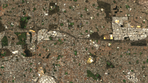
Living Here
Westminster is a suburb of Western Australia, home to about 7,042 people, with a median age of 34. The typical household earns around $1,404 a week, with median rent near $330 a week. Most homes are houses. About 54% of households own their home and 45% rent. Most workers drive to work. Common community backgrounds include English, Australian, Indian. On the ABS socio-economic scale it sits in decile 2 of 10 nationally — a more disadvantaged area.
Over time — Census 2001 → 2021
Dashed line: district figures for the Nollamara - Westminster statistical area (SA2), the smallest area the ABS published before 2011. Solid line: Westminster itself.
Getting Around & Local Services
2 pharmacies
2 doctors & medical clinics
9 service stations
1 playground
1 bakery
2 hairdressers
2 plumbers
1 carpenter
Getting around. Train station: Stirling, 4.4 km south-west · Bus interchange: Mirrabooka Bus Station, 1.9 km east · Airport: Perth Airport, 14.4 km south-east.
Socio-economic Standing
Deciles from 1 (lowest) to 10 (highest), against all Australian suburbs. The overall figure weighs advantage and disadvantage together; economic resources counts income and housing, and education & jobs counts qualifications and occupation. They often differ. Source: ABS SEIFA 2021.
Tree cover
🌳 Tree canopy: 7% share of land under canopy · satellite map, 2020
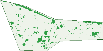
Green: 10 m cells where trees dominate, satellite 2021. Blue: water. The line is the suburb boundary.
| Canopy share, 1 m canopy height map, 2020 | 7.0% |
|---|---|
| Land with trees, 10 m satellite map, 2021 | 7.0% |
Demographics
Unemployment 6.9% · Labour-force participation 64.6%
Population by age in Westminster
| 0-4 | 581 |
|---|---|
| 5-14 | 720 |
| 15-19 | 275 |
| 20-24 | 461 |
| 25-34 | 1,547 |
| 35-44 | 1,239 |
| 45-54 | 722 |
| 55-64 | 637 |
| 65-74 | 448 |
| 75-84 | 308 |
| 85+ | 101 |
Dwelling types in Westminster
| House | 1,783 |
|---|---|
| Townhouse | 1,012 |
| Apartment | 39 |
| Other | 0 |
Households by weekly income in Westminster
| <$650 | 515 |
|---|---|
| $650-1,499 | 907 |
| $1,500-2,999 | 890 |
| $3,000+ | 324 |
Top ancestries in Westminster
| Other | 2,059 |
|---|---|
| English | 1,391 |
| Australian | 1,156 |
| Indian | 564 |
| Ancestry NS | 551 |
| Italian | 472 |
Housing tenure in Westminster
| Owned | 528 |
|---|---|
| Mortgage | 987 |
| Rented | 1,254 |
| Other | 26 |
Cars per household in Westminster
| 0 | 200 |
|---|---|
| 1 | 1,214 |
| 2 | 1,042 |
| 3 | 236 |
| 4+ | 95 |
Commute to work in Westminster
| Car | 2,490 |
|---|---|
| Train | 25 |
| Bus | 180 |
| Tram/ferry | 0 |
| Walked | 32 |
| Bicycle | 10 |
| Home | 163 |
Top countries of birth in Westminster
| India | 632 |
|---|---|
| Philippines | 188 |
| Vietnam | 179 |
| England | 176 |
| New Zealand | 138 |
| North Macedonia | 120 |
Languages used at home in Westminster
| Punjabi | 262 |
|---|---|
| Vietnamese | 249 |
| Arabic | 202 |
| Gujarati | 191 |
| Macedonian | 189 |
| Italian | 161 |
Birds & Wildlife Nearby
41,534 bird observations recorded near Westminster — most often seen:
- Australian Raven (2,194)
- Red Wattlebird (2,191)
- Laughing Turtle-dove (2,163)
- Rainbow Lorikeet (2,109)
- Willie Wagtail (2,080)
- Australian White Ibis (1,896)
- Singing Honeyeater (1,873)
- Pacific Black Duck (1,684)
- South-western Australian Magpie (1,611)
- Brown Honeyeater (1,595)
- Eurasian Coot (1,581)
- New Holland Honeyeater (1,400)
- Australian Magpie (1,343)
Show all 30 birds recorded near Westminster
- Australasian Grebe (1,303)
- Western Red Wattlebird (1,265)
- Galah (1,222)
- Eastern Rainbow Lorikeet (1,184)
- South-western Singing Honeyeater (1,171)
- Western Australian Raven (1,110)
- Magpie-lark (1,097)
- Black Swan (1,076)
- Little Corella (1,050)
- Spotted Turtle-dove (1,015)
- Dusky Moorhen (965)
- Western Brown Honeyeater (940)
- Southern Willie Wagtail (933)
- Grey Teal (916)
- Australasian Purple Swamphen (888)
- Australian Wood Duck (884)
- Australian Shelduck (795)
Sightings reported by observers, not a survey, so the counts show what people record rather than what lives here. Source: Atlas of Living Australia.
Nearby Suburbs
The closest suburbs to Westminster:
- Nollamara (1.4 km)
- Balga (1.4 km)
- Balcatta (1.7 km)
- Mirrabooka (2.7 km)
- Girrawheen (2.9 km)
- Stirling (3.2 km)
- Hamersley (3.2 km)
- Tuart Hill (3.3 km)
Embed this suburb
Add this free Westminster stat card to your own site — just copy the code:
Preview:
Cite this page
Quoting these figures? Copy the credit line:
Keep an eye on Westminster
One email when this data meaningfully changes — new census figures, prices, rankings. No spam, unsubscribe anytime.
Streets
- Amberley Way (89)
- Amelia Street (53)
- Arkana Road (263)
- Balcombe Street (68)
- Balcombe Way (60)
- Beeley Street (18)
- Belka Court (4)
- Bilinga Road (55)
- Blackdoune Way (46)
- Canara Road (84)
- Changton Way (75)
- Chipala Road (89)
- Deering Street (36)
- Durham Way (47)
- Eartham Place (15)
- Edale Way (72)
- Esperanto Way (116)
- Findon Crescent (93)
- Gibb Crescent (64)
- Gretham Road (91)
- Halland Way (101)
- Harkins Street (30)
- Harris Way (68)
- Hartfield Way (80)
- Jessel Court (11)
- Kurda Place (32)
- Kurda Road (61)
- Lindfield Street (73)
- Lodesworth Road (120)
- Majella Road (52)
- Marloo Road (93)
- Martin Court (27)
- Mayfield Street (42)
- Medbury Road (86)
- Melba Place (15)
- Mirrabooka Avenue (35)
- Nutley Street (11)
- Offham Way (91)
- Patchem Way (47)
- Peppering Way (85)
- Poynings Street (37)
- Princess Road (77)
- Pycombe Way (68)
- Rail Street (18)
- Ravenswood Drive (136)
- Reddy Court (10)
- Reeves Court (11)
- Ringmer Way (70)
- Rotherfield Road (59)
- Rowe Court (4)
- Salmar Way (88)
- Selhan Place (8)
- Shelbred Way (105)
- Shipley Place (56)
- Steyning Way (52)
- Storrington Crescent (65)
- Stroughton Road (86)
- Sutherland Street (10)
- Tontave Road (31)
- Ungaroo Road (72)
- Victoria Road (20)
- Vincent Avenue (34)
- Wanneroo Road (131)
- Wardong Road (49)
- Wolya Place (30)
- Wolya Way (66)
- Worthing Street (49)
- Wychcross Street (41)
- Yorna Road (15)