Wagin WA 6315
1,424 addresses · 102 streets
O'Connor Electorate › Wagin LGA › Wagin · 205 km from Perth
📦 Thinking of moving here? Read the Wagin moving guide

Living Here
Wagin is a suburb of Western Australia, home to about 1,448 people, with a median age of 51. The typical household earns around $1,073 a week, with median rent near $195 a week. Most homes are houses. About 75% of households own their home and 25% rent. Most workers drive to work. Common community backgrounds include English, Australian, Ancestry NS. On the ABS socio-economic scale it sits in decile 2 of 10 nationally — a more disadvantaged area.
Over time — Census 2001 → 2021
Dashed line: district figures for the Wagin statistical area (SA2), the smallest area the ABS published before 2011. Solid line: Wagin itself.
Getting Around & Local Services
1 school
2 cafés & restaurants
2 supermarkets
1 Catholic church
1 pharmacy
1 medical clinic
1 hospital
1 childcare centre
1 library
1 post office
2 service stations
1 gym
1 golf club
1 bakery
1 butcher
1 hardware store
1 hairdresser
Getting around. Airport: Narrogin Airport, 48.6 km north-west.
Socio-economic Standing
Deciles from 1 (lowest) to 10 (highest), against all Australian suburbs. The overall figure weighs advantage and disadvantage together; economic resources counts income and housing, and education & jobs counts qualifications and occupation. They often differ. Source: ABS SEIFA 2021.
Tree cover
🌳 Tree canopy: 4.2% share of land under canopy · satellite map, 2020
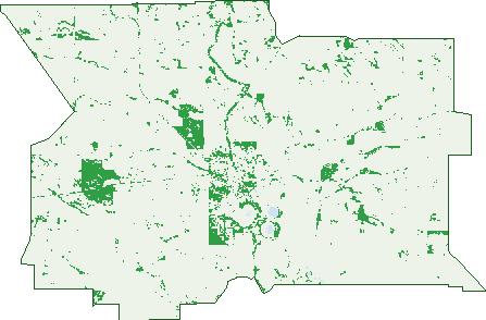
Green: 10 m cells where trees dominate, satellite 2021. Blue: water. The line is the suburb boundary.
| Canopy share, 1 m canopy height map, 2020 | 4.2% |
|---|---|
| Land with trees, 10 m satellite map, 2021 | 7.7% |
Demographics
Unemployment 5.8% · Labour-force participation 48.9%
Population by age in Wagin
| 0-4 | 71 |
|---|---|
| 5-14 | 144 |
| 15-19 | 58 |
| 20-24 | 57 |
| 25-34 | 142 |
| 35-44 | 138 |
| 45-54 | 154 |
| 55-64 | 248 |
| 65-74 | 237 |
| 75-84 | 143 |
| 85+ | 47 |
Dwelling types in Wagin
| House | 542 |
|---|---|
| Townhouse | 38 |
| Apartment | 0 |
| Other | 4 |
Households by weekly income in Wagin
| <$650 | 147 |
|---|---|
| $650-1,499 | 180 |
| $1,500-2,999 | 153 |
| $3,000+ | 47 |
Top ancestries in Wagin
| English | 642 |
|---|---|
| Australian | 579 |
| Ancestry NS | 154 |
| Scottish | 124 |
| Irish | 115 |
| Other | 51 |
Housing tenure in Wagin
| Owned | 252 |
|---|---|
| Mortgage | 172 |
| Rented | 140 |
| Other | 5 |
Cars per household in Wagin
| 0 | 40 |
|---|---|
| 1 | 199 |
| 2 | 208 |
| 3 | 81 |
| 4+ | 44 |
Commute to work in Wagin
| Car | 394 |
|---|---|
| Train | 0 |
| Bus | 10 |
| Tram/ferry | 0 |
| Walked | 29 |
| Bicycle | 0 |
| Home | 31 |
Top countries of birth in Wagin
| England | 91 |
|---|---|
| New Zealand | 61 |
| Philippines | 33 |
| Scotland | 8 |
| Malaysia | 6 |
| Netherlands | 6 |
Languages used at home in Wagin
| Filipino | 17 |
|---|---|
| Tagalog | 15 |
| Australian Indigenous | 6 |
| Vietnamese | 4 |
| Russian | 3 |
| Thai | 3 |
Birds & Wildlife Nearby
2,771 bird observations recorded near Wagin — most often seen:
- Australian Shelduck (187)
- Grey Teal (182)
- Australian Raven (166)
- Red Wattlebird (151)
- Pacific Black Duck (140)
- Welcome Swallow (132)
- Australian Ringneck (126)
- Silver Gull (123)
- White-cheeked Honeyeater (115)
- Brown Honeyeater (111)
- Pink-eared Duck (100)
- Weebill (90)
- Common Bronzewing (88)
Show all 30 birds recorded near Wagin
- Australian Wood Duck (79)
- Australian Magpie (75)
- Western Australian Raven (74)
- Eurasian Coot (70)
- Tree Martin (70)
- Willie Wagtail (69)
- Twenty-eight Parrot (68)
- White-faced Heron (67)
- South-western Australian Magpie (65)
- Crested Pigeon (57)
- Western Brown Honeyeater (57)
- Singing Honeyeater (56)
- Black Swan (54)
- Laughing Turtle-dove (52)
- Silvereye (52)
- Western Red Wattlebird (51)
- Hardhead (44)
Sightings reported by observers, not a survey, so the counts show what people record rather than what lives here. Source: Atlas of Living Australia.
Nearby Suburbs
The closest suburbs to Wagin:
- Lime Lake (9.9 km)
- Gundaring (14.5 km)
- Piesseville (15.7 km)
- Minding (16.3 km)
- Jaloran (17.4 km)
- Wedgecarrup (18.1 km)
- Collanilling (18.7 km)
- Boyerine (21.5 km)
Embed this suburb
Add this free Wagin stat card to your own site — just copy the code:
Preview:
Cite this page
Quoting these figures? Copy the credit line:
Keep an eye on Wagin
One email when this data meaningfully changes — new census figures, prices, rankings. No spam, unsubscribe anytime.
Streets
- Airfield Road (4)
- Andrews Street (1)
- Arnott Street (12)
- Arthur Road (15)
- Badgarning Road (1)
- Ballagin Road (23)
- Ballagin Street (38)
- Bank Place (2)
- Beaufort Road (1)
- Beaufort Street (1)
- Becker Road (2)
- Bedford Lane (5)
- Blythe Lane (1)
- Bockaring Road (1)
- Boddington Street (14)
- Bolts Road (5)
- Bullock Hills Road (4)
- Campbell Street (2)
- Charles Street (7)
- Chester Road (1)
- Costelloe Street (11)
- Cowcher Place (13)
- Dongolocking Road (1)
- Etelowie Street (23)
- Forrest Street (6)
- George Street (10)
- Giles Street (4)
- Gordon Street (7)
- Great Southern Highway (6)
- Hugh Street (5)
- Hunt Street (12)
- Ingram Lane (4)
- Jaloran Road (3)
- Jenz Road (1)
- Johnson Road (1)
- Johnston Street (55)
- Khedive Street (74)
- Kitchener Street (10)
- Leake Way (1)
- Lefroy Street (4)
- Leonora Street (12)
- Lloyd Street (13)
- Lukin Street (4)
- Marks Court (6)
- Miller Street (2)
- Mitchell Street (7)
- Moore Street (13)
- Nalder Street (15)
- Nenke Street (15)
- Omdurman Street (59)
- Pederick Drive (13)
- Puntaping Road (2)
- Randall Street (8)
- Ranford Street (10)
- Rifle North Street (20)
- Rifle Street (19)
- Sawle Street (21)
- Scaddan Street (17)
- Scott Street (3)
- Sirdar Street (32)
- Stewart Road (3)
- Strickland Street (9)
- Stubbs Street (33)
- Tarbet Street (10)
- Tasman Street (6)
- Tavistock Street (36)
- Tennyson Street (2)
- Theta Street (6)
- Thornton Street (17)
- Throssell Lane (1)
- Throssell Street (2)
- Tillellan Road (3)
- Traverse Street (24)
- Trench Street (31)
- Trent Street (22)
- Trenton Street (17)
- Trimdon Street (13)
- Tudhoe Street (98)
- Tudor Street (55)
- Ultra Street (2)
- Umbra Street (14)
- Una Street (12)
- Unicorn Street (29)
- Union Street (1)
- Unit Street (13)
- Upland Street (64)
- Urban Street (32)
- Vale Street (5)
- Venice Street (7)
- Ventnor Street (44)
- Vera Street (8)
- Verdant Street (2)
- Vernal Street (23)
- Vernon Street (11)
- Vesper Street (8)
- Victor Street (8)
- Vine Street (7)
- Wagin-dumbleyung Road (6)
- Ware Street (27)
- Warnocks Road (1)
- Warwick Street (28)
- Wendell Street (2)