Spearwood WA 6163
6,189 addresses · 168 streets
Fremantle Electorate › Cockburn LGA › Spearwood · 18 km from Perth
📦 Thinking of moving here? Read the Spearwood moving guide

Living Here
Spearwood is a suburb of Western Australia, home to about 10,944 people, with a median age of 41. The typical household earns around $1,448 a week, with median rent near $350 a week. Most homes are houses. About 70% of households own their home and 29% rent. Most workers drive to work. Common community backgrounds include English, Australian, Italian. On the ABS socio-economic scale it sits in decile 5 of 10 nationally — a mid-range area.
Over time — Census 2001 → 2021
Dashed line: district figures for the Spearwood statistical area (SA2), the smallest area the ABS published before 2011. Solid line: Spearwood itself.
Getting Around & Local Services
1 pharmacy
1 dentist
1 physiotherapist
2 optometrists
1 childcare centre
2 post offices
1 playground
1 bakery
1 butcher
1 beauty salon
1 plumber
Getting around. Train station: Fremantle, 6.9 km north-west · Bus interchange: Fremantle Station, 6.9 km north-west · Ferry wharf: Kayak Launch, 6 km north-west · Airport: Jandakot Airport, 8.9 km east.
Socio-economic Standing
Deciles from 1 (lowest) to 10 (highest), against all Australian suburbs. The overall figure weighs advantage and disadvantage together; economic resources counts income and housing, and education & jobs counts qualifications and occupation. They often differ. Source: ABS SEIFA 2021.
Tree cover
🌳 Tree canopy: 14% share of land under canopy · satellite map, 2020
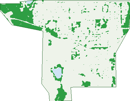
Green: 10 m cells where trees dominate, satellite 2021. Blue: water. The line is the suburb boundary.
| Canopy share, 1 m canopy height map, 2020 | 14.0% |
|---|---|
| Land with trees, 10 m satellite map, 2021 | 16.4% |
Demographics
Unemployment 5.2% · Labour-force participation 60.6%
Population by age in Spearwood
| 0-4 | 620 |
|---|---|
| 5-14 | 1,054 |
| 15-19 | 504 |
| 20-24 | 715 |
| 25-34 | 1,569 |
| 35-44 | 1,407 |
| 45-54 | 1,422 |
| 55-64 | 1,336 |
| 65-74 | 1,185 |
| 75-84 | 783 |
| 85+ | 349 |
Dwelling types in Spearwood
| House | 3,288 |
|---|---|
| Townhouse | 936 |
| Apartment | 243 |
| Other | 0 |
Households by weekly income in Spearwood
| <$650 | 831 |
|---|---|
| $650-1,499 | 1,284 |
| $1,500-2,999 | 1,248 |
| $3,000+ | 730 |
Top ancestries in Spearwood
| English | 3,553 |
|---|---|
| Australian | 2,852 |
| Italian | 1,625 |
| Other | 1,512 |
| Irish | 886 |
| Scottish | 859 |
Housing tenure in Spearwood
| Owned | 1,568 |
|---|---|
| Mortgage | 1,502 |
| Rented | 1,288 |
| Other | 47 |
Cars per household in Spearwood
| 0 | 253 |
|---|---|
| 1 | 1,737 |
| 2 | 1,626 |
| 3 | 497 |
| 4+ | 290 |
Commute to work in Spearwood
| Car | 3,915 |
|---|---|
| Train | 46 |
| Bus | 121 |
| Tram/ferry | 0 |
| Walked | 52 |
| Bicycle | 20 |
| Home | 297 |
Top countries of birth in Spearwood
| England | 616 |
|---|---|
| Italy | 428 |
| Philippines | 379 |
| Croatia | 351 |
| New Zealand | 285 |
| South Africa | 105 |
Languages used at home in Spearwood
| Italian | 572 |
|---|---|
| Croatian | 462 |
| Portuguese | 274 |
| Tagalog | 180 |
| Serbian | 164 |
| Filipino | 136 |
Birds & Wildlife Nearby
108,188 bird observations recorded near Spearwood — most often seen:
- Australian Raven (5,405)
- Willie Wagtail (5,227)
- Pacific Black Duck (5,108)
- Australian White Ibis (4,868)
- Red Wattlebird (4,559)
- Australian Shelduck (4,437)
- Grey Teal (4,327)
- Black Swan (4,175)
- Silver Gull (4,149)
- Rainbow Lorikeet (4,115)
- Eurasian Coot (4,083)
- South-western Australian Magpie (3,880)
- Welcome Swallow (3,664)
Show all 30 birds recorded near Spearwood
- Galah (3,558)
- Laughing Turtle-dove (3,558)
- Australian Magpie (3,546)
- Australian Pelican (3,508)
- White-faced Heron (3,462)
- Australasian Purple Swamphen (3,132)
- Splendid Fairy-wren (2,901)
- Western Australian Raven (2,863)
- Australasian Shoveler (2,827)
- Musk Duck (2,772)
- Western Red Wattlebird (2,730)
- Australasian Grebe (2,671)
- Singing Honeyeater (2,627)
- Magpie-lark (2,570)
- New Holland Honeyeater (2,556)
- Silvereye (2,466)
- Great Egret (2,444)
Sightings reported by observers, not a survey, so the counts show what people record rather than what lives here. Source: Atlas of Living Australia.
Nearby Suburbs
The closest suburbs to Spearwood:
- Coogee (1.8 km)
- Hamilton Hill (2.4 km)
- Lake Coogee (2.5 km)
- North Coogee (2.6 km)
- Munster (2.7 km)
- Yangebup (3.1 km)
- Bibra Lake (3.3 km)
- Coolbellup (3.4 km)
Embed this suburb
Add this free Spearwood stat card to your own site — just copy the code:
Preview:
Cite this page
Quoting these figures? Copy the credit line:
Keep an eye on Spearwood
One email when this data meaningfully changes — new census figures, prices, rankings. No spam, unsubscribe anytime.
Streets
- Adela Place (49)
- Alfred Street (12)
- Angus Avenue (57)
- Anise Court (24)
- Aspic Crescent (25)
- Auden Court (6)
- Aumerle Way (30)
- Azelia Road (13)
- Balfern Way (24)
- Bardolph Road (38)
- Barrett Street (28)
- Barrington Street (37)
- Bilcich Gardens (21)
- Birbeck Way (33)
- Blato Place (13)
- Blunt Place (5)
- Bohemia Street (16)
- Bolingbroke Street (56)
- Bosnich Way (23)
- Boswell Place (12)
- Bramston Street (26)
- Brenzi Court (12)
- Buchan Close (15)
- Buktenica Court (7)
- Bullfinch Street (52)
- Bunyan Close (15)
- Buran Way (20)
- Burgundy Crescent (22)
- Bushy Road (64)
- Cale Place (6)
- Campion Close (9)
- Cedar Court (7)
- Chaucer Close (16)
- Chesterton Street (27)
- Cobine Street (29)
- Coleville Crescent (8)
- Conrad Court (6)
- Cottage Parade (26)
- Crystalline Road (40)
- Daffodil Court (26)
- Dane Place (4)
- Denham Street (34)
- Ditullio Close (21)
- Donne Court (11)
- Doolette Street (155)
- Dubove Road (36)
- Edeline Street (193)
- Emba Place (7)
- Entrance Road (44)
- Etherington Avenue (36)
- Exton Place (9)
- Fallow Crescent (72)
- Falstaff Crescent (74)
- Favazzo Place (17)
- Ferris Way (33)
- Fig Close (5)
- Fitzwater Way (42)
- Fontina Road (9)
- Fox Street (34)
- Freeth Road (44)
- Galian Way (50)
- Galsworthy Place (21)
- Garden Road (67)
- Gaunt Road (41)
- Gerald Street (115)
- Gerovich Way (17)
- Glendower Way (76)
- Goffe Street (33)
- Goldsmith Road (93)
- Gorham Way (41)
- Gower Street (3)
- Graham Street (25)
- Grljusich Place (16)
- Gurney Road (55)
- Hamilton Road (215)
- Hereford Place (14)
- Hillberg Rise (11)
- Hobley Way (24)
- Hopkins Way (43)
- Hotspur Road (33)
- Hudson Court (8)
- Huljich Place (5)
- Huxley Place (23)
- Ibsen Court (5)
- Interim Road (14)
- Ionesco Street (39)
- Josip Gaspar Close (16)
- Karbuni Parade (35)
- Keats Place (14)
- Kennon Court (10)
- Kent Street (108)
- Kingsley Close (19)
- Lancaster Street (37)
- Leaside Way (97)
- Leavis Place (9)
- Leo Place (7)
- Leonard Way (53)
- Lilly Court (20)
- Lintott Way (37)
- Macmorris Way (25)
- Makarska Way (17)
- Malcolm Street (24)
- March Street (66)
- Marchesi Loop (27)
- Mark Place (2)
- Marvell Avenue (36)
- Mears Place (15)
- Mell Road (203)
- Melun Street (43)
- Milos Loop (29)
- Mollica Court (8)
- Nadilo Drive (52)
- Newton Street (77)
- Nineham Avenue (39)
- Norland Way (95)
- Nym Place (4)
- October Road (10)
- Olinda Court (16)
- Oreb Place (6)
- Orleans Street (18)
- Orsulich Loop (35)
- Pallett Avenue (59)
- Parrott Way (4)
- Pear Place (6)
- Pecorino Lane (13)
- Pennlake Drive (50)
- Pepys Court (10)
- Phoenix Road (181)
- Pistol Street (24)
- Plum Place (5)
- Poins Place (5)
- Pomfret Road (34)
- Potter Court (16)
- Prada Way (8)
- Reserve Road (47)
- Rigby Avenue (47)
- Rockingham Road (487)
- Rosa Place (13)
- Ross Court (22)
- Rover Lane (11)
- Salway Place (13)
- Scales Way (76)
- Scroop Way (47)
- Separovich Way (27)
- Shallow Street (25)
- Sitwell Close (14)
- Skeahan Street (68)
- Sparrow Way (27)
- Spearwood Avenue (166)
- Steinbeck Place (20)
- Stevenson Way (27)
- Stook Court (23)
- Sunset Court (10)
- Sussex Street (71)
- Teto Place (2)
- Thackeray Street (21)
- Todd Street (18)
- Travers Street (14)
- Trellis Place (20)
- Troode Street (4)
- Ukich Crescent (36)
- Vernon Place (27)
- Vis Lane (14)
- Watercress Gardens (24)
- Wollemi Street (17)
- Yakas Chase (19)
- Zlinya Circle (72)
- Zukova Close (14)