Silver Sands WA 6210
935 addresses · 34 streets
Canning Electorate › Mandurah LGA › Silver Sands · 63 km from Perth
📦 Thinking of moving here? Read the Silver Sands moving guide

Living Here
Silver Sands is a suburb of Western Australia, home to about 1,451 people, with a median age of 47. The typical household earns around $1,399 a week, with median rent near $340 a week. Most homes are houses. About 71% of households own their home and 28% rent. Most workers drive to work. Common community backgrounds include English, Australian, Scottish. On the ABS socio-economic scale it sits in decile 5 of 10 nationally — a mid-range area.
Over time — Census 2001 → 2021
Dashed line: district figures for the Mandurah statistical area (SA2), the smallest area the ABS published before 2011. Solid line: Silver Sands itself.
Getting Around & Local Services
17 schools
- North Mandurah Primary School
- John Tonkin College (Tindale Campus)
- Assumption Catholic Primary School
- Frederick Irwin Anglican School - Meadow Springs Campus
- Meadow Springs Education Support Centre
- Mandurah Primary School
- Greenfields Primary School
- Oakwood Primary School
- Foundation Christian College
- Dudley Park Primary School
4 supermarkets
1 pharmacy
2 dentists
2 hospitals
1 post office
3 gyms & sports centres
1 playground
1 bakery
3 mechanics
1 electrician
1 plumber
Getting around. Train station: Mandurah, 2.3 km south-east · Ferry wharf: Mandurah Dolphin Cruises, 2.7 km south-west · Airport: Jandakot Airport, 48 km north.
Socio-economic Standing
Deciles from 1 (lowest) to 10 (highest), against all Australian suburbs. The overall figure weighs advantage and disadvantage together; economic resources counts income and housing, and education & jobs counts qualifications and occupation. They often differ. Source: ABS SEIFA 2021.
Tree cover
🌳 Tree canopy: 9.6% share of land under canopy · satellite map, 2020
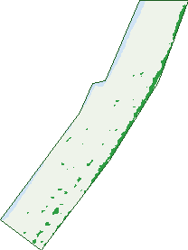
Green: 10 m cells where trees dominate, satellite 2021. Blue: water. The line is the suburb boundary.
| Canopy share, 1 m canopy height map, 2020 | 9.6% |
|---|---|
| Land with trees, 10 m satellite map, 2021 | 5.4% |
Demographics
Unemployment 6.1% · Labour-force participation 53.9%
Population by age in Silver Sands
| 0-4 | 86 |
|---|---|
| 5-14 | 151 |
| 15-19 | 77 |
| 20-24 | 63 |
| 25-34 | 140 |
| 35-44 | 157 |
| 45-54 | 193 |
| 55-64 | 221 |
| 65-74 | 220 |
| 75-84 | 108 |
| 85+ | 36 |
Dwelling types in Silver Sands
| House | 533 |
|---|---|
| Townhouse | 20 |
| Apartment | 0 |
| Other | 0 |
Households by weekly income in Silver Sands
| <$650 | 117 |
|---|---|
| $650-1,499 | 147 |
| $1,500-2,999 | 136 |
| $3,000+ | 92 |
Top ancestries in Silver Sands
| English | 743 |
|---|---|
| Australian | 493 |
| Scottish | 193 |
| Irish | 187 |
| Ancestry NS | 77 |
| Other | 69 |
Housing tenure in Silver Sands
| Owned | 216 |
|---|---|
| Mortgage | 171 |
| Rented | 151 |
| Other | 10 |
Cars per household in Silver Sands
| 0 | 17 |
|---|---|
| 1 | 195 |
| 2 | 223 |
| 3 | 68 |
| 4+ | 42 |
Commute to work in Silver Sands
| Car | 393 |
|---|---|
| Train | 17 |
| Bus | 13 |
| Tram/ferry | 0 |
| Walked | 14 |
| Bicycle | 0 |
| Home | 51 |
Top countries of birth in Silver Sands
| England | 162 |
|---|---|
| New Zealand | 49 |
| Scotland | 22 |
| South Africa | 16 |
| Ireland | 14 |
| Philippines | 10 |
Languages used at home in Silver Sands
| Spanish | 9 |
|---|---|
| Mandarin | 8 |
| Afrikaans | 5 |
| Croatian | 5 |
| Italian | 5 |
| Filipino | 4 |
Birds & Wildlife Nearby
20,353 bird observations recorded near Silver Sands — most often seen:
- Australian Pelican (1,084)
- Australian White Ibis (1,016)
- Australian Raven (1,004)
- Little Pied Cormorant (1,003)
- Red Wattlebird (993)
- Silver Gull (958)
- Galah (938)
- Pacific Black Duck (919)
- Little Black Cormorant (780)
- Great Egret (763)
- Australasian Darter (741)
- White-faced Heron (615)
- Twenty-eight Parrot (607)
Show all 30 birds recorded near Silver Sands
- Australian Ringneck (590)
- Grey Teal (589)
- Welcome Swallow (587)
- South-western Australian Magpie (584)
- Whistling Kite (582)
- Willie Wagtail (578)
- Australian Wood Duck (526)
- Australian Magpie (525)
- Yellow-billed Spoonbill (514)
- Common Bronzewing (510)
- Pied Cormorant (508)
- Black Swan (504)
- Rock Dove (501)
- Little Corella (496)
- Magpie-lark (477)
- Little Egret (433)
- Red-capped Parrot (428)
Sightings reported by observers, not a survey, so the counts show what people record rather than what lives here. Source: Atlas of Living Australia.
Nearby Suburbs
The closest suburbs to Silver Sands:
- Mandurah (2.2 km)
- Meadow Springs (2.2 km)
- San Remo (2.2 km)
- Greenfields (3.1 km)
- Parklands (3.9 km)
- Dudley Park (4.3 km)
- Madora Bay (4.6 km)
- Coodanup (4.8 km)
Embed this suburb
Add this free Silver Sands stat card to your own site — just copy the code:
Preview:
Cite this page
Quoting these figures? Copy the credit line:
Keep an eye on Silver Sands
One email when this data meaningfully changes — new census figures, prices, rankings. No spam, unsubscribe anytime.
Streets
- Adonis Road (19)
- Asteria Court (15)
- Barwell Street (17)
- Breaker Close (21)
- Clytie Road (32)
- Collier Street (35)
- Cook Street (4)
- Creon Way (29)
- Driftwood Road (16)
- Hamilton Way (32)
- Haven Court (11)
- Henson Street (8)
- Hickman Road (159)
- Keats Street (6)
- Kelly Street (8)
- Mandurah Terrace (2)
- Mardan Court (12)
- Maritime Road (8)
- Nestor Way (38)
- Orion Road (26)
- Ormsby Terrace (94)
- Perseus Road (88)
- Petina Court (7)
- Priam Road (17)
- Quamby Court (23)
- Riana Place (5)
- Rocklea Place (23)
- Seawind Drive (45)
- Sefton Court (12)
- Shaw Street (1)
- Sievewright Street (42)
- Tallas Road (36)
- Wade Street (3)
- Watersun Drive (41)