Perth WA 6000
18,826 addresses · 130 streets
Perth Electorate › Perth LGA › Perth · 0 km from Perth
📦 Thinking of moving here? Read the Perth moving guide

Living Here
Western Australia's capital-city centre, Perth is a riverside CBD with a growing apartment population. Small households of 1.8 people and a median age of 33 reflect city workers and students. Median household income is $1,960 a week, with rent around $400.
Perth is a suburb of Western Australia, home to about 13,670 people, with a median age of 33. The typical household earns around $1,960 a week, with median rent near $400 a week. Most homes are apartments. About 33% of households own their home and 66% rent. Most workers drive to work. Common community backgrounds include English, Australian, Chinese. On the ABS socio-economic scale it sits in decile 10 of 10 nationally — a relatively advantaged area.
Over time — Census 2001 → 2021
Dashed line: district figures for the Perth City statistical area (SA2), the smallest area the ABS published before 2011. Solid line: Perth itself.
Getting Around & Local Services
5 childcare & kindergartens
Getting around. Train station: Perth, 50 m south · Metro station: Perth Underground, 250 m west · Bus interchange: Perth Busport Zone A, 350 m west · Ferry wharf: Wild West Charters, 850 m south-west · Airport: Perth Airport, 9.6 km east.
Socio-economic Standing
Deciles from 1 (lowest) to 10 (highest), against all Australian suburbs. The overall figure weighs advantage and disadvantage together; economic resources counts income and housing, and education & jobs counts qualifications and occupation. They often differ. Source: ABS SEIFA 2021.
Tree cover
🌳 Tree canopy: 6.5% share of land under canopy · satellite map, 2020
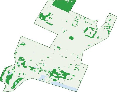
Green: 10 m cells where trees dominate, satellite 2021. Blue: water. The line is the suburb boundary.
| Canopy share, 1 m canopy height map, 2020 | 6.5% |
|---|---|
| Land with trees, 10 m satellite map, 2021 | 11.0% |
Demographics
Unemployment 5.4% · Labour-force participation 69.4%
Population by age in Perth
| 0-4 | 440 |
|---|---|
| 5-14 | 501 |
| 15-19 | 308 |
| 20-24 | 1,631 |
| 25-34 | 4,774 |
| 35-44 | 2,569 |
| 45-54 | 1,352 |
| 55-64 | 1,093 |
| 65-74 | 660 |
| 75-84 | 255 |
| 85+ | 77 |
Dwelling types in Perth
| House | 518 |
|---|---|
| Townhouse | 668 |
| Apartment | 4,796 |
| Other | 4 |
Households by weekly income in Perth
| <$650 | 799 |
|---|---|
| $650-1,499 | 1,271 |
| $1,500-2,999 | 2,022 |
| $3,000+ | 1,501 |
Top ancestries in Perth
| English | 3,335 |
|---|---|
| Other | 2,675 |
| Australian | 2,102 |
| Chinese | 1,820 |
| Ancestry NS | 1,686 |
| Irish | 1,157 |
Housing tenure in Perth
| Owned | 730 |
|---|---|
| Mortgage | 1,220 |
| Rented | 3,935 |
| Other | 49 |
Cars per household in Perth
| 0 | 1,383 |
|---|---|
| 1 | 3,348 |
| 2 | 988 |
| 3 | 146 |
| 4+ | 51 |
Commute to work in Perth
| Car | 2,967 |
|---|---|
| Train | 238 |
| Bus | 920 |
| Tram/ferry | 3 |
| Walked | 1,763 |
| Bicycle | 185 |
| Home | 673 |
Top countries of birth in Perth
| China | 784 |
|---|---|
| England | 704 |
| India | 546 |
| Malaysia | 331 |
| New Zealand | 320 |
| Vietnam | 257 |
Languages used at home in Perth
| Mandarin | 1,053 |
|---|---|
| Spanish | 299 |
| Cantonese | 298 |
| Vietnamese | 292 |
| Italian | 168 |
| Korean | 160 |
Birds & Wildlife Nearby
151,114 bird observations recorded near Perth — most often seen:
- Rainbow Lorikeet (8,460)
- Red Wattlebird (8,326)
- Pacific Black Duck (8,294)
- Willie Wagtail (7,842)
- Australian Raven (7,590)
- Eurasian Coot (6,304)
- Singing Honeyeater (6,005)
- Australian Wood Duck (5,945)
- Australian White Ibis (5,822)
- Dusky Moorhen (5,778)
- Australian Magpie (5,671)
- Black Swan (5,572)
- Magpie-lark (5,471)
Show all 30 birds recorded near Perth
- Australasian Grebe (5,177)
- Laughing Turtle-dove (4,783)
- Brown Honeyeater (4,331)
- Australasian Darter (4,310)
- Little Pied Cormorant (4,242)
- Little Black Cormorant (4,107)
- Silver Gull (3,904)
- New Holland Honeyeater (3,792)
- South-western Australian Magpie (3,676)
- Australian Shelduck (3,615)
- Welcome Swallow (3,544)
- Little Corella (3,464)
- Australian Pelican (3,173)
- Australasian Purple Swamphen (3,043)
- Galah (3,013)
- Hardhead (2,989)
- Spotted Turtle-dove (2,871)
Sightings reported by observers, not a survey, so the counts show what people record rather than what lives here. Source: Atlas of Living Australia.
Nearby Suburbs
The closest suburbs to Perth:
- Northbridge (0.7 km)
- East Perth (1.4 km)
- West Perth (1.5 km)
- Highgate (1.5 km)
- Kings Park (2.6 km)
- Mount Lawley (2.6 km)
- Leederville (2.7 km)
- North Perth (2.7 km)
Embed this suburb
Add this free Perth stat card to your own site — just copy the code:
Preview:
Cite this page
Quoting these figures? Copy the credit line:
Keep an eye on Perth
One email when this data meaningfully changes — new census figures, prices, rankings. No spam, unsubscribe anytime.
Streets
- Aberdeen Street (238)
- Adelaide Terrace (781)
- Amy Street (6)
- Astone Lane (2)
- Baker Avenue (10)
- Barrack Square (316)
- Barrack Street (257)
- Beaufort Street (525)
- Braid Street (39)
- Brewer Street (173)
- Brisbane Place (14)
- Brisbane Street (221)
- Brisbane Terrace (25)
- Brookman Street (32)
- Bulwer Avenue (22)
- Bulwer Street (443)
- Cantle Street (15)
- Cathedral Avenue (2)
- Caversham Street (4)
- Chapman Street (22)
- Chelsea Street (2)
- Cheriton Street (70)
- Church Street (29)
- Claisebrook Road (103)
- Coolgardie Terrace (5)
- Dalmeny Street (1)
- Dangan Street (32)
- Dilhorn Lane (4)
- Earl Street (1)
- Edith Street (24)
- Edward Street (104)
- Elder Street (2)
- Fitzgerald Street (153)
- Forbes Lane (1)
- Forbes Road (14)
- Fore Street (3)
- Forrest Place (20)
- Francis Street (6)
- Geoffrey Bolton Avenue (109)
- Gladstone Street (44)
- Glendower Street (93)
- Goderich Street (203)
- Grant Street (12)
- Grasso Street (1)
- Greenway Street (21)
- Hay Street (1,968)
- Hay Street Mall (484)
- Hibernian Lane (1)
- Hill Street (36)
- His Majestys Lane (1)
- Hope Street (10)
- Howard Street (20)
- Hoy Poy Street (1)
- Ioppolo Lane (2)
- Irene Street (7)
- Irwin Street (60)
- James Street (42)
- James Street Mall (6)
- King Street (114)
- Knebworth Avenue (36)
- Lacey Street (25)
- Lake Street (187)
- Lane Street (21)
- Lincoln Street (108)
- Lindsay Street (82)
- Little Parry Street (7)
- Lord Street (288)
- Marlborough Street (27)
- Mccarthy Street (15)
- Mill Street (57)
- Milligan Street (516)
- Moir Street (27)
- Money Street (110)
- Monger Street (36)
- Moore Street (3)
- Mount Street (20)
- Mounts Bay Road (803)
- Murchison Terrace (12)
- Murray Street (1,831)
- Murray Street Mall (385)
- Museum Street (2)
- Myrtle Street (22)
- Nash Street (21)
- Newcastle Street (796)
- Ophir Walk (1)
- Orange Avenue (20)
- Palmerston Street (422)
- Parry Street (89)
- Pearl Lane (4)
- Pendal Lane (82)
- Pier Street (118)
- Pisconeri Street (25)
- Primrose Street (19)
- Queen Street (22)
- Randell Lane (4)
- Randell Place (2)
- Randell Street (37)
- Riverside Drive (2)
- Robertson Street (3)
- Robinson Avenue (112)
- Roe Street (4)
- Ruth Street (42)
- Sherwood Court (39)
- Smith Street (57)
- Somerville Street (6)
- Spring Street (60)
- St Georges Terrace (2,409)
- Stirling Street (781)
- Stuart Street (44)
- Summers Street (64)
- Telethon Avenue (3)
- Terrace Road (418)
- The Esplanade (132)
- Thorley Street (1)
- Throssell Street (11)
- Tiverton Street (1)
- Valdura Place (1)
- Victoria Avenue (276)
- Victoria Square (11)
- Vincent Street (15)
- Wade Street (23)
- Washing Lane (4)
- Weld Avenue (6)
- Wellington Street (406)
- Wellman Street (3)
- West Parade (52)
- William Street (486)
- Windsor Street (52)
- Wolf Lane (1)
- Wright Street (63)