Northam WA 6401
5,173 addresses · 195 streets
Durack Electorate › Northam LGA › Northam · 83 km from Perth
📦 Thinking of moving here? Read the Northam moving guide

Living Here
Northam is a suburb of Western Australia, home to about 6,679 people, with a median age of 42. The typical household earns around $1,246 a week, with median rent near $250 a week. Most homes are houses. About 68% of households own their home and 31% rent. Most workers drive to work. Common community backgrounds include English, Australian, Ancestry NS. On the ABS socio-economic scale it sits in decile 2 of 10 nationally — a more disadvantaged area.
Over time — Census 2001 → 2021
Dashed line: district figures for the Northam statistical area (SA2), the smallest area the ABS published before 2011. Solid line: Northam itself.
Getting Around & Local Services
2 cafés & restaurants
5 supermarkets
1 Catholic church
1 hospital
1 library
1 post office
2 service stations
3 gyms & sports centres
1 golf club
Getting around. Train station: Northam, 750 m north-east.
Socio-economic Standing
Deciles from 1 (lowest) to 10 (highest), against all Australian suburbs. The overall figure weighs advantage and disadvantage together; economic resources counts income and housing, and education & jobs counts qualifications and occupation. They often differ. Source: ABS SEIFA 2021.
Tree cover
🌳 Tree canopy: 7% share of land under canopy · satellite map, 2020
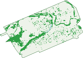
Green: 10 m cells where trees dominate, satellite 2021. Blue: water. The line is the suburb boundary.
| Canopy share, 1 m canopy height map, 2020 | 7.0% |
|---|---|
| Land with trees, 10 m satellite map, 2021 | 18.6% |
Demographics
Unemployment 6.4% · Labour-force participation 52.6%
Population by age in Northam
| 0-4 | 389 |
|---|---|
| 5-14 | 896 |
| 15-19 | 429 |
| 20-24 | 366 |
| 25-34 | 731 |
| 35-44 | 728 |
| 45-54 | 809 |
| 55-64 | 926 |
| 65-74 | 799 |
| 75-84 | 425 |
| 85+ | 182 |
Dwelling types in Northam
| House | 2,297 |
|---|---|
| Townhouse | 136 |
| Apartment | 12 |
| Other | 30 |
Households by weekly income in Northam
| <$650 | 556 |
|---|---|
| $650-1,499 | 749 |
| $1,500-2,999 | 652 |
| $3,000+ | 278 |
Top ancestries in Northam
| English | 2,648 |
|---|---|
| Australian | 2,611 |
| Ancestry NS | 718 |
| Scottish | 562 |
| Irish | 543 |
| Aboriginal | 523 |
Housing tenure in Northam
| Owned | 865 |
|---|---|
| Mortgage | 789 |
| Rented | 745 |
| Other | 27 |
Cars per household in Northam
| 0 | 177 |
|---|---|
| 1 | 891 |
| 2 | 865 |
| 3 | 340 |
| 4+ | 161 |
Commute to work in Northam
| Car | 2,016 |
|---|---|
| Train | 0 |
| Bus | 15 |
| Tram/ferry | 0 |
| Walked | 141 |
| Bicycle | 11 |
| Home | 103 |
Top countries of birth in Northam
| England | 241 |
|---|---|
| New Zealand | 154 |
| Philippines | 122 |
| India | 56 |
| Germany | 51 |
| South Africa | 40 |
Languages used at home in Northam
| Tagalog | 66 |
|---|---|
| Filipino | 38 |
| Australian Indigenous | 33 |
| Malayalam | 33 |
| Polish | 27 |
| Afrikaans | 22 |
Birds & Wildlife Nearby
40,232 bird observations recorded near Northam — most often seen:
- Twenty-eight Parrot (2,042)
- Eurasian Coot (1,952)
- Pacific Black Duck (1,932)
- Southern Willie Wagtail (1,905)
- Laughing Turtle-dove (1,895)
- Grey Teal (1,858)
- Western Australian Raven (1,857)
- South-western Singing Honeyeater (1,856)
- Western Brown Honeyeater (1,652)
- South-western Australian Magpie (1,507)
- Australian Wood Duck (1,417)
- Yellow-billed Spoonbill (1,272)
- Birds (1,269)
Show all 30 birds recorded near Northam
- Little Black Cormorant (1,266)
- Little Pied Cormorant (1,262)
- Mute Swan (1,252)
- Southern Magpie-lark (1,181)
- Rock Dove (1,175)
- Western Striated Pardalote (1,109)
- White-faced Heron (1,055)
- Australasian Grebe (1,053)
- Western Red Wattlebird (1,051)
- Western Galah (1,046)
- Mainland Tree Martin (1,005)
- Southern Rufous Whistler (987)
- Western Welcome Swallow (951)
- Southern Weebill (902)
- Giinbaywarraymal (879)
- Australian White Ibis (847)
- Western Yellow-rumped Thornbill (797)
Sightings reported by observers, not a survey, so the counts show what people record rather than what lives here. Source: Atlas of Living Australia.
Nearby Suburbs
The closest suburbs to Northam:
- Muluckine (5.5 km)
- Burlong (7.3 km)
- Irishtown (7.5 km)
- Malabaine (8.2 km)
- Spencers Brook (8.4 km)
- Muresk (8.4 km)
- Grass Valley (12 km)
- Katrine (12.2 km)
Embed this suburb
Add this free Northam stat card to your own site — just copy the code:
Preview:
Cite this page
Quoting these figures? Copy the credit line:
Keep an eye on Northam
One email when this data meaningfully changes — new census figures, prices, rankings. No spam, unsubscribe anytime.
Streets
- Abbott Street (9)
- Agett Way (23)
- Albatross Place (8)
- Albert Street (13)
- Angus Way (7)
- Arnold Street (14)
- Atkinson Street (13)
- Avon View Crescent (2)
- Barrow Street (8)
- Beamish Avenue (7)
- Beavis Place (1)
- Beswick Place (5)
- Birdie Place (10)
- Brockman Court (4)
- Broome Terrace (25)
- Bryant Street (2)
- Bunker Way (21)
- Burgoyne Street (78)
- Burlong Road (53)
- Burn Street (23)
- Burnside Avenue (63)
- Burnside Place (15)
- Byfield Street (74)
- Cecil Road (2)
- Charles Street (65)
- Chidlow Street E (178)
- Chidlow Street W (18)
- Chipping Rise (23)
- Christmass Street (22)
- Church Street (12)
- Clarke Street (24)
- Clarkson Street (28)
- Cody Street (13)
- Colebatch Street (1)
- Collins Place (6)
- Cook Street (6)
- Cox Street (14)
- Croke Avenue (102)
- Crorkan Road (1)
- Davey Court (2)
- Dempster Street (25)
- Dick Street (13)
- Doctors Drive (19)
- Dorcas Street (8)
- Dr Dunlop Grove (12)
- Dring Street (2)
- Duke Street E (168)
- Duke Street W (105)
- Dunkley Street (9)
- Dutton Street (10)
- Eagle Place (10)
- East Street (67)
- Edmondson Street (14)
- Enfield Terrace (11)
- Ensign Dale Place (1)
- Entrance Avenue (2)
- Esperance Street (13)
- Fairway Bend (45)
- Fermoy Avenue (27)
- Fernie Street (15)
- Fitzgerald Street E (259)
- Fitzgerald Street W (56)
- Foreman Street (8)
- Forrest Street (77)
- Forward Street (17)
- Frankish Road (20)
- Fraser Street (11)
- Freind Place (12)
- Gairdner Street (71)
- Garrigan Close (10)
- Gerald Terrace (27)
- Gibbings Street (35)
- Gillett Road (44)
- Golf Crescent (33)
- Goomalling Road (91)
- Gordon Place (2)
- Gordon Street (68)
- Gratte Street (2)
- Gregory Street (29)
- Grey Street (19)
- Habgood Street (13)
- Hammond Place (20)
- Hampton Street (42)
- Harper Street (4)
- Hatton Street (12)
- Hawes Street (7)
- Heal Court (2)
- Heaton Drive (16)
- Henry Street (4)
- Henty Place (9)
- Holtfreter Avenue (1)
- Hopetoun Avenue (29)
- Horley Street (15)
- Hunter Place (24)
- Hutt Street (44)
- Inkpen Street (38)
- Irishtown Road (4)
- Iwanoff Road (10)
- Jacamar Drive (20)
- James Street (23)
- Jessup Terrace (6)
- John Street (12)
- Katrine Road (52)
- Kennedy Street (47)
- Killick Street (20)
- Kings Street (6)
- Knight Street (53)
- Lance Street (4)
- Lawley Avenue (3)
- Leake Street (10)
- Leeder Place (4)
- Lewis Way (6)
- Lloyd Street (6)
- Lockyer Avenue (46)
- Loton Drive (42)
- Lunt Street (2)
- Lyon Street (34)
- Mace Street (12)
- Madden Street (13)
- Malabaine Road (1)
- Markey Street (6)
- Marshall Place (11)
- Martin Street (31)
- May Street (12)
- Mcclements Street (4)
- Mcmillan Place (2)
- Mervyn Street (8)
- Millington Street (8)
- Milner Road (6)
- Mitchell Avenue (75)
- Moore Street (14)
- Morrell Street (25)
- Mortlock Place (7)
- Mount Ommanney Road (20)
- Mudalla Road (9)
- Mudalla Way (12)
- Newcastle Road (139)
- Nicholson Street (9)
- Northey Street (8)
- Oakover Place (31)
- Old Quarry Road (1)
- Old York Road (103)
- Oliver Street (33)
- Olympic Drive (1)
- Ord Street (20)
- Ottaway Drive (10)
- Park Lane (13)
- Parker Street (8)
- Peel Terrace (48)
- Perina Place (4)
- Perina Way (47)
- Poole Street (5)
- Prince Road (2)
- Purkiss Drive (17)
- Putting Rise (24)
- Queen Street (40)
- Quelquelling Road (12)
- Railway Avenue (2)
- Riverside Outlook (17)
- Robinson Street (39)
- Rockett Street (21)
- Roediger Drive (25)
- Rushton Crescent (14)
- Selby Street (52)
- Sholl Street (10)
- Smith Grove (5)
- Solomon Close (11)
- Spencers Brook Road (8)
- Springfield Road (25)
- Stirling Street (65)
- Stoke Avenue (7)
- Strickland Avenue (25)
- Suburban Road (31)
- Tamplin Street (21)
- Tankard Street (66)
- Taylor Street (23)
- Thackrah Avenue (5)
- Thomson Street (23)
- Throssell Street (131)
- Turner Street (22)
- Uralia Terrace (10)
- Venn Street (1)
- Verlinden Road (2)
- Walarat Road (23)
- Weld Street (41)
- Wellington Street E (91)
- Wellington Street W (102)
- West Street (1)
- Withers Street (36)
- Withnell Street (17)
- Wood Drive (45)
- Woodley Farm Drive (49)
- Yalbaroo Road (31)
- Yilgarn Avenue (43)
- York Road (30)