Neridup WA 6450
90 addresses · 11 streets
O'Connor Electorate › Esperance LGA › Neridup · 617 km from Perth

Living Here
Neridup is a suburb of Western Australia, home to about 92 people, with a median age of 38. The typical household earns around $2,062 a week, with median rent near $175 a week. Most homes are houses. About 33% of households own their home and 30% rent. Most workers drive to work. Common community backgrounds include Australian, English, Scottish. On the ABS socio-economic scale it sits in decile 10 of 10 nationally — a relatively advantaged area.
Over time — Census 2001 → 2021
Dashed line: district figures for the Esperance Region statistical area (SA2), the smallest area the ABS published before 2011. Solid line: Neridup itself.
Getting Around & Local Services
Socio-economic Standing
Deciles from 1 (lowest) to 10 (highest), against all Australian suburbs. The overall figure weighs advantage and disadvantage together; economic resources counts income and housing, and education & jobs counts qualifications and occupation. They often differ. Source: ABS SEIFA 2021.
Tree cover
🌳 Tree canopy: 4.4% share of land under canopy · satellite map, 2020
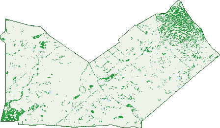
Green: 10 m cells where trees dominate, satellite 2021. Blue: water. The line is the suburb boundary.
| Canopy share, 1 m canopy height map, 2020 | 4.4% |
|---|---|
| Land with trees, 10 m satellite map, 2021 | 10.4% |
Demographics
Population by age in Neridup
| 0-4 | 7 |
|---|---|
| 5-14 | 21 |
| 15-19 | 4 |
| 20-24 | 0 |
| 25-34 | 13 |
| 35-44 | 14 |
| 45-54 | 13 |
| 55-64 | 16 |
| 65-74 | 11 |
| 75-84 | 0 |
| 85+ | 0 |
Dwelling types in Neridup
| House | 26 |
|---|---|
| Townhouse | 0 |
| Apartment | 0 |
| Other | 0 |
Households by weekly income in Neridup
| <$650 | 0 |
|---|---|
| $650-1,499 | 4 |
| $1,500-2,999 | 5 |
| $3,000+ | 11 |
Top ancestries in Neridup
| Australian | 43 |
|---|---|
| English | 38 |
| Scottish | 14 |
| German | 8 |
| Irish | 8 |
| Italian | 8 |
Housing tenure in Neridup
| Owned | 9 |
|---|---|
| Mortgage | 0 |
| Rented | 8 |
| Other | 10 |
Cars per household in Neridup
| 0 | 0 |
|---|---|
| 1 | 3 |
| 2 | 13 |
| 3 | 4 |
| 4+ | 13 |
Commute to work in Neridup
| Car | 27 |
|---|---|
| Train | 0 |
| Bus | 0 |
| Tram/ferry | 0 |
| Walked | 3 |
| Bicycle | 0 |
| Home | 16 |
Top countries of birth in Neridup
| South Africa | 4 |
|---|
Birds & Wildlife Nearby
1 bird observations recorded near Neridup — most often seen:
- Whiskered Tern (1)
Sightings reported by observers, not a survey, so the counts show what people record rather than what lives here. Source: Atlas of Living Australia.
Nearby Suburbs
The closest suburbs to Neridup:
- Wittenoom Hills (15.9 km)
- Merivale (19.2 km)
- Myrup (26 km)
- Gibson (29.9 km)
- Windabout (30.2 km)
- Bandy Creek (30.5 km)
- Castletown (31.6 km)
- Chadwick (33.3 km)
Embed this suburb
Add this free Neridup stat card to your own site — just copy the code:
Preview:
Cite this page
Quoting these figures? Copy the credit line:
Keep an eye on Neridup
One email when this data meaningfully changes — new census figures, prices, rankings. No spam, unsubscribe anytime.
Streets
- Backmans Road (15)
- Coolinup Road (4)
- Dempster Road (8)
- Fisheries Road (7)
- Green Road (10)
- Kau Rock Road (1)
- Old Smokey Road (5)
- Plowman Road (10)
- Savage Road (14)
- Scaddan Road (5)
- Wittenoom Road (11)