Midland WA 6056
6,050 addresses · 91 streets
Hasluck Electorate › Swan LGA › Midland · 16 km from Perth
📦 Thinking of moving here? Read the Midland moving guide

Living Here
Midland is a suburb of Western Australia, home to about 6,335 people, with a median age of 39. The typical household earns around $1,138 a week, with median rent near $295 a week. Most homes are townhouses. About 36% of households own their home and 63% rent. Most workers drive to work. Common community backgrounds include English, Australian, Ancestry NS. On the ABS socio-economic scale it sits in decile 1 of 10 nationally — a more disadvantaged area.
Over time — Census 2001 → 2021
Dashed line: district figures for the Midland - Guildford statistical area (SA2), the smallest area the ABS published before 2011. Solid line: Midland itself.
Getting Around & Local Services
20 schools
- Midvale Primary School
- Helena River Steiner School - Early Childhood Campus
- La Salle College
- St Brigid's Primary School
- Woodbridge Primary School
- Helena River Steiner School - Primary Campus
- Moorditj Noongar Community College
- Governor Stirling Senior High School
- Guildford Grammar Preparatory School
- Guildford Grammar School
1 pharmacy
1 medical clinic
1 dentist
1 optometrist
2 libraries
5 gyms & sports centres
2 golf clubs
1 bakery
3 mechanics
1 electrician
Getting around. Train station: Midland, 950 m south-west · Metro station: Airport Central, 7.2 km south-west · Bus interchange: Midland Bus Station, 1 km south-west · Ferry wharf: Mandoon Jetty, 2.4 km north-west · Airport: Perth Airport, 7.8 km south-west.
Socio-economic Standing
Deciles from 1 (lowest) to 10 (highest), against all Australian suburbs. The overall figure weighs advantage and disadvantage together; economic resources counts income and housing, and education & jobs counts qualifications and occupation. They often differ. Source: ABS SEIFA 2021.
Tree cover
🌳 Tree canopy: 5% share of land under canopy · satellite map, 2020
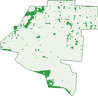
Green: 10 m cells where trees dominate, satellite 2021. Blue: water. The line is the suburb boundary.
| Canopy share, 1 m canopy height map, 2020 | 5.0% |
|---|---|
| Land with trees, 10 m satellite map, 2021 | 6.1% |
Demographics
Unemployment 7.4% · Labour-force participation 55%
Population by age in Midland
| 0-4 | 316 |
|---|---|
| 5-14 | 473 |
| 15-19 | 256 |
| 20-24 | 551 |
| 25-34 | 1,166 |
| 35-44 | 882 |
| 45-54 | 802 |
| 55-64 | 682 |
| 65-74 | 553 |
| 75-84 | 365 |
| 85+ | 275 |
Dwelling types in Midland
| House | 933 |
|---|---|
| Townhouse | 1,468 |
| Apartment | 487 |
| Other | 4 |
Households by weekly income in Midland
| <$650 | 750 |
|---|---|
| $650-1,499 | 972 |
| $1,500-2,999 | 774 |
| $3,000+ | 194 |
Top ancestries in Midland
| English | 2,104 |
|---|---|
| Australian | 1,526 |
| Other | 852 |
| Ancestry NS | 761 |
| Irish | 473 |
| Scottish | 447 |
Housing tenure in Midland
| Owned | 475 |
|---|---|
| Mortgage | 529 |
| Rented | 1,786 |
| Other | 24 |
Cars per household in Midland
| 0 | 439 |
|---|---|
| 1 | 1,502 |
| 2 | 702 |
| 3 | 126 |
| 4+ | 52 |
Commute to work in Midland
| Car | 1,873 |
|---|---|
| Train | 62 |
| Bus | 70 |
| Tram/ferry | 0 |
| Walked | 126 |
| Bicycle | 31 |
| Home | 98 |
Top countries of birth in Midland
| Philippines | 322 |
|---|---|
| New Zealand | 298 |
| England | 282 |
| India | 227 |
| Italy | 98 |
| China | 55 |
Languages used at home in Midland
| Tagalog | 140 |
|---|---|
| Filipino | 121 |
| Italian | 116 |
| Mandarin | 71 |
| Hindi | 67 |
| Punjabi | 59 |
Birds & Wildlife Nearby
43,194 bird observations recorded near Midland — most often seen:
- South-western Australian Magpie (2,275)
- Pacific Black Duck (1,948)
- Laughing Turtle-dove (1,908)
- Twenty-eight Parrot (1,850)
- Australian Wood Duck (1,764)
- Willie Wagtail (1,717)
- Singing Honeyeater (1,676)
- Australian Ringneck (1,641)
- Australian White Ibis (1,641)
- Australian Raven (1,634)
- Western Galah (1,526)
- Rock Dove (1,505)
- Western Australian Raven (1,498)
Show all 30 birds recorded near Midland
- Magpie-lark (1,379)
- Western Brown Honeyeater (1,337)
- South-western Singing Honeyeater (1,320)
- Galah (1,299)
- Southern Magpie-lark (1,288)
- Brown Honeyeater (1,260)
- Eurasian Coot (1,232)
- Rainbow Lorikeet (1,223)
- Western Red Wattlebird (1,222)
- Southern Willie Wagtail (1,210)
- White-faced Heron (1,190)
- Spotted Turtle-dove (1,187)
- Little Corella (1,128)
- Western Striated Pardalote (1,127)
- Red Wattlebird (1,110)
- Grey Teal (1,075)
- Short-billed Black-cockatoo (1,024)
Sightings reported by observers, not a survey, so the counts show what people record rather than what lives here. Source: Atlas of Living Australia.
Nearby Suburbs
The closest suburbs to Midland:
- Viveash (1.4 km)
- Woodbridge (1.6 km)
- Midvale (1.7 km)
- Middle Swan (2.2 km)
- Bellevue (2.3 km)
- Hazelmere (2.9 km)
- Swan View (3.5 km)
- Stratton (3.6 km)
Embed this suburb
Add this free Midland stat card to your own site — just copy the code:
Preview:
Cite this page
Quoting these figures? Copy the credit line:
Keep an eye on Midland
One email when this data meaningfully changes — new census figures, prices, rankings. No spam, unsubscribe anytime.
Streets
- Brockman Road (191)
- Burgess Street (11)
- Byers Road (70)
- Cale Street (22)
- Centennial Place (8)
- Charles East Street (60)
- Charles Street (194)
- Clayton Street (41)
- Cole Street (17)
- Cooper Street (54)
- Cope Street (166)
- Dudley Street (123)
- Eddie Barron Drive (5)
- Egan Place (20)
- Egan Street (1)
- Elgee Road (27)
- Elvire Street (48)
- Eric Street (22)
- Ewart Grove (14)
- Ewart Street (78)
- Fawell Street (38)
- Ferguson Street (112)
- Flora Street (12)
- Foundry Road (119)
- Frances Street (2)
- Frederic Street (108)
- Furl Court (6)
- Gartrell Street (40)
- Gauge Road (1)
- George Street (182)
- Great Eastern Highway (429)
- Great Northern Highway (246)
- Hamersley Street (98)
- Helena Street (74)
- Helston Court (12)
- Henry Street (55)
- Hooley Road (124)
- Hume Court (21)
- Hyde Street (46)
- John Street (174)
- Junction Parade (93)
- Kay Place (34)
- Keane Street (118)
- Kingston Place (19)
- Lamont Street (12)
- Landor Gardens (1)
- Lefroy Avenue (13)
- Lloyd Street (25)
- Loftie Gardens (1)
- Loton Avenue (188)
- Main Gate (8)
- Malton Lane (4)
- Margaret Street (168)
- Marion Street (4)
- Mathoura Street (211)
- Mellar Court (19)
- Midland Square (2)
- Military Road (4)
- Morrison Road (263)
- Muriel Street (11)
- New Bond Street (31)
- North Street (189)
- Oats Court (12)
- Old Great Northern Highway (74)
- Padbury Terrace (27)
- Platingshop Terrace (26)
- Poynton Avenue (7)
- Railway Parade (117)
- Roger Street (33)
- Rowe Place (20)
- Ryan Court (12)
- Sampson Close (67)
- Sayer Street (151)
- Spring Avenue (114)
- Spring Park Road (40)
- St Brigids Place (5)
- Stafford Street (53)
- Taylor Crescent (14)
- Templeman Place (51)
- The Avenue (44)
- The Crescent (241)
- Tuohy Lane (3)
- Victoria Street (92)
- Wallsend Road (44)
- Warde Street (23)
- Warnock Lane (14)
- Watertank Way (3)
- Wellaton Street (43)
- William Street (67)
- Wroxton Street (149)
- Yelverton Drive (15)