Merredin WA 6415
2,156 addresses · 118 streets
O'Connor Electorate › Merredin LGA › Merredin · 235 km from Perth
📦 Thinking of moving here? Read the Merredin moving guide

Living Here
Merredin is a suburb of Western Australia, home to about 2,604 people, with a median age of 40. The typical household earns around $1,396 a week, with median rent near $220 a week. Most homes are houses. About 64% of households own their home and 33% rent. Most workers drive to work. Common community backgrounds include Australian, English, Ancestry NS. On the ABS socio-economic scale it sits in decile 2 of 10 nationally — a more disadvantaged area.
Over time — Census 2001 → 2021
Dashed line: district figures for the Merredin statistical area (SA2), the smallest area the ABS published before 2011. Solid line: Merredin itself.
Getting Around & Local Services
2 schools
1 supermarket
1 Catholic church
1 pharmacy
2 doctors & medical clinics
1 physiotherapist
1 hospital
2 childcare & kindergartens
1 library
1 post office
4 service stations
2 gyms & sports centres
1 golf club
1 dog park
1 bakery
2 hardware stores
2 hairdressers
1 beauty salon
2 electricians
1 carpenter
Getting around. Train station: Merredin, 300 m west.
Socio-economic Standing
Deciles from 1 (lowest) to 10 (highest), against all Australian suburbs. The overall figure weighs advantage and disadvantage together; economic resources counts income and housing, and education & jobs counts qualifications and occupation. They often differ. Source: ABS SEIFA 2021.
Tree cover
🌳 Tree canopy: 6.2% share of land under canopy · satellite map, 2020
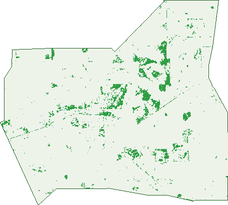
Green: 10 m cells where trees dominate, satellite 2021. Blue: water. The line is the suburb boundary.
| Canopy share, 1 m canopy height map, 2020 | 6.2% |
|---|---|
| Land with trees, 10 m satellite map, 2021 | 5.6% |
Demographics
Unemployment 4.5% · Labour-force participation 58.5%
Population by age in Merredin
| 0-4 | 155 |
|---|---|
| 5-14 | 348 |
| 15-19 | 152 |
| 20-24 | 147 |
| 25-34 | 328 |
| 35-44 | 313 |
| 45-54 | 312 |
| 55-64 | 361 |
| 65-74 | 286 |
| 75-84 | 129 |
| 85+ | 61 |
Dwelling types in Merredin
| House | 927 |
|---|---|
| Townhouse | 43 |
| Apartment | 3 |
| Other | 8 |
Households by weekly income in Merredin
| <$650 | 182 |
|---|---|
| $650-1,499 | 290 |
| $1,500-2,999 | 280 |
| $3,000+ | 127 |
Top ancestries in Merredin
| Australian | 1,102 |
|---|---|
| English | 1,058 |
| Ancestry NS | 294 |
| Scottish | 235 |
| Irish | 198 |
| Aboriginal | 134 |
Housing tenure in Merredin
| Owned | 302 |
|---|---|
| Mortgage | 313 |
| Rented | 314 |
| Other | 27 |
Cars per household in Merredin
| 0 | 60 |
|---|---|
| 1 | 349 |
| 2 | 353 |
| 3 | 140 |
| 4+ | 59 |
Commute to work in Merredin
| Car | 858 |
|---|---|
| Train | 0 |
| Bus | 9 |
| Tram/ferry | 0 |
| Walked | 71 |
| Bicycle | 9 |
| Home | 44 |
Top countries of birth in Merredin
| England | 77 |
|---|---|
| New Zealand | 53 |
| Philippines | 24 |
| South Africa | 14 |
| Zimbabwe | 14 |
| Italy | 13 |
Languages used at home in Merredin
| Italian | 16 |
|---|---|
| Filipino | 14 |
| Malayalam | 10 |
| Tagalog | 10 |
| Afrikaans | 5 |
| Serbian | 5 |
Birds & Wildlife Nearby
2,639 bird observations recorded near Merredin — most often seen:
- Port Lincoln Parrot (165)
- Western Australian Raven (142)
- Australian Raven (139)
- Western Red Wattlebird (122)
- Galah (118)
- Southern Weebill (118)
- Weebill (112)
- Pacific Black Duck (104)
- Red Wattlebird (100)
- Australian Ringneck (92)
- Western Galah (87)
- Western Striated Pardalote (87)
- Eurasian Coot (84)
Show all 30 birds recorded near Merredin
- Magpie-lark (82)
- Western Brown Honeyeater (82)
- Australian Wood Duck (80)
- Yellow-throated Miner (75)
- Grey Teal (73)
- Spiny-cheeked Honeyeater (73)
- Australasian Grebe (71)
- South-western Singing Honeyeater (70)
- South-western Australian Magpie (68)
- Brown Honeyeater (67)
- Red-capped Robin (67)
- Southern Magpie-lark (66)
- Rock Dove (62)
- Western White-eared Honeyeater (61)
- Australian Shelduck (60)
- Willie Wagtail (57)
- Inland Yellow-throated Miner (55)
Sightings reported by observers, not a survey, so the counts show what people record rather than what lives here. Source: Atlas of Living Australia.
Nearby Suburbs
The closest suburbs to Merredin:
- Nangeenan (10.7 km)
- Norpa (13.5 km)
- Nokaning (13.7 km)
- Burracoppin (18.2 km)
- Hines Hill (19.9 km)
- Nukarni (20.4 km)
- Korbel (23.5 km)
- Elabbin (28.6 km)
Embed this suburb
Add this free Merredin stat card to your own site — just copy the code:
Preview:
Cite this page
Quoting these figures? Copy the credit line:
Keep an eye on Merredin
One email when this data meaningfully changes — new census figures, prices, rankings. No spam, unsubscribe anytime.
Streets
- Acacia Way (8)
- Adamson Road (4)
- Alfred Street (9)
- Allbeury Street (4)
- Aspland Street (8)
- Barrack Street (51)
- Bates Street (107)
- Benson Road (5)
- Booran North Road (4)
- Booran South Road (8)
- Bower Street (12)
- Boyd Street (24)
- Brewery Road (2)
- Bruce Rock-merredin Road (6)
- Bulls Head Road (2)
- Bungulla Road (1)
- Carey Street (2)
- Caridi Close (9)
- Carrington Way (15)
- Cassia Street (4)
- Caw Street (76)
- Chandler-merredin Road (11)
- Coghill Street (8)
- Cohn Street (17)
- Colin Street (13)
- Combes Drive (3)
- Coronation Street (49)
- Council Street (16)
- Cowan Way (26)
- Craddock Road (18)
- Cummings Crescent (20)
- Cummings Street (23)
- Cunningham Street (65)
- Davies Street (12)
- Dobson Avenue (22)
- Dolton Way (10)
- Doyle Street (2)
- Duff Street (98)
- Duggan Way (6)
- Eaton Way (1)
- Edwards Street (7)
- Ellis Road (8)
- Endersbee Street (91)
- Farrar Parade (13)
- Fifth Avenue (3)
- Fifth Street (13)
- Fourth Avenue (9)
- French Avenue (43)
- Gabo Avenue (2)
- Gamenya Avenue (26)
- George Street (22)
- Gilmore Road (4)
- Goldfields Road (9)
- Golf Road (20)
- Great Eastern Highway (20)
- Growden Street (41)
- Haig Road (35)
- Haines Street (22)
- Hardy Place (1)
- Harling Street (24)
- Hart Street (24)
- Hawker Way (2)
- Hay Street (29)
- Hicks Road (1)
- Hill Street (7)
- Hobbs Road (8)
- Hopkins Lane (9)
- Hughes Road (7)
- Jackson Way (29)
- Jellicoe Road (13)
- Jubilee Street (12)
- Kendall Street (11)
- King Street (11)
- Kitchener Road (59)
- Kowidgh Way (9)
- Langfield Street (8)
- Lefroy Street (19)
- Lewis Way (6)
- Limbourne Street (9)
- Lukin Street (4)
- Macdonald Street (19)
- Maiolo Way (7)
- Margaret Lane (22)
- Mary Street (3)
- Mcginniss Way (11)
- Merino Street (7)
- Merredin-narembeen Road (8)
- Merredin-nungarin Road (4)
- Mill Street (15)
- Mitchell Street (62)
- Morton Street (14)
- Muscat Street (8)
- Nolan Way (3)
- O'connor Street (4)
- Oat Street (2)
- Pioneers Road (27)
- Pollock Avenue (54)
- Priestley Street (22)
- Princess Street (43)
- Queen Street (6)
- Railway Avenue (29)
- Robartson Road (2)
- Second Avenue (20)
- Snell Street (21)
- Solomon Street (15)
- South Avenue (32)
- Telfer Avenue (1)
- Third Avenue (8)
- Throssell Road (26)
- Todd Street (77)
- Totadgin Hall Road (2)
- Walder Place (3)
- Warne Street (8)
- Watson Road (4)
- Whitehead Court (2)
- Whitfield Way (15)
- Woolgar Avenue (29)
- Yorrell Way (50)