Melville WA 6156
3,162 addresses · 61 streets
Tangney Electorate › Melville LGA › Melville · 11 km from Perth
📦 Thinking of moving here? Read the Melville moving guide

Living Here
Melville is a suburb of Western Australia, home to about 6,204 people, with a median age of 42. The typical household earns around $2,183 a week, with median rent near $420 a week. Most homes are houses. About 83% of households own their home and 16% rent. Most workers drive to work. Common community backgrounds include English, Australian, Irish. On the ABS socio-economic scale it sits in decile 10 of 10 nationally — a relatively advantaged area.
Over time — Census 2001 → 2021
Dashed line: district figures for the Melville statistical area (SA2), the smallest area the ABS published before 2011. Solid line: Melville itself.
Getting Around & Local Services
50 schools
- Melville Primary School
- Melville Senior High School
- Caralee Community School
- Our Lady Of Fatima School
- Mel Maria Catholic Primary School (Pater Noster Campus)
- Mel Maria Catholic Primary School (Saint Joseph Pignatelli Campus)
- Palmyra Primary School
- Bicton Primary School
- Attadale Primary School
- Santa Maria College
3 childcare & kindergartens
1 playground
1 electrician
2 plumbers
Getting around. Train station: North Fremantle, 4.8 km west · Bus interchange: Booragoon Bus Station, 3.4 km east · Ferry wharf: East Street Ferry Jetty, 4.2 km west · Airport: Jandakot Airport, 9.4 km south-east.
Socio-economic Standing
Deciles from 1 (lowest) to 10 (highest), against all Australian suburbs. The overall figure weighs advantage and disadvantage together; economic resources counts income and housing, and education & jobs counts qualifications and occupation. They often differ. Source: ABS SEIFA 2021.
Tree cover
🌳 Tree canopy: 7.8% share of land under canopy · satellite map, 2020
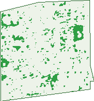
Green: 10 m cells where trees dominate, satellite 2021. Blue: water. The line is the suburb boundary.
| Canopy share, 1 m canopy height map, 2020 | 7.8% |
|---|---|
| Land with trees, 10 m satellite map, 2021 | 5.1% |
Demographics
Unemployment 3.7% · Labour-force participation 68.4%
Population by age in Melville
| 0-4 | 329 |
|---|---|
| 5-14 | 866 |
| 15-19 | 440 |
| 20-24 | 333 |
| 25-34 | 607 |
| 35-44 | 784 |
| 45-54 | 964 |
| 55-64 | 788 |
| 65-74 | 520 |
| 75-84 | 323 |
| 85+ | 248 |
Dwelling types in Melville
| House | 1,790 |
|---|---|
| Townhouse | 437 |
| Apartment | 77 |
| Other | 0 |
Households by weekly income in Melville
| <$650 | 323 |
|---|---|
| $650-1,499 | 454 |
| $1,500-2,999 | 563 |
| $3,000+ | 792 |
Top ancestries in Melville
| English | 2,616 |
|---|---|
| Australian | 2,213 |
| Irish | 749 |
| Scottish | 664 |
| Italian | 628 |
| Other | 577 |
Housing tenure in Melville
| Owned | 888 |
|---|---|
| Mortgage | 1,021 |
| Rented | 355 |
| Other | 23 |
Cars per household in Melville
| 0 | 78 |
|---|---|
| 1 | 727 |
| 2 | 1,040 |
| 3 | 280 |
| 4+ | 152 |
Commute to work in Melville
| Car | 2,214 |
|---|---|
| Train | 22 |
| Bus | 107 |
| Tram/ferry | 0 |
| Walked | 34 |
| Bicycle | 18 |
| Home | 316 |
Top countries of birth in Melville
| England | 428 |
|---|---|
| New Zealand | 108 |
| South Africa | 64 |
| Italy | 54 |
| Scotland | 50 |
| Malaysia | 48 |
Languages used at home in Melville
| Italian | 82 |
|---|---|
| Mandarin | 55 |
| Indonesian | 40 |
| Spanish | 33 |
| Arabic | 32 |
| Portuguese | 29 |
Birds & Wildlife Nearby
113,192 bird observations recorded near Melville — most often seen:
- Laughing Turtle-dove (5,312)
- South-western Australian Magpie (5,295)
- Pacific Black Duck (4,943)
- Australian White Ibis (4,829)
- Western Red Wattlebird (4,787)
- Black Swan (4,609)
- South-western Singing Honeyeater (4,569)
- Eastern Rainbow Lorikeet (4,554)
- Willie Wagtail (4,526)
- Western Australian Raven (4,477)
- Australian Raven (4,355)
- Rainbow Lorikeet (4,289)
- Little Pied Cormorant (4,152)
Show all 30 birds recorded near Melville
- Red Wattlebird (4,029)
- Australian Pelican (3,598)
- Eastern Asian Spotted Dove (3,444)
- Singing Honeyeater (3,354)
- Southern Willie Wagtail (3,275)
- Twenty-eight Parrot (3,269)
- Western Brown Honeyeater (3,172)
- Southern Magpie-lark (3,130)
- Australian Magpie (3,026)
- Silver Gull (3,024)
- White-faced Heron (3,016)
- Galah (2,924)
- Grey Teal (2,818)
- Little Black Cormorant (2,661)
- Welcome Swallow (2,638)
- Australian Shelduck (2,600)
- Australian Pied Oystercatcher (2,517)
Sightings reported by observers, not a survey, so the counts show what people record rather than what lives here. Source: Atlas of Living Australia.
Nearby Suburbs
The closest suburbs to Melville:
Embed this suburb
Add this free Melville stat card to your own site — just copy the code:
Preview:
Cite this page
Quoting these figures? Copy the credit line:
Keep an eye on Melville
One email when this data meaningfully changes — new census figures, prices, rankings. No spam, unsubscribe anytime.
Streets
- Arney Place (13)
- Birdwood Road (83)
- Bowling Place (20)
- Bridges Road (122)
- Brooksby Street (27)
- Canning Highway (170)
- Cardew Street (25)
- Challenger Place (73)
- Coleman Crescent (169)
- Curtis Place (17)
- Curtis Road (47)
- Freeman Street (18)
- French Road (48)
- Gimber Street (21)
- Guy Place (20)
- Halse Crescent (47)
- Head Street (13)
- Holman Street (73)
- Hopgood Street (29)
- Hornsby Street (33)
- Howarth Street (9)
- Isaac Street (20)
- Jason Street (19)
- Joiner Street (97)
- Kemmish Crescent (38)
- Kennedy Street (71)
- Kirkland Place (24)
- Kitchener Road (204)
- Knox Crescent (38)
- Lamond Street (70)
- Leach Highway (60)
- Luffingham Street (45)
- Maddox Crescent (17)
- Marmion Court (10)
- Marmion Street (201)
- Mccoy Street (42)
- Mcknight Place (9)
- Mclean Street (70)
- Melview Court (20)
- Money Place (12)
- Money Road (107)
- Olding Street (35)
- Olding Way (27)
- Perkins Road (56)
- Potts Street (65)
- Prinsep Road (43)
- Redwood Crescent (110)
- Renton Street (22)
- Rome Road (136)
- Sergeant Road (52)
- Shelshaw Street (58)
- Stock Road (27)
- Thorn Street (4)
- Thurso Road (3)
- Troytown Way (21)
- Widdicombe Street (1)
- Williams Court (14)
- Williams Road (86)
- Windfield Road (48)
- Woodley Crescent (64)
- Young Street (39)