Mckail WA 6330
1,909 addresses · 90 streets
O'Connor Electorate › Albany LGA › Mckail · 385 km from Perth
📦 Thinking of moving here? Read the Mckail moving guide

Living Here
Mckail is a suburb of Western Australia, home to about 3,970 people, with a median age of 34. The typical household earns around $1,641 a week, with median rent near $350 a week. Most homes are houses. About 74% of households own their home and 25% rent. Most workers drive to work. Common community backgrounds include English, Australian, Scottish. On the ABS socio-economic scale it sits in decile 3 of 10 nationally — a more disadvantaged area.
Over time — Census 2001 → 2021
Dashed line: district figures for the McKail - Willyung statistical area (SA2), the smallest area the ABS published before 2011. Solid line: Mckail itself.
Getting Around & Local Services
2 cafés & restaurants
1 supermarket
1 Catholic church
3 optometrists
2 hospitals
1 vet
1 childcare centre
1 library
9 service stations
2 gyms & sports centres
1 golf club
4 hardware stores
Getting around. Airport: Albany Regional Airport, 5.7 km north-west.
Socio-economic Standing
Deciles from 1 (lowest) to 10 (highest), against all Australian suburbs. The overall figure weighs advantage and disadvantage together; economic resources counts income and housing, and education & jobs counts qualifications and occupation. They often differ. Source: ABS SEIFA 2021.
Tree cover
🌳 Tree canopy: 19.6% share of land under canopy · satellite map, 2020
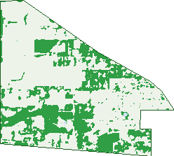
Green: 10 m cells where trees dominate, satellite 2021. Blue: water. The line is the suburb boundary.
| Canopy share, 1 m canopy height map, 2020 | 19.6% |
|---|---|
| Land with trees, 10 m satellite map, 2021 | 31.5% |
Demographics
Unemployment 4% · Labour-force participation 67%
Population by age in Mckail
| 0-4 | 323 |
|---|---|
| 5-14 | 641 |
| 15-19 | 269 |
| 20-24 | 251 |
| 25-34 | 548 |
| 35-44 | 555 |
| 45-54 | 492 |
| 55-64 | 392 |
| 65-74 | 312 |
| 75-84 | 165 |
| 85+ | 32 |
Dwelling types in Mckail
| House | 1,329 |
|---|---|
| Townhouse | 22 |
| Apartment | 3 |
| Other | 0 |
Households by weekly income in Mckail
| <$650 | 168 |
|---|---|
| $650-1,499 | 381 |
| $1,500-2,999 | 485 |
| $3,000+ | 169 |
Top ancestries in Mckail
| English | 1,810 |
|---|---|
| Australian | 1,676 |
| Scottish | 347 |
| Irish | 274 |
| Other | 272 |
| Filipino | 190 |
Housing tenure in Mckail
| Owned | 342 |
|---|---|
| Mortgage | 645 |
| Rented | 338 |
| Other | 10 |
Cars per household in Mckail
| 0 | 31 |
|---|---|
| 1 | 346 |
| 2 | 642 |
| 3 | 209 |
| 4+ | 117 |
Commute to work in Mckail
| Car | 1,574 |
|---|---|
| Train | 0 |
| Bus | 17 |
| Tram/ferry | 0 |
| Walked | 5 |
| Bicycle | 7 |
| Home | 55 |
Top countries of birth in Mckail
| England | 180 |
|---|---|
| Philippines | 155 |
| New Zealand | 63 |
| South Africa | 55 |
| Thailand | 36 |
| Myanmar | 33 |
Languages used at home in Mckail
| Tagalog | 62 |
|---|---|
| Filipino | 50 |
| Afrikaans | 40 |
| Italian | 16 |
| Malayalam | 12 |
| Australian Indigenous | 8 |
Birds & Wildlife Nearby
3,923 bird observations recorded near Mckail — most often seen:
- Common Bronzewing (261)
- Red-capped Parrot (192)
- Australian White Ibis (190)
- New Holland Honeyeater (188)
- Australian Magpie (170)
- South-western New Holland Honeyeater (165)
- Straw-necked Ibis (159)
- South-western Australian Magpie (153)
- Western Silvereye (142)
- Red Wattlebird (141)
- Red-winged Fairy-wren (132)
- Pacific Black Duck (125)
- Australian Raven (124)
Show all 30 birds recorded near Mckail
- Western Red Wattlebird (124)
- White-faced Heron (120)
- Red-eared Firetail (117)
- Australian Pelican (114)
- Western Australian Raven (114)
- Western Spinebill (114)
- Western Rosella (108)
- Silvereye (104)
- South-western Grey Fantail (103)
- South-western Spotted Scrubwren (102)
- Southern Magpie-lark (100)
- Willie Wagtail (100)
- Magpie-lark (98)
- Laughing Turtle-dove (96)
- Giinbaywarraymal (92)
- South-west Western Rosella (89)
- Southern Willie Wagtail (86)
Sightings reported by observers, not a survey, so the counts show what people record rather than what lives here. Source: Atlas of Living Australia.
Nearby Suburbs
The closest suburbs to Mckail:
- Orana (1.6 km)
- Gledhow (1.8 km)
- Warrenup (2 km)
- Lockyer (2.1 km)
- Milpara (2.2 km)
- Yakamia (3.6 km)
- Mount Melville (3.9 km)
- Mount Elphinstone (4.1 km)
Embed this suburb
Add this free Mckail stat card to your own site — just copy the code:
Preview:
Cite this page
Quoting these figures? Copy the credit line:
Keep an eye on Mckail
One email when this data meaningfully changes — new census figures, prices, rankings. No spam, unsubscribe anytime.
Streets
- Albany Highway (58)
- Alfred Street (40)
- Aquarius Road (9)
- Ash Way (4)
- Aurora Rise (14)
- Beal Lane (3)
- Beaudon Road (16)
- Boorara Way (34)
- Boundary Street (21)
- Brady Corner (13)
- Bylund Way (17)
- Celestial Drive (42)
- Centaurus Terrace (53)
- Cleave Close (18)
- Clydesdale Road (44)
- Comet Corner (40)
- Conifer Lane (9)
- Cordery Way (4)
- Cordillera Street (10)
- Costigan Street (13)
- Crispe Way (16)
- Donald Drive (29)
- Dorado Bend (23)
- Drome Road (37)
- Dustan Way (15)
- Edinburgh Road (47)
- Elm Walk (5)
- Endeavour Way (9)
- Engleheart Drive (27)
- Etchinson Link (6)
- Ethereal Drive (30)
- Federal Street (37)
- Flemington Street (9)
- Gerdes Way (27)
- Gladville Road (35)
- Goddard Way (20)
- Gregory Drive (34)
- Hankins Way (13)
- Hogarth Road (12)
- Junction Street (16)
- Jupiter Way (20)
- Kitcher Parade (26)
- Lakeside Drive (25)
- Lancaster Road (118)
- Le Grande Avenue (15)
- Leo Lane (4)
- Link Road (2)
- Little Henry Street (3)
- Littleheart Place (13)
- Lunar Rise (19)
- Maritime Avenue (8)
- Mcgonnell Road (47)
- Mckail Road (6)
- Mcneal Loop (39)
- Mercury Way (3)
- Meteor Lane (1)
- Milky Way (4)
- Moncrieff Road (4)
- Moon Parade (19)
- Morgan Place (10)
- Morgan Road (17)
- Neptune Pass (13)
- O'keefe Parade (29)
- Oak Court (8)
- Orion Avenue (45)
- Parmelia Way (26)
- Patricia Close (3)
- Pegasus Boulevard (42)
- Penter Way (6)
- Pluto Rise (23)
- Pyungoorup Place (2)
- Radiata Drive (79)
- Reddale Road (2)
- Roome Road (8)
- Salisbury Road (17)
- Satellite Close (13)
- Scorpio Drive (51)
- Sherwood Drive (40)
- Silver Street (22)
- South Coast Highway (43)
- Starlight Place (2)
- Stoddart Corner (20)
- Timewell Road (5)
- Todd Road (18)
- Trio Crescent (33)
- Venus Lane (2)
- Vernon Lane (20)
- Webb Street (14)
- Withers Way (6)
- Yew Court (5)