Lamington WA 6430
924 addresses · 21 streets
O'Connor Electorate › Kalgoorlie-Boulder LGA › Lamington · 549 km from Perth
📦 Thinking of moving here? Read the Lamington moving guide

Living Here
Lamington is a suburb of Western Australia, home to about 2,036 people, with a median age of 33. The typical household earns around $2,886 a week, with median rent near $370 a week. Most homes are houses. About 69% of households own their home and 29% rent. Most workers drive to work. Common community backgrounds include Australian, English, Scottish. On the ABS socio-economic scale it sits in decile 9 of 10 nationally — a relatively advantaged area.
Over time — Census 2001 → 2021
Dashed line: district figures for the Kalgoorlie - North statistical area (SA2), the smallest area the ABS published before 2011. Solid line: Lamington itself.
Getting Around & Local Services
4 supermarkets
1 Catholic church
2 pharmacies
1 medical clinic
1 hospital
1 library
1 post office
5 service stations
3 gyms & sports centres
1 golf club
1 bakery
2 butchers
1 hardware store
Getting around. Train station: Kalgoorlie, 1.4 km south · Airport: Kalgoorlie-Boulder Airport, 5.9 km south.
Socio-economic Standing
Deciles from 1 (lowest) to 10 (highest), against all Australian suburbs. The overall figure weighs advantage and disadvantage together; economic resources counts income and housing, and education & jobs counts qualifications and occupation. They often differ. Source: ABS SEIFA 2021.
Tree cover
🌳 Tree canopy: 3.7% share of land under canopy · satellite map, 2020
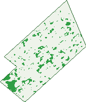
Green: 10 m cells where trees dominate, satellite 2021. Blue: water. The line is the suburb boundary.
| Canopy share, 1 m canopy height map, 2020 | 3.7% |
|---|---|
| Land with trees, 10 m satellite map, 2021 | 5.9% |
Demographics
Unemployment 2% · Labour-force participation 74.8%
Population by age in Lamington
| 0-4 | 162 |
|---|---|
| 5-14 | 313 |
| 15-19 | 102 |
| 20-24 | 132 |
| 25-34 | 339 |
| 35-44 | 299 |
| 45-54 | 273 |
| 55-64 | 251 |
| 65-74 | 89 |
| 75-84 | 49 |
| 85+ | 17 |
Dwelling types in Lamington
| House | 676 |
|---|---|
| Townhouse | 27 |
| Apartment | 0 |
| Other | 0 |
Households by weekly income in Lamington
| <$650 | 53 |
|---|---|
| $650-1,499 | 79 |
| $1,500-2,999 | 202 |
| $3,000+ | 296 |
Top ancestries in Lamington
| Australian | 861 |
|---|---|
| English | 717 |
| Scottish | 224 |
| Irish | 208 |
| Other | 153 |
| Ancestry NS | 142 |
Housing tenure in Lamington
| Owned | 141 |
|---|---|
| Mortgage | 337 |
| Rented | 201 |
| Other | 9 |
Cars per household in Lamington
| 0 | 17 |
|---|---|
| 1 | 183 |
| 2 | 295 |
| 3 | 121 |
| 4+ | 63 |
Commute to work in Lamington
| Car | 939 |
|---|---|
| Train | 0 |
| Bus | 21 |
| Tram/ferry | 0 |
| Walked | 15 |
| Bicycle | 7 |
| Home | 27 |
Top countries of birth in Lamington
| New Zealand | 99 |
|---|---|
| England | 58 |
| South Africa | 23 |
| Philippines | 22 |
| India | 19 |
| Ireland | 15 |
Languages used at home in Lamington
| Afrikaans | 23 |
|---|---|
| German | 13 |
| Malayalam | 12 |
| Australian Indigenous | 10 |
| Mandarin | 10 |
| Urdu | 9 |
Birds & Wildlife Nearby
6,327 bird observations recorded near Lamington — most often seen:
- Inland Singing Honeyeater (383)
- Western Brown Honeyeater (359)
- Red Wattlebird (330)
- Western Red Wattlebird (321)
- Magpie-lark (303)
- Galah (299)
- Laughing Turtle-dove (282)
- Australian Raven (273)
- Australian Ringneck (266)
- Port Lincoln Parrot (265)
- Southern Weebill (260)
- Singing Honeyeater (256)
- Grey Currawong (225)
Show all 30 birds recorded near Lamington
- Western Striated Pardalote (213)
- Brown Honeyeater (207)
- South-western Grey Currawong (180)
- Willie Wagtail (180)
- Western Australian Raven (175)
- Southern Magpie-lark (170)
- Yellow-plumed Honeyeater (167)
- Yellow-throated Miner (150)
- Spiny-cheeked Honeyeater (144)
- Pied Butcherbird (130)
- Inland Yellow-throated Miner (125)
- Weebill (125)
- Western Galah (113)
- Southern Willie Wagtail (112)
- Pacific Black Duck (110)
- Rock Dove (106)
- Crested Pigeon (98)
Sightings reported by observers, not a survey, so the counts show what people record rather than what lives here. Source: Atlas of Living Australia.
Nearby Suburbs
The closest suburbs to Lamington:
- Mullingar (0.8 km)
- Piccadilly (0.9 km)
- Hannans (1.2 km)
- Karlkurla (1.3 km)
- West Lamington (1.6 km)
- Kalgoorlie (2 km)
- Williamstown (2.4 km)
- Parkeston (3.2 km)
Embed this suburb
Add this free Lamington stat card to your own site — just copy the code:
Preview:
Cite this page
Quoting these figures? Copy the credit line:
Keep an eye on Lamington
One email when this data meaningfully changes — new census figures, prices, rankings. No spam, unsubscribe anytime.
Streets
- Addis Street (126)
- Alderdice Place (7)
- Butterfly Street (8)
- Campbell Street (150)
- Elliott Place (3)
- Graeme Street (25)
- Hare Street (72)
- Harley Street (2)
- Keenan Street (18)
- Killarney Street (81)
- Lewis Street (133)
- Lyall Street (132)
- Mckenzie Street (4)
- Memorial Drive (2)
- Mostyn Street (1)
- Murray Street (9)
- Parsons Street (4)
- Russell Street (8)
- St Albans Road (3)
- Thurmott Street (5)
- Ward Street (131)