Kununurra WA 6743
3,066 addresses · 150 streets
Durack Electorate › Wyndham-East Kimberley LGA › Kununurra · 2221 km from Perth
📦 Thinking of moving here? Read the Kununurra moving guide

Living Here
Kununurra is a suburb of Western Australia, home to about 5,494 people, with a median age of 33. The typical household earns around $2,091 a week, with median rent near $266 a week. Most homes are houses. About 33% of households own their home and 62% rent. Most workers drive to work. Common community backgrounds include Australian, English, Aboriginal. On the ABS socio-economic scale it sits in decile 5 of 10 nationally — a mid-range area.
Over time — Census 2001 → 2021
Dashed line: district figures for the Kununurra statistical area (SA2), the smallest area the ABS published before 2011. Solid line: Kununurra itself.
Getting Around & Local Services
6 cafés & restaurants
2 supermarkets
1 Catholic church
1 pharmacy
1 vet
1 childcare centre
1 library
1 post office
2 gyms & sports centres
1 golf club
2 hardware stores
Getting around. Airport: East Kimberley Regional Airport, 3.6 km west.
Socio-economic Standing
Deciles from 1 (lowest) to 10 (highest), against all Australian suburbs. The overall figure weighs advantage and disadvantage together; economic resources counts income and housing, and education & jobs counts qualifications and occupation. They often differ. Source: ABS SEIFA 2021.
Tree cover
🌳 Tree canopy: 10.8% share of land under canopy · satellite map, 2020
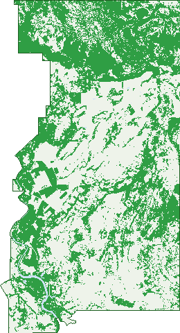
Green: 10 m cells where trees dominate, satellite 2021. Blue: water. The line is the suburb boundary.
| Canopy share, 1 m canopy height map, 2020 | 10.8% |
|---|---|
| Land with trees, 10 m satellite map, 2021 | 43.5% |
Demographics
Unemployment 3.1% · Labour-force participation 63.3%
Population by age in Kununurra
| 0-4 | 406 |
|---|---|
| 5-14 | 856 |
| 15-19 | 267 |
| 20-24 | 318 |
| 25-34 | 1,010 |
| 35-44 | 795 |
| 45-54 | 778 |
| 55-64 | 661 |
| 65-74 | 291 |
| 75-84 | 92 |
| 85+ | 21 |
Dwelling types in Kununurra
| House | 1,031 |
|---|---|
| Townhouse | 225 |
| Apartment | 117 |
| Other | 178 |
Households by weekly income in Kununurra
| <$650 | 157 |
|---|---|
| $650-1,499 | 290 |
| $1,500-2,999 | 538 |
| $3,000+ | 376 |
Top ancestries in Kununurra
| Australian | 1,557 |
|---|---|
| English | 1,528 |
| Aboriginal | 1,270 |
| Ancestry NS | 966 |
| Irish | 421 |
| Other | 398 |
Housing tenure in Kununurra
| Owned | 225 |
|---|---|
| Mortgage | 282 |
| Rented | 953 |
| Other | 68 |
Cars per household in Kununurra
| 0 | 160 |
|---|---|
| 1 | 524 |
| 2 | 524 |
| 3 | 194 |
| 4+ | 123 |
Commute to work in Kununurra
| Car | 1,830 |
|---|---|
| Train | 0 |
| Bus | 24 |
| Tram/ferry | 0 |
| Walked | 247 |
| Bicycle | 55 |
| Home | 102 |
Top countries of birth in Kununurra
| England | 176 |
|---|---|
| New Zealand | 87 |
| Philippines | 39 |
| India | 35 |
| France | 32 |
| Germany | 31 |
Languages used at home in Kununurra
| Australian Indigenous | 233 |
|---|---|
| French | 37 |
| German | 37 |
| Mandarin | 31 |
| Filipino | 22 |
| Vietnamese | 21 |
Birds & Wildlife Nearby
44,256 bird observations recorded near Kununurra — most often seen:
- Bar-shouldered Dove (2,534)
- Black Kite (2,392)
- Rainbow Bee-eater (2,312)
- Peaceful Dove (2,281)
- White-gaped Honeyeater (2,234)
- Magpie-lark (2,056)
- Brown Honeyeater (1,985)
- Crimson Finch (1,937)
- Masked Lapwing (1,860)
- Great Bowerbird (1,748)
- Comb-crested Jacana (1,689)
- Straw-necked Ibis (1,677)
- Whistling Kite (1,621)
Show all 30 birds recorded near Kununurra
- Red-collared Lorikeet (1,593)
- White-breasted Woodswallow (1,431)
- Little Pied Cormorant (1,267)
- Australasian Purple Swamphen (1,251)
- Australasian Darter (1,180)
- Rufous-throated Honeyeater (1,168)
- Double-barred Finch (1,160)
- Blue-faced Honeyeater (1,085)
- Red-winged Parrot (1,006)
- Australian Reed Warbler (931)
- Blue-winged Kookaburra (928)
- Green Pygmy-goose (864)
- White-bellied Cuckoo-shrike (841)
- Little Black Cormorant (833)
- Sacred Kingfisher (824)
- Grey-crowned Babbler (804)
- Yellow Oriole (764)
Sightings reported by observers, not a survey, so the counts show what people record rather than what lives here. Source: Atlas of Living Australia.
Nearby Suburbs
The closest suburbs to Kununurra:
- Lake Argyle (34.2 km)
Embed this suburb
Add this free Kununurra stat card to your own site — just copy the code:
Preview:
Cite this page
Quoting these figures? Copy the credit line:
Keep an eye on Kununurra
One email when this data meaningfully changes — new census figures, prices, rankings. No spam, unsubscribe anytime.
Streets
- Acacia Court (12)
- Alba Street (5)
- Argentea Avenue (37)
- Aspera Street (4)
- Atalaya Court (6)
- Bandicoot Drive (79)
- Banksia Street (3)
- Banyan Street (20)
- Barding Loop (38)
- Barringtonia Avenue (92)
- Bauhinia Street (16)
- Beefwood Street (44)
- Bella Lane (14)
- Bloodwood Drive (23)
- Bluegrass Avenue (12)
- Boobialla Way (39)
- Boompa Court (5)
- Bossea Street (21)
- Bull Run Road (6)
- Button Drive (9)
- Cajuput Street (20)
- Calatropis Court (12)
- Caldesia Loop (15)
- Calytrix Avenue (19)
- Carbeen Street (31)
- Carpentaria Street (12)
- Cassia Street (1)
- Casuarina Way (127)
- Celtis Street (17)
- Chamberlain Drive (4)
- Cherubin Road (8)
- Chestnut Avenue (17)
- Cocus Way (8)
- Coleus Close (14)
- Collina Way (15)
- Coolibah Drive (101)
- Coral Close (21)
- Corkwood Court (17)
- Corkybark Drive (13)
- Cotton Tree Avenue (8)
- Crossing Falls Road (1)
- Cycas Close (14)
- Dentata Street (3)
- Derrinding Way (6)
- Dianella Way (11)
- Dryandra Road (37)
- Drysdale Approach (3)
- Durack Drive (16)
- Dusty Rankin Drive (1)
- Ebony Street (2)
- Egret Close (14)
- Emu Apple Street (11)
- Erythrina Street (96)
- Eucalyptus Close (40)
- Eugenia Street (25)
- Fish Farm Road (3)
- Flametree Street (26)
- Frangipani Court (7)
- Gardenia Drive (23)
- Garrjang Close (4)
- Ghost Gum Street (24)
- Gregorii Street (8)
- Grevillea Avenue (33)
- Greybox Crescent (38)
- Harrier Close (3)
- Hibiscus Drive (33)
- Hovea Street (1)
- Ironwood Drive (26)
- Ivanhoe Road (12)
- Jabiru Road (17)
- Jasmine Lane (14)
- Jilingbang Link (5)
- Kapok Court (8)
- Kentia Way (7)
- Kestrel Place (5)
- Konkerberry Drive (144)
- Koolparn Court (16)
- Kurrajong Street (21)
- Laine Jones Drive (2)
- Leichhardt Street (44)
- Lemonwood Way (42)
- Lirata Pass (4)
- Livistona Street (29)
- Lotus Court (17)
- Lovegrass Way (8)
- Mallee Court (21)
- Mangaloo Street (13)
- Mango Street (14)
- Mangrove Street (3)
- Mcdonald Street (1)
- Melaleuca Drive (18)
- Messmate Way (51)
- Milkwood Street (11)
- Mills Road (12)
- Miniata Street (19)
- Minjiljirrga Lane (4)
- Mistletoe Avenue (29)
- Moonamang Road (1)
- Mulga Street (9)
- Mulligans Lagoon Road (7)
- Nauclea Way (13)
- Nutwood Crescent (38)
- Old Darwin Road (3)
- Oolrui Road (4)
- Packsaddle Road (51)
- Palm Court (19)
- Pandanus Avenue (11)
- Papuana Street (11)
- Pardalote Close (9)
- Pentecost Elbow (1)
- Phoenicea Link (12)
- Pindan Avenue (31)
- Pine Court (12)
- Plum Court (25)
- Poincettia Way (41)
- Poinciana Street (23)
- Pruinosa Street (4)
- Quondong Street (17)
- Rain Tree Street (1)
- Rattlepod Close (14)
- Research Station Road (6)
- River Farm Road (26)
- River Fig Avenue (105)
- River Gum Avenue (13)
- Rosella Close (5)
- Rosewood Avenue (33)
- Salacca Loop (18)
- Sandalwood Street (27)
- Setosa Pass (24)
- Sheoak Street (1)
- Silverbox Avenue (24)
- Sorghum Place (12)
- Speargrass Road (3)
- Spinifex Street (5)
- St Martins Way (1)
- Stock Route Road (2)
- Tamarind Meander (21)
- Teal Road (3)
- Templetonia Banan (6)
- Tristania Street (4)
- Victoria Highway (75)
- Water Lily Place (17)
- Weaber Plain Road (74)
- Weero Road (3)
- Whimbrel Road (38)
- White Gum Street (2)
- Whitewood Street (6)
- Wilga Place (18)
- Woollybutt Place (21)
- Zamia Link (51)