Heathridge WA 6027
3,178 addresses · 154 streets
Moore Electorate › Joondalup LGA › Heathridge · 23 km from Perth
📦 Thinking of moving here? Read the Heathridge moving guide

Living Here
Heathridge is a suburb of Western Australia, home to about 6,898 people, with a median age of 36. The typical household earns around $1,782 a week, with median rent near $370 a week. Most homes are houses. About 75% of households own their home and 24% rent. Most workers drive to work. Common community backgrounds include English, Australian, Irish. On the ABS socio-economic scale it sits in decile 6 of 10 nationally — a mid-range area.
Over time — Census 2001 → 2021
Dashed line: district figures for the Heathridge - Connolly statistical area (SA2), the smallest area the ABS published before 2011. Solid line: Heathridge itself.
Getting Around & Local Services
2 Catholic churches
2 optometrists
3 post offices
2 playgrounds
1 dog park
1 bakery
2 butchers
2 hairdressers
1 electrician
1 plumber
1 carpenter
Getting around. Train station: Edgewater, 2 km south-east · Bus interchange: Whitfords Bus Terminal, 4.5 km south-east · Ferry wharf: Rottnest Ferry, 7 km south · Airport: Perth Airport, 27.7 km south-east.
Socio-economic Standing
Deciles from 1 (lowest) to 10 (highest), against all Australian suburbs. The overall figure weighs advantage and disadvantage together; economic resources counts income and housing, and education & jobs counts qualifications and occupation. They often differ. Source: ABS SEIFA 2021.
Tree cover
🌳 Tree canopy: 9.7% share of land under canopy · satellite map, 2020
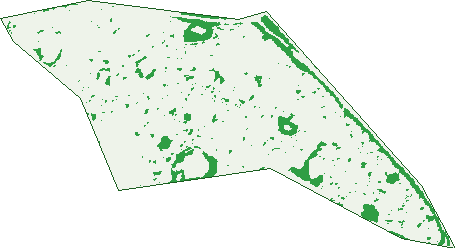
Green: 10 m cells where trees dominate, satellite 2021. Blue: water. The line is the suburb boundary.
| Canopy share, 1 m canopy height map, 2020 | 9.7% |
|---|---|
| Land with trees, 10 m satellite map, 2021 | 7.7% |
Demographics
Unemployment 4.9% · Labour-force participation 68.4%
Population by age in Heathridge
| 0-4 | 497 |
|---|---|
| 5-14 | 913 |
| 15-19 | 325 |
| 20-24 | 382 |
| 25-34 | 1,155 |
| 35-44 | 1,154 |
| 45-54 | 810 |
| 55-64 | 735 |
| 65-74 | 624 |
| 75-84 | 239 |
| 85+ | 71 |
Dwelling types in Heathridge
| House | 2,438 |
|---|---|
| Townhouse | 210 |
| Apartment | 3 |
| Other | 0 |
Households by weekly income in Heathridge
| <$650 | 347 |
|---|---|
| $650-1,499 | 671 |
| $1,500-2,999 | 906 |
| $3,000+ | 498 |
Top ancestries in Heathridge
| English | 3,128 |
|---|---|
| Australian | 2,377 |
| Irish | 794 |
| Other | 666 |
| Scottish | 651 |
| Ancestry NS | 353 |
Housing tenure in Heathridge
| Owned | 678 |
|---|---|
| Mortgage | 1,301 |
| Rented | 627 |
| Other | 24 |
Cars per household in Heathridge
| 0 | 79 |
|---|---|
| 1 | 868 |
| 2 | 1,174 |
| 3 | 343 |
| 4+ | 165 |
Commute to work in Heathridge
| Car | 2,427 |
|---|---|
| Train | 123 |
| Bus | 47 |
| Tram/ferry | 0 |
| Walked | 32 |
| Bicycle | 15 |
| Home | 235 |
Top countries of birth in Heathridge
| England | 811 |
|---|---|
| New Zealand | 223 |
| South Africa | 123 |
| Ireland | 113 |
| Scotland | 91 |
| India | 47 |
Languages used at home in Heathridge
| Mandarin | 54 |
|---|---|
| Italian | 41 |
| Portuguese | 35 |
| Spanish | 33 |
| Afrikaans | 32 |
| Arabic | 31 |
Birds & Wildlife Nearby
59,450 bird observations recorded near Heathridge — most often seen:
- Pacific Black Duck (3,242)
- Eurasian Coot (2,935)
- Black Swan (2,742)
- Australian White Ibis (2,695)
- Musk Duck (2,597)
- Australian Raven (2,481)
- Little Pied Cormorant (2,384)
- Red Wattlebird (2,210)
- Rainbow Lorikeet (2,102)
- Australian Pelican (2,047)
- Galah (2,014)
- Little Black Cormorant (2,008)
- Willie Wagtail (1,913)
Show all 30 birds recorded near Heathridge
- Grey Teal (1,848)
- South-western Australian Magpie (1,836)
- White-faced Heron (1,829)
- Australian Shelduck (1,810)
- Rock Dove (1,803)
- Australian Wood Duck (1,797)
- Australian Magpie (1,768)
- Little Corella (1,680)
- Whistling Kite (1,656)
- Australasian Grebe (1,637)
- Western Red Wattlebird (1,614)
- Western Australian Raven (1,569)
- Great Egret (1,533)
- Eastern Rainbow Lorikeet (1,465)
- Grey Butcherbird (1,459)
- Hoary-headed Grebe (1,432)
- Long-billed Corella (1,344)
Sightings reported by observers, not a survey, so the counts show what people record rather than what lives here. Source: Atlas of Living Australia.
Nearby Suburbs
The closest suburbs to Heathridge:
Embed this suburb
Add this free Heathridge stat card to your own site — just copy the code:
Preview:
Cite this page
Quoting these figures? Copy the credit line:
Keep an eye on Heathridge
One email when this data meaningfully changes — new census figures, prices, rankings. No spam, unsubscribe anytime.
Streets
- Abrolhos Drive (22)
- Acara Court (7)
- Admiral Grove (86)
- Albatross Court (12)
- Ashburton Drive (26)
- Balanus Way (68)
- Balmain Way (28)
- Bayou Court (21)
- Bell Court (5)
- Belvon Court (3)
- Berkeley Street (22)
- Blythewood Way (28)
- Brewis Court (5)
- Busycon Place (16)
- Cane Place (8)
- Caprella Street (24)
- Caprice Place (17)
- Captain Court (15)
- Caridean Street (209)
- Carnac Way (5)
- Carson Place (11)
- Centaur Gardens (7)
- Chamberlain Place (15)
- Channel Drive (56)
- Chiton Place (18)
- Christmas Avenue (53)
- Clayton Close (4)
- Conidae Drive (89)
- Conway Grove (16)
- Coongan Court (8)
- Coquina Close (17)
- Cormorant Court (15)
- Corona Court (6)
- Corsair Court (13)
- Crawley Grove (16)
- Cruise Court (21)
- Culham Gardens (6)
- Dardanus Way (46)
- Davis Place (23)
- Day Place (6)
- De Grey Court (24)
- Deepdene Close (9)
- Deltoid Place (12)
- Diemen Court (11)
- Dirk Hartog Cove (16)
- Dolium Court (7)
- Dosinia Place (9)
- Draconis Street (14)
- Drummer Way (30)
- Dunham Way (20)
- Eddystone Avenue (34)
- Ellendale Drive (46)
- Estuary Way (22)
- Exodon Place (16)
- Fairfield Grove (13)
- Fairlawn Gardens (20)
- Fathom Court (9)
- Faversham Way (16)
- Firebush Court (7)
- Fitzroy Place (16)
- Flotilla Drive (37)
- Fortescue Loop (32)
- Gallop Close (12)
- Grevillea Place (7)
- Grevillea Way (35)
- Henton Place (6)
- Hyacinth Close (10)
- Idyll Court (8)
- Ironwood Avenue (25)
- Isdell Place (7)
- Island Place (16)
- Janthina Crescent (23)
- Jetty Place (18)
- Kalgan Close (10)
- King Edward Drive (53)
- Kingston Close (6)
- Kochia Court (11)
- Lamarck Place (11)
- Larkspur Place (16)
- Lebeo Court (6)
- Lepas Street (2)
- Leucosia Court (11)
- Littorina Avenue (81)
- Logue Court (5)
- Lucine Court (10)
- Lyndon Court (7)
- Lyons Place (8)
- Lysander Drive (77)
- Mangowine Close (12)
- Margaret Place (10)
- Martinup Court (12)
- Marybrook Road (27)
- Meda Place (5)
- Melo Court (5)
- Mermaid Way (44)
- Minilya Street (1)
- Montebello Avenue (61)
- Nandus Court (9)
- Nemesia Court (4)
- Neon Court (13)
- Nerita Place (6)
- Noetia Court (12)
- Norlup Place (6)
- Oakover Way (53)
- Ord Road (2)
- Pageant Loop (29)
- Panjada Place (11)
- Pecten Close (9)
- Pelican Place (6)
- Pelsart Place (12)
- Penguin Close (26)
- Peninsula Avenue (43)
- Penion Close (5)
- Plankton Place (27)
- Pompano Court (8)
- Poseidon Road (82)
- Prince Regent Drive (54)
- Prospect Grove (15)
- Rainsworth Gardens (14)
- Ramose Close (11)
- Rhagodia Court (15)
- Roamer Street (14)
- Robe Court (5)
- Roderick Court (10)
- Rudder Court (10)
- Sail Terrace (39)
- Sanford Court (10)
- Scallop Close (11)
- Seaflight Court (6)
- Siren Road (20)
- Skiff Way (31)
- Sloop Place (13)
- Soverel Close (6)
- Spirula Way (21)
- Squire Avenue (22)
- Steamer Court (17)
- Strombus Way (21)
- Tamma Court (20)
- Telstar Place (10)
- Templemore Drive (23)
- Theba Court (11)
- Traine Court (9)
- Trochidae Way (25)
- Veliger Court (7)
- Venosa Court (9)
- Voyage Road (28)
- Wampum Place (14)
- Wayfarer Road (32)
- Westerly Crescent (34)
- Whitmore Terrace (29)
- Wodjil Court (9)
- Wooramel Street (11)
- Yacht Court (8)
- Yule Street (20)