Harvey WA 6220
2,067 addresses · 104 streets
Forrest Electorate › Harvey LGA › Harvey · 125 km from Perth
📦 Thinking of moving here? Read the Harvey moving guide

Living Here
Harvey is a suburb of Western Australia, home to about 3,462 people, with a median age of 44. The typical household earns around $1,425 a week, with median rent near $280 a week. Most homes are houses. About 67% of households own their home and 31% rent. Most workers drive to work. Common community backgrounds include English, Australian, Italian. On the ABS socio-economic scale it sits in decile 2 of 10 nationally — a more disadvantaged area.
Over time — Census 2001 → 2021
Dashed line: district figures for the Harvey statistical area (SA2), the smallest area the ABS published before 2011. Solid line: Harvey itself.
Getting Around & Local Services
5 cafés & restaurants
3 supermarkets
2 doctors & medical clinics
1 hospital
1 library
2 golf clubs
1 playground
1 butcher
3 places to stay
Getting around. Train station: Harvey, 300 m north-east · Airport: Bunbury Airport, 38.6 km south-west.
Socio-economic Standing
Deciles from 1 (lowest) to 10 (highest), against all Australian suburbs. The overall figure weighs advantage and disadvantage together; economic resources counts income and housing, and education & jobs counts qualifications and occupation. They often differ. Source: ABS SEIFA 2021.
Tree cover
🌳 Tree canopy: 26.8% share of land under canopy · satellite map, 2020
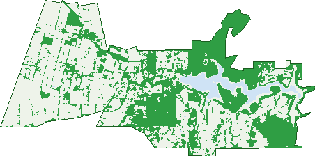
Green: 10 m cells where trees dominate, satellite 2021. Blue: water. The line is the suburb boundary.
| Canopy share, 1 m canopy height map, 2020 | 26.8% |
|---|---|
| Land with trees, 10 m satellite map, 2021 | 40.7% |
Demographics
Unemployment 3.8% · Labour-force participation 55.9%
Population by age in Harvey
| 0-4 | 177 |
|---|---|
| 5-14 | 429 |
| 15-19 | 172 |
| 20-24 | 146 |
| 25-34 | 440 |
| 35-44 | 409 |
| 45-54 | 452 |
| 55-64 | 412 |
| 65-74 | 394 |
| 75-84 | 292 |
| 85+ | 138 |
Dwelling types in Harvey
| House | 1,216 |
|---|---|
| Townhouse | 83 |
| Apartment | 0 |
| Other | 9 |
Households by weekly income in Harvey
| <$650 | 271 |
|---|---|
| $650-1,499 | 345 |
| $1,500-2,999 | 374 |
| $3,000+ | 189 |
Top ancestries in Harvey
| English | 1,251 |
|---|---|
| Australian | 1,097 |
| Italian | 527 |
| Filipino | 422 |
| Ancestry NS | 209 |
| Scottish | 206 |
Housing tenure in Harvey
| Owned | 492 |
|---|---|
| Mortgage | 383 |
| Rented | 397 |
| Other | 26 |
Cars per household in Harvey
| 0 | 72 |
|---|---|
| 1 | 432 |
| 2 | 477 |
| 3 | 192 |
| 4+ | 122 |
Commute to work in Harvey
| Car | 1,212 |
|---|---|
| Train | 0 |
| Bus | 15 |
| Tram/ferry | 0 |
| Walked | 39 |
| Bicycle | 7 |
| Home | 58 |
Top countries of birth in Harvey
| Philippines | 382 |
|---|---|
| England | 160 |
| Italy | 73 |
| New Zealand | 65 |
| China | 53 |
| Taiwan | 24 |
Languages used at home in Harvey
| Filipino | 183 |
|---|---|
| Italian | 176 |
| Tagalog | 112 |
| Mandarin | 79 |
| Korean | 10 |
| Australian Indigenous | 9 |
Birds & Wildlife Nearby
1,363 bird observations recorded near Harvey — most often seen:
- Pacific Black Duck (91)
- White-faced Heron (67)
- Australian Raven (62)
- Australian Shelduck (60)
- Red-capped Parrot (59)
- Red Wattlebird (55)
- Twenty-eight Parrot (54)
- Little Pied Cormorant (53)
- Australian Wood Duck (52)
- South-western Australian Magpie (49)
- Grey Teal (48)
- Grey Fantail (46)
- South-western Grey Fantail (45)
Show all 30 birds recorded near Harvey
- Silvereye (44)
- Eurasian Coot (42)
- Australasian Grebe (41)
- Australian Ringneck (41)
- Galah (40)
- Brown Honeyeater (37)
- Hoary-headed Grebe (36)
- Laughing Kookaburra (36)
- New Holland Honeyeater (36)
- Western Australian Raven (36)
- Australian Magpie (35)
- Western Silvereye (35)
- Willie Wagtail (35)
- Western Gerygone (34)
- Australian White Ibis (32)
- Straw-necked Ibis (32)
- Splendid Fairy-wren (30)
Sightings reported by observers, not a survey, so the counts show what people record rather than what lives here. Source: Atlas of Living Australia.
Nearby Suburbs
The closest suburbs to Harvey:
- Warawarrup (3.7 km)
- Wokalup (5 km)
- Uduc (8.9 km)
- Cookernup (9 km)
- Hoffman (9.4 km)
- Mornington (9.9 km)
- Benger (12.2 km)
- Yarloop (13.9 km)
Embed this suburb
Add this free Harvey stat card to your own site — just copy the code:
Preview:
Cite this page
Quoting these figures? Copy the credit line:
Keep an eye on Harvey
One email when this data meaningfully changes — new census figures, prices, rankings. No spam, unsubscribe anytime.
Streets
- Aachen Way (3)
- Abberton Way (7)
- Anthony Street (23)
- Ash Avenue (9)
- Baker Street (16)
- Becher Street (7)
- Boschetti Street (2)
- Bottlebrush Road (2)
- Buckby Road (31)
- Butcherbird Road (31)
- Calder Grove (2)
- Candeloro Place (7)
- Centennial Avenue (33)
- Clarke Road (1)
- Cooper Street (15)
- Eighth Street (16)
- Fielder Street (4)
- Fifth Street (17)
- Fleay Road (2)
- Fourth Street (28)
- Fryer Road (7)
- Funston Court (4)
- Galvin Street (16)
- Gerschow Avenue (19)
- Gibbs Street (15)
- Government Road (16)
- Greenfields Road (8)
- Grieves Street (12)
- Grosvenor Court (9)
- Hackett Road (19)
- Handley Road (20)
- Harding Road (1)
- Harper Street (27)
- Harvey Street (35)
- Harvey-quindanning Road (20)
- Hayward Street (33)
- Herbert Road (79)
- Hester Street (14)
- Hillside Road (10)
- Hilltop Road (1)
- Hinge Road (47)
- Hocart Road (3)
- Horizon Avenue (13)
- Hull Road (3)
- Ietto Way (25)
- Jacobs Drive (34)
- James Stirling Place (4)
- Jarrah Road (1)
- Kealy Street (13)
- Kennedy Street (10)
- Kidson Street (26)
- King Street (85)
- Knowles Street (12)
- Korijekup Avenue (33)
- Larsen Court (12)
- Lee Street (7)
- Logue Road (18)
- Lyons Way (19)
- Merriedale Crescent (32)
- Minella Road (39)
- Monterey Crescent (4)
- Newell Street (17)
- Ninth Street (19)
- Nursery Road (5)
- Palmer Street (16)
- Peet Street (38)
- Penny Lane (2)
- Pinner Street (35)
- Preston Place (6)
- Raneri Avenue (24)
- Rath Road (27)
- River Road (9)
- Roebuck Road (1)
- Rosella Loop (15)
- Roy Street (39)
- Seventh Street (15)
- Sir James Avenue (34)
- Sittella Drive (6)
- Sixth Street (13)
- Songlark Drive (2)
- South Western Highway (62)
- Spencer Street (7)
- Stanford Court (14)
- Stansfield Road (7)
- Sunnyvale Road (5)
- Sutton Street (6)
- Tenth Street (15)
- Third Street (83)
- Tomba Way (18)
- Topham Place (3)
- Trevannan Road (3)
- Triller Road (22)
- Turnbull Street (25)
- Uduc Road (199)
- Walker Road (2)
- Weir Road (35)
- Westwind Crescent (11)
- Whatman Road (3)
- Whistler Way (19)
- Willmott Crescent (33)
- Woodward Street (14)
- Wright Street (7)
- Yamballup Avenue (10)
- Young Street (80)