Harrisdale WA 6112
4,690 addresses · 220 streets
Burt Electorate › Armadale LGA › Harrisdale · 20 km from Perth
📦 Thinking of moving here? Read the Harrisdale moving guide

Living Here
Harrisdale is a suburb of Western Australia, home to about 11,667 people, with a median age of 33. The typical household earns around $2,412 a week, with median rent near $420 a week. Most homes are houses. About 79% of households own their home and 20% rent. Most workers drive to work. Common community backgrounds include English, Australian, Indian. On the ABS socio-economic scale it sits in decile 9 of 10 nationally — a relatively advantaged area.
Over time — Census 2001 → 2021
Dashed line: district figures for the Forrestdale - Harrisdale - Piara Waters statistical area (SA2), the smallest area the ABS published before 2011. Solid line: Harrisdale itself.
Getting Around & Local Services
3 Catholic churches
2 physiotherapists
3 optometrists
1 post office
1 playground
2 dog parks
2 bakeries
2 butchers
5 hardware stores
2 beauty salons
1 plumber
1 place to stay
Getting around. Train station: Ranford Road, 6 km north-west · Bus interchange: Transperth Swan Transit Depot, 8 km east · Airport: Jandakot Airport, 5.9 km north-west.
Socio-economic Standing
Deciles from 1 (lowest) to 10 (highest), against all Australian suburbs. The overall figure weighs advantage and disadvantage together; economic resources counts income and housing, and education & jobs counts qualifications and occupation. They often differ. Source: ABS SEIFA 2021.
Tree cover
🌳 Tree canopy: 21.3% share of land under canopy · satellite map, 2020
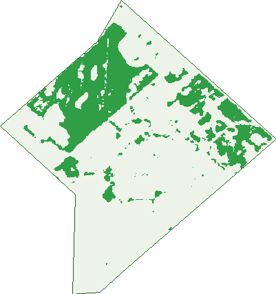
Green: 10 m cells where trees dominate, satellite 2021. Blue: water. The line is the suburb boundary.
| Canopy share, 1 m canopy height map, 2020 | 21.3% |
|---|---|
| Land with trees, 10 m satellite map, 2021 | 26.3% |
Demographics
Unemployment 4.3% · Labour-force participation 78.3%
Population by age in Harrisdale
| 0-4 | 1,114 |
|---|---|
| 5-14 | 2,271 |
| 15-19 | 646 |
| 20-24 | 509 |
| 25-34 | 1,777 |
| 35-44 | 2,721 |
| 45-54 | 1,249 |
| 55-64 | 768 |
| 65-74 | 457 |
| 75-84 | 130 |
| 85+ | 29 |
Dwelling types in Harrisdale
| House | 3,535 |
|---|---|
| Townhouse | 51 |
| Apartment | 0 |
| Other | 0 |
Households by weekly income in Harrisdale
| <$650 | 169 |
|---|---|
| $650-1,499 | 577 |
| $1,500-2,999 | 1,383 |
| $3,000+ | 1,111 |
Top ancestries in Harrisdale
| Other | 2,886 |
|---|---|
| English | 2,747 |
| Australian | 2,259 |
| Indian | 1,954 |
| Chinese | 1,281 |
| Scottish | 580 |
Housing tenure in Harrisdale
| Owned | 414 |
|---|---|
| Mortgage | 2,412 |
| Rented | 720 |
| Other | 16 |
Cars per household in Harrisdale
| 0 | 34 |
|---|---|
| 1 | 906 |
| 2 | 1,907 |
| 3 | 503 |
| 4+ | 211 |
Commute to work in Harrisdale
| Car | 4,394 |
|---|---|
| Train | 109 |
| Bus | 85 |
| Tram/ferry | 3 |
| Walked | 44 |
| Bicycle | 7 |
| Home | 432 |
Top countries of birth in Harrisdale
| India | 1,744 |
|---|---|
| England | 608 |
| Malaysia | 464 |
| South Africa | 338 |
| New Zealand | 282 |
| Philippines | 264 |
Languages used at home in Harrisdale
| Punjabi | 813 |
|---|---|
| Mandarin | 662 |
| Tamil | 427 |
| Malayalam | 421 |
| Sinhalese | 252 |
| Hindi | 251 |
Birds & Wildlife Nearby
41,867 bird observations recorded near Harrisdale — most often seen:
- Western Australian Raven (1,758)
- Red-capped Parrot (1,756)
- South-western Australian Magpie (1,691)
- Western Silvereye (1,642)
- Pacific Black Duck (1,628)
- South-western New Holland Honeyeater (1,598)
- Western Brown Honeyeater (1,593)
- Laughing Turtle-dove (1,572)
- Western Splendid Fairy-wren (1,568)
- South-western Grey Fantail (1,531)
- Southern Magpie-lark (1,489)
- Southern Willie Wagtail (1,477)
- Western Red Wattlebird (1,425)
Show all 30 birds recorded near Harrisdale
- Australian White Ibis (1,417)
- Southern Rufous Whistler (1,406)
- Southern Inland Thornbill (1,362)
- Inland Grey Butcherbird (1,355)
- South-west Western Gerygone (1,352)
- White-faced Heron (1,331)
- Twenty-eight Parrot (1,317)
- Western Yellow-rumped Thornbill (1,258)
- South-western Singing Honeyeater (1,247)
- Common Bronzewing (1,220)
- Western Striated Pardalote (1,217)
- Eastern Asian Spotted Dove (1,190)
- Mainland Black-faced Cuckoo-shrike (1,148)
- Mainland Tree Martin (1,113)
- Western Galah (1,100)
- Straw-necked Ibis (1,087)
- Australian Shelduck (1,019)
Sightings reported by observers, not a survey, so the counts show what people record rather than what lives here. Source: Atlas of Living Australia.
Nearby Suburbs
The closest suburbs to Harrisdale:
- Piara Waters (2.1 km)
- Forrestdale (3 km)
- Southern River (3.1 km)
- Canning Vale (4.5 km)
- Treeby (4.9 km)
- Champion Lakes (5.4 km)
- Huntingdale (5.4 km)
- Seville Grove (5.6 km)
Embed this suburb
Add this free Harrisdale stat card to your own site — just copy the code:
Preview:
Cite this page
Quoting these figures? Copy the credit line:
Keep an eye on Harrisdale
One email when this data meaningfully changes — new census figures, prices, rankings. No spam, unsubscribe anytime.
Streets
- Abercrombie Entrance (38)
- Alamo Link (13)
- Alcaston Road (10)
- Amanita Avenue (24)
- Anca Way (5)
- Annandale Way (17)
- Archer Brace (7)
- Ardella Way (23)
- Argo Way (6)
- Arion Avenue (8)
- Arkose Crescent (13)
- Ascot Lane (4)
- Axia Place (2)
- Baillon Pass (15)
- Balannup Road (11)
- Baldessin Avenue (15)
- Balmain Loop (17)
- Bambili Way (19)
- Barossa Loop (27)
- Basalt Road (14)
- Baystone Parade (17)
- Beltana Street (17)
- Benalla Drive (18)
- Binnia Mews (19)
- Bloomsbury Way (32)
- Bonvue Road (31)
- Brummels Vista (56)
- Brunonia Terrace (43)
- Calidris Crescent (14)
- Camballin Street (40)
- Canterbury Trail (33)
- Carnaby Way (16)
- Casula Place (4)
- Celia Way (19)
- Chariot Turn (35)
- Chatham Way (26)
- Cheltenham Approach (16)
- Chiara Avenue (12)
- Collared Street (35)
- Colville Street (1)
- Conical Way (5)
- Copley Link (1)
- Corella Approach (7)
- Corymbia Way (31)
- Counihan Bend (15)
- Cowes Street (27)
- Crested Turn (25)
- Crimson Way (19)
- Crossley Way (6)
- Cyperus Crescent (30)
- Darter Way (4)
- Dealey Elbow (15)
- Delmar Avenue (12)
- Derby Lane (4)
- Diamond Way (12)
- Dovedale Street (99)
- Drill Way (2)
- Dunmore Crescent (46)
- Duomo Way (16)
- Easthope Link (1)
- Egret Lane (2)
- Eiffel Lane (8)
- Elegant Approach (16)
- Emanuele Bend (11)
- Erlon Way (13)
- Evandale Way (20)
- Exchange Avenue (53)
- Fairhaven Avenue (19)
- Falkner Road (20)
- Fernhill Promenade (33)
- Ferry Court (2)
- Flametree Boulevard (54)
- Floradale Road (21)
- Foundry Turn (24)
- Gabyon Street (15)
- Gallinago Corner (32)
- Garinga Road (16)
- Gleeson Way (13)
- Glenora Way (22)
- Global Avenue (22)
- Goldfinch Bend (38)
- Gracefield Boulevard (137)
- Granite Road (9)
- Greenlink Boulevard (55)
- Greenshank Road (28)
- Gregson Street (24)
- Gypsum Avenue (27)
- Hamelin Loop (34)
- Harrisdale Drive (55)
- Hatch Court (12)
- Hazeldene Drive (38)
- Hellenic Parkway (6)
- Heronwood Glade (28)
- Hewitt Link (5)
- Homebush Way (13)
- Horsham Crescent (28)
- Hurbon Way (6)
- Indee Way (6)
- Ingot Lane (5)
- Jalna Way (10)
- Jimba Way (7)
- Kaliman Bend (15)
- Karinga Way (24)
- Keane Road (78)
- Kersley Loop (23)
- Korong Way (18)
- Kudos Circuit (46)
- Kulbardi Way (18)
- Lafayette Avenue (45)
- Lamboo Road (21)
- Lapwing Approach (14)
- Lauraine Drive (17)
- Laverton Crescent (15)
- Leopold Road (16)
- Lialis Lane (5)
- Liberation Street (31)
- Liscombe Crescent (23)
- Lorista Lane (2)
- Macdougal Way (24)
- Malop Link (5)
- Manberry Crescent (22)
- Mayor Street (49)
- Meka Way (12)
- Mildura Way (14)
- Mingara Avenue (15)
- Minton Bend (18)
- Montsalvat Grange (15)
- Monument Street (25)
- Morelia Crescent (8)
- Morlup Road (20)
- Mossgreen Link (6)
- Nambi Way (6)
- Newquay Street (8)
- Nicklup Street (19)
- Nikon Road (28)
- Nisden View (13)
- Nobilis Street (16)
- Northcote Street (11)
- Northerly Drive (47)
- Oakbella Parade (33)
- Oakleigh Pass (36)
- Ogilvie Way (25)
- Olinda Street (13)
- Olsen Bend (21)
- Ornatus Road (5)
- Pallid Street (8)
- Papyrus Loop (26)
- Pardalote Road (25)
- Peaceful Vista (22)
- Peregrine Link (5)
- Pershing Link (39)
- Petersham Street (18)
- Pinnacles Street (16)
- Portsmouth Way (32)
- Preissiana Way (13)
- Pricklybark Street (22)
- Pyramid Road (43)
- Quenda Road (4)
- Randwick Bend (23)
- Ranford Road (11)
- Raven Way (16)
- Reilly Road (2)
- Rockefeller Way (51)
- Rockvale Crescent (40)
- Rufous Lane (5)
- Sacred Glade (10)
- Saddle Lane (14)
- Sandpiper Street (10)
- Sandstone Promenade (21)
- Sapium Street (5)
- Schwartz Avenue (11)
- Sheaf Way (7)
- Shelduck Bend (30)
- Shepherd Court (12)
- Shepherd Street (12)
- Silvershot Avenue (54)
- Skeet Road (64)
- Slate Way (12)
- Soho Lane (4)
- Solander Street (18)
- Songbird Link (4)
- Sotheby Drive (8)
- Splendid Gardens (17)
- Spoonbill Street (10)
- Stanley Street (17)
- Steffan Loop (53)
- Stills Avenue (16)
- Stilt Lane (5)
- Tenterfield Green (14)
- Tettigoni Parade (1)
- The Grandstand (11)
- Thistle Way (23)
- Times Street (17)
- Tipuana Terrace (38)
- Tolarno Bend (29)
- Tompkins Way (28)
- Torget Lane (7)
- Travertine Street (19)
- Tringa Crescent (9)
- Turnstone Link (17)
- Turtledove Road (25)
- Victory Street (42)
- Vondel Lane (5)
- Walgun Lane (7)
- Warbler Pass (9)
- Warton Road (2)
- Welcome Meander (42)
- Whimbrel Way (13)
- Whitehorse Drive (36)
- Whitmore Loop (44)
- Willoughby Ramble (27)
- Windstorm Road (20)
- Wing Lane (3)
- Woodleigh Way (14)
- Wright Road (119)
- Wyoming Loop (69)
- Yalleen Street (26)
- Yellowwood Avenue (51)
- Yering Lane (20)
- Zeehan Lane (7)