Gwelup WA 6018
2,354 addresses · 106 streets
Moore Electorate › Stirling LGA › Gwelup · 11 km from Perth
📦 Thinking of moving here? Read the Gwelup moving guide

Living Here
Gwelup is a suburb of Western Australia, home to about 5,391 people, with a median age of 42. The typical household earns around $2,658 a week, with median rent near $600 a week. Most homes are houses. About 85% of households own their home and 9% rent. Most workers drive to work. Common community backgrounds include English, Australian, Scottish. On the ABS socio-economic scale it sits in decile 10 of 10 nationally — a relatively advantaged area.
Over time — Census 2001 → 2021
Dashed line: district figures for the Karrinyup - Gwelup - Carine statistical area (SA2), the smallest area the ABS published before 2011. Solid line: Gwelup itself.
Getting Around & Local Services
1 pharmacy
2 doctors & medical clinics
1 dentist
1 childcare centre
3 post offices
2 bakeries
1 butcher
2 plumbers
1 carpenter
Getting around. Train station: Stirling, 2.8 km south · Bus interchange: Mirrabooka Bus Station, 6 km east · Ferry wharf: Rottnest Ferry, 7.5 km north-west · Airport: Perth Airport, 17.7 km south-east.
Socio-economic Standing
Deciles from 1 (lowest) to 10 (highest), against all Australian suburbs. The overall figure weighs advantage and disadvantage together; economic resources counts income and housing, and education & jobs counts qualifications and occupation. They often differ. Source: ABS SEIFA 2021.
Tree cover
🌳 Tree canopy: 16.8% share of land under canopy · satellite map, 2020
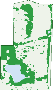
Green: 10 m cells where trees dominate, satellite 2021. Blue: water. The line is the suburb boundary.
| Canopy share, 1 m canopy height map, 2020 | 16.8% |
|---|---|
| Land with trees, 10 m satellite map, 2021 | 29.3% |
Demographics
Unemployment 2.7% · Labour-force participation 63.4%
Population by age in Gwelup
| 0-4 | 360 |
|---|---|
| 5-14 | 779 |
| 15-19 | 310 |
| 20-24 | 221 |
| 25-34 | 407 |
| 35-44 | 787 |
| 45-54 | 786 |
| 55-64 | 543 |
| 65-74 | 498 |
| 75-84 | 411 |
| 85+ | 292 |
Dwelling types in Gwelup
| House | 1,542 |
|---|---|
| Townhouse | 161 |
| Apartment | 55 |
| Other | 52 |
Households by weekly income in Gwelup
| <$650 | 227 |
|---|---|
| $650-1,499 | 317 |
| $1,500-2,999 | 384 |
| $3,000+ | 739 |
Top ancestries in Gwelup
| English | 2,184 |
|---|---|
| Australian | 1,728 |
| Scottish | 541 |
| Irish | 531 |
| Italian | 527 |
| Other | 506 |
Housing tenure in Gwelup
| Owned | 720 |
|---|---|
| Mortgage | 786 |
| Rented | 165 |
| Other | 111 |
Cars per household in Gwelup
| 0 | 49 |
|---|---|
| 1 | 489 |
| 2 | 898 |
| 3 | 239 |
| 4+ | 119 |
Commute to work in Gwelup
| Car | 1,706 |
|---|---|
| Train | 65 |
| Bus | 16 |
| Tram/ferry | 0 |
| Walked | 21 |
| Bicycle | 27 |
| Home | 286 |
Top countries of birth in Gwelup
| England | 379 |
|---|---|
| South Africa | 102 |
| New Zealand | 101 |
| China | 76 |
| Scotland | 65 |
| Italy | 61 |
Languages used at home in Gwelup
| Mandarin | 123 |
|---|---|
| Italian | 93 |
| Cantonese | 40 |
| Portuguese | 33 |
| Gujarati | 32 |
| Persian | 27 |
Birds & Wildlife Nearby
63,638 bird observations recorded near Gwelup — most often seen:
- Blue-billed Duck (5,115)
- Australian Raven (3,197)
- Rainbow Lorikeet (3,124)
- Willie Wagtail (3,001)
- Glossy Ibis (2,929)
- Red Wattlebird (2,873)
- Short-billed Black-cockatoo (2,704)
- South-western Australian Magpie (2,631)
- Australian White Ibis (2,598)
- Singing Honeyeater (2,507)
- Eurasian Coot (2,211)
- Pacific Black Duck (2,202)
- Laughing Turtle-dove (2,160)
Show all 30 birds recorded near Gwelup
- Galah (1,966)
- Dusky Moorhen (1,802)
- Little Corella (1,801)
- Australasian Grebe (1,763)
- Brown Honeyeater (1,723)
- Magpie-lark (1,619)
- New Holland Honeyeater (1,567)
- Black Swan (1,566)
- Western Australian Raven (1,533)
- South-western Singing Honeyeater (1,476)
- Australian Magpie (1,473)
- Eastern Rainbow Lorikeet (1,466)
- Western Red Wattlebird (1,452)
- Grey Teal (1,344)
- Australian Shelduck (1,343)
- Australasian Purple Swamphen (1,255)
- Southern Willie Wagtail (1,237)
Sightings reported by observers, not a survey, so the counts show what people record rather than what lives here. Source: Atlas of Living Australia.
Nearby Suburbs
The closest suburbs to Gwelup:
Embed this suburb
Add this free Gwelup stat card to your own site — just copy the code:
Preview:
Cite this page
Quoting these figures? Copy the credit line:
Keep an eye on Gwelup
One email when this data meaningfully changes — new census figures, prices, rankings. No spam, unsubscribe anytime.
Streets
- Aachen Crescent (46)
- Abdale Street (16)
- Agnew Loop (38)
- Allanson Retreat (28)
- Arbuckle Place (6)
- Arrino Close (9)
- Balcatta Road (17)
- Bernardini Court (6)
- Bestry Entrance (5)
- Bindoon Close (15)
- Blackbird Avenue (41)
- Brushfield Way (18)
- Bullrush Street (10)
- Calautti Court (23)
- Careniup Avenue (53)
- Carslake Grove (13)
- Caspian Court (6)
- Chieti Place (8)
- Chivrell Rise (10)
- Cinnamon Road (24)
- Columbite Road (7)
- Coucal Street (21)
- Crake Fairway (4)
- D'ercole Court (9)
- Dardanup Green (18)
- Dunlin Way (24)
- Erindale Road (3)
- Exmouth Vista (24)
- Eyrean Way (12)
- Fantail Avenue (19)
- Feldspar Parade (25)
- Frogmouth Terrace (10)
- Gardon Rise (52)
- Grassbird Parade (9)
- Gribble Road (67)
- Grimwood Avenue (21)
- Hanlin Court (7)
- Hoyne View (9)
- Huntriss Road (182)
- Invicta Place (7)
- Jacana Circle (40)
- Jodrell Road (34)
- Karrinyup Road (47)
- Kellett Close (14)
- Kojonup Close (16)
- Kulja Mews (16)
- Lagonda Drive (15)
- Lake Edge Court (14)
- Lakewaters View (9)
- Laxton Way (13)
- Lazarov Retreat (8)
- Lehmans Mews (6)
- Liddington Court (4)
- Loncar Rise (14)
- Lucev Place (5)
- Ludgate Way (27)
- Lyndale Street (21)
- Mallee Way (29)
- Manjimup Place (19)
- March Street (17)
- Mellersh Court (11)
- Mews Entrance (4)
- Milicich Cove (6)
- Mollison Gardens (11)
- Nankeen Way (17)
- Nolan Crescent (25)
- North Beach Road (146)
- O'ryan Close (10)
- Old Balcatta Road (26)
- Pascoe Street (1)
- Pomarine Drive (36)
- Porongurup Way (12)
- Porter Street (85)
- Raffan View (8)
- Rainbow Way (19)
- Ravensthorpe Way (7)
- Rush Cove (6)
- Salvin Road (5)
- Sarus Rise (27)
- Segrave Street (147)
- Settlers Circle (20)
- Skender Place (7)
- Snipe Court (5)
- Sollya Close (8)
- Speight Rise (10)
- Stipa Court (4)
- Sunbird Way (12)
- Swiftlet Way (31)
- Talma Place (6)
- Teale Court (9)
- Tektite Way (8)
- The Rise (37)
- Tristan Road (11)
- Turnix Road (21)
- Udall Place (9)
- Ufton Street (31)
- Valance Way (34)
- Waldemar Street (29)
- Wanborough Close (5)
- Wanstead Street (19)
- Warrener Gardens (29)
- Water Crest Gardens (27)
- Waterside Crescent (24)
- Willow Bank Entrance (28)
- Wiltshire Gate (10)
- Wishart Street (21)