Fremantle WA 6160
8,530 addresses · 120 streets
Fremantle Electorate › Fremantle LGA › Fremantle · 15 km from Perth
📦 Thinking of moving here? Read the Fremantle moving guide

Living Here
A historic port city at the mouth of the Swan River, Fremantle is known for its heritage architecture, markets and arts scene. Households average 2.0 people and the median age is 41. Median household income is $1,822 a week, with rent around $380.
Fremantle is a suburb of Western Australia, home to about 9,251 people, with a median age of 41. The typical household earns around $1,822 a week, with median rent near $380 a week. Most homes are houses. About 56% of households own their home and 42% rent. Most workers drive to work. Common community backgrounds include English, Australian, Irish. On the ABS socio-economic scale it sits in decile 9 of 10 nationally — a relatively advantaged area.
Over time — Census 2001 → 2021
Dashed line: district figures for the Fremantle statistical area (SA2), the smallest area the ABS published before 2011. Solid line: Fremantle itself.
Getting Around & Local Services
1 playground
1 dog park
Getting around. Train station: Fremantle, 950 m west · Bus interchange: Fremantle Station, 900 m west · Ferry wharf: Fremantle Passenger Terminal, 1000 m north-west · Airport: Jandakot Airport, 12.4 km east.
Socio-economic Standing
Deciles from 1 (lowest) to 10 (highest), against all Australian suburbs. The overall figure weighs advantage and disadvantage together; economic resources counts income and housing, and education & jobs counts qualifications and occupation. They often differ. Source: ABS SEIFA 2021.
Tree cover
🌳 Tree canopy: 11.1% share of land under canopy · satellite map, 2020
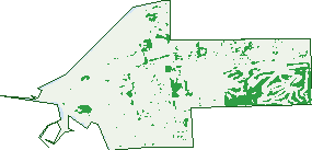
Green: 10 m cells where trees dominate, satellite 2021. Blue: water. The line is the suburb boundary.
| Canopy share, 1 m canopy height map, 2020 | 11.1% |
|---|---|
| Land with trees, 10 m satellite map, 2021 | 10.0% |
Demographics
Unemployment 5.1% · Labour-force participation 64.4%
Population by age in Fremantle
| 0-4 | 349 |
|---|---|
| 5-14 | 637 |
| 15-19 | 367 |
| 20-24 | 633 |
| 25-34 | 1,690 |
| 35-44 | 1,293 |
| 45-54 | 1,293 |
| 55-64 | 1,278 |
| 65-74 | 1,040 |
| 75-84 | 499 |
| 85+ | 166 |
Dwelling types in Fremantle
| House | 1,622 |
|---|---|
| Townhouse | 1,306 |
| Apartment | 1,116 |
| Other | 12 |
Households by weekly income in Fremantle
| <$650 | 736 |
|---|---|
| $650-1,499 | 879 |
| $1,500-2,999 | 1,065 |
| $3,000+ | 1,083 |
Top ancestries in Fremantle
| English | 3,895 |
|---|---|
| Australian | 2,442 |
| Irish | 1,385 |
| Scottish | 1,151 |
| Other | 976 |
| Ancestry NS | 785 |
Housing tenure in Fremantle
| Owned | 1,153 |
|---|---|
| Mortgage | 1,111 |
| Rented | 1,689 |
| Other | 59 |
Cars per household in Fremantle
| 0 | 477 |
|---|---|
| 1 | 1,898 |
| 2 | 1,237 |
| 3 | 278 |
| 4+ | 122 |
Commute to work in Fremantle
| Car | 2,629 |
|---|---|
| Train | 188 |
| Bus | 197 |
| Tram/ferry | 0 |
| Walked | 376 |
| Bicycle | 141 |
| Home | 605 |
Top countries of birth in Fremantle
| England | 814 |
|---|---|
| New Zealand | 204 |
| Italy | 176 |
| United States | 123 |
| Ireland | 114 |
| Scotland | 111 |
Languages used at home in Fremantle
| Italian | 264 |
|---|---|
| French | 121 |
| Spanish | 100 |
| German | 91 |
| Croatian | 47 |
| Portuguese | 44 |
Birds & Wildlife Nearby
29,791 bird observations recorded near Fremantle — most often seen:
- Silver Gull (2,042)
- Laughing Turtle-dove (1,630)
- Willie Wagtail (1,560)
- Australian Raven (1,463)
- Singing Honeyeater (1,355)
- Red Wattlebird (1,322)
- Rainbow Lorikeet (1,301)
- Pied Cormorant (1,239)
- Australian Magpie (1,172)
- Welcome Swallow (1,087)
- South-western Australian Magpie (1,008)
- Western Red Wattlebird (984)
- South-western Singing Honeyeater (958)
Show all 30 birds recorded near Fremantle
- Eastern Rainbow Lorikeet (921)
- Western Australian Raven (903)
- Magpie-lark (899)
- Pacific Black Duck (859)
- Galah (849)
- Southern Willie Wagtail (807)
- Giinbaywarraymal (799)
- Rock Dove (799)
- Little Pied Cormorant (735)
- Western Brown Honeyeater (714)
- Brown Honeyeater (712)
- Eastern Asian Spotted Dove (672)
- Spotted Turtle-dove (666)
- New Holland Honeyeater (664)
- Little Corella (573)
- South-western New Holland Honeyeater (569)
- Silvereye (529)
Sightings reported by observers, not a survey, so the counts show what people record rather than what lives here. Source: Atlas of Living Australia.
Nearby Suburbs
The closest suburbs to Fremantle:
- White Gum Valley (1.7 km)
- South Fremantle (1.9 km)
- East Fremantle (1.9 km)
- Beaconsfield (2.1 km)
- North Fremantle (2.5 km)
- Palmyra (3.1 km)
- Hilton (3.3 km)
- O'connor (3.6 km)
Embed this suburb
Add this free Fremantle stat card to your own site — just copy the code:
Preview:
Cite this page
Quoting these figures? Copy the credit line:
Keep an eye on Fremantle
One email when this data meaningfully changes — new census figures, prices, rankings. No spam, unsubscribe anytime.
Streets
- Adelaide Street (320)
- Alma Street (23)
- Ameling Rise (6)
- Amherst Street (69)
- Arthur Head (1)
- Arundel Street (112)
- Ashburton Terrace (37)
- Attfield Street (81)
- Baker Street (7)
- Bannister Street (161)
- Barnett Street (19)
- Bateman Street (5)
- Beach Street (304)
- Bellevue Terrace (93)
- Blinco Street (135)
- Bolton Place (31)
- Brennan Street (5)
- Burt Street (87)
- Canning Highway (3)
- Cantonment Street (187)
- Captains Lane (8)
- Carnac Street (43)
- Carrington Street (17)
- Chalmers Street (59)
- Chudleigh Street (18)
- Cliff Street (52)
- Collie Street (46)
- Coode Street (50)
- Crandon Street (11)
- Croke Lane (3)
- Croke Street (2)
- Dorothy Street (26)
- Douglas Street (12)
- East Street (100)
- Edmund Street (81)
- Elder Place (30)
- Ellen Street (86)
- Essex Street (46)
- Euphrasie Court (10)
- Finnerty Street (8)
- Fleet Street (7)
- Forrest Street (361)
- Fothergill Street (31)
- Friend Street (20)
- Girton Lane (6)
- Goldsbrough Street (1)
- Grey Street (42)
- Hampton Road (171)
- Henderson Street (36)
- Henry Street (135)
- Henville Street (8)
- High Street (596)
- High Street Mall (95)
- Holdsworth Street (46)
- Holland Street (398)
- Howard Street (40)
- Hudson Mews (10)
- James Street (43)
- Josephson Street (12)
- Kellow Place (15)
- Knutsford Street (245)
- Leake Street (21)
- Limerick Way (4)
- Little High Street (20)
- Little Howard Street (26)
- Loukes Street (7)
- Malcolm Street (59)
- Manning Street (17)
- Marine Terrace (114)
- Market Street (106)
- Marmion Street (179)
- Mcatee Court (47)
- Mews Road (65)
- Molfetta Quays (13)
- Montreal Street (53)
- Mouat Street (42)
- Mrs Trivett Place (5)
- Nairn Street (29)
- Newman Court (25)
- Norfolk Street (103)
- Norman Street (47)
- Onslow Street (23)
- Ord Street (92)
- Pakenham Street (194)
- Parry Street (81)
- Peter Hughes Drive (1)
- Phillimore Street (59)
- Point Street (25)
- Price Street (43)
- Pulford Lane (10)
- Quarry Street (144)
- Queen Street (93)
- Queen Victoria Street (453)
- Robinson Street (16)
- Rochfort Way (24)
- Russell Street (50)
- Samson Street (41)
- Short Street (11)
- Shuffrey Street (11)
- Skinner Street (4)
- Slip Street (2)
- Solomon Street (156)
- South Street (117)
- South Terrace (260)
- Stack Street (40)
- Stevens Street (99)
- Stirling Street (37)
- Suffolk Street (53)
- Swanbourne Street (127)
- Terrazzo Lane (29)
- The Terrace (13)
- Tuckfield Street (73)
- Vale Street (33)
- Wardan Lane (1)
- Watkins Street (32)
- Westgate Mall (13)
- Wilkinson Street (13)
- William Street (128)
- Wood Street (73)
- Wray Avenue (162)