Exmouth WA 6707
2,286 addresses · 105 streets
Durack Electorate › Exmouth LGA › Exmouth · 1127 km from Perth
📦 Thinking of moving here? Read the Exmouth moving guide

Living Here
Exmouth is a suburb of Western Australia, home to about 2,806 people, with a median age of 36. The typical household earns around $2,029 a week, with median rent near $340 a week. Most homes are houses. About 55% of households own their home and 43% rent. Most workers drive to work. Common community backgrounds include Australian, English, Scottish. On the ABS socio-economic scale it sits in decile 6 of 10 nationally — a mid-range area.
Over time — Census 2001 → 2021
Dashed line: district figures for the Exmouth statistical area (SA2), the smallest area the ABS published before 2011. Solid line: Exmouth itself.
Getting Around & Local Services
1 school
3 supermarkets
1 beach
1 pharmacy
2 physiotherapists
1 hospital
1 childcare centre
1 library
1 post office
3 service stations
2 gyms & sports centres
1 golf club
1 bakery
2 hairdressers
Getting around. Ferry wharf: Cruise Ship Tender Dock, 2.5 km south-east · Airport: Exmouth Airport, 11.7 km south.
Socio-economic Standing
Deciles from 1 (lowest) to 10 (highest), against all Australian suburbs. The overall figure weighs advantage and disadvantage together; economic resources counts income and housing, and education & jobs counts qualifications and occupation. They often differ. Source: ABS SEIFA 2021.
Tree cover
🌳 Tree canopy: 0.2% share of land under canopy · satellite map, 2020
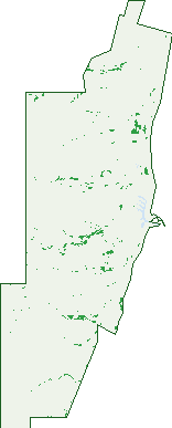
Green: 10 m cells where trees dominate, satellite 2021. Blue: water. The line is the suburb boundary.
| Canopy share, 1 m canopy height map, 2020 | 0.2% |
|---|---|
| Land with trees, 10 m satellite map, 2021 | 1.7% |
Demographics
Unemployment 2.5% · Labour-force participation 71.4%
Population by age in Exmouth
| 0-4 | 173 |
|---|---|
| 5-14 | 338 |
| 15-19 | 135 |
| 20-24 | 164 |
| 25-34 | 500 |
| 35-44 | 453 |
| 45-54 | 384 |
| 55-64 | 329 |
| 65-74 | 219 |
| 75-84 | 96 |
| 85+ | 17 |
Dwelling types in Exmouth
| House | 826 |
|---|---|
| Townhouse | 25 |
| Apartment | 50 |
| Other | 87 |
Households by weekly income in Exmouth
| <$650 | 106 |
|---|---|
| $650-1,499 | 184 |
| $1,500-2,999 | 313 |
| $3,000+ | 216 |
Top ancestries in Exmouth
| Australian | 1,182 |
|---|---|
| English | 1,088 |
| Scottish | 286 |
| Ancestry NS | 262 |
| Irish | 232 |
| Other | 193 |
Housing tenure in Exmouth
| Owned | 212 |
|---|---|
| Mortgage | 324 |
| Rented | 418 |
| Other | 24 |
Cars per household in Exmouth
| 0 | 16 |
|---|---|
| 1 | 299 |
| 2 | 382 |
| 3 | 155 |
| 4+ | 122 |
Commute to work in Exmouth
| Car | 998 |
|---|---|
| Train | 0 |
| Bus | 17 |
| Tram/ferry | 0 |
| Walked | 126 |
| Bicycle | 91 |
| Home | 102 |
Top countries of birth in Exmouth
| England | 120 |
|---|---|
| New Zealand | 68 |
| United States | 47 |
| Philippines | 33 |
| Germany | 28 |
| Scotland | 19 |
Languages used at home in Exmouth
| Spanish | 38 |
|---|---|
| German | 20 |
| Tagalog | 15 |
| Mandarin | 14 |
| Italian | 14 |
| French | 10 |
Birds & Wildlife Nearby
8,400 bird observations recorded near Exmouth — most often seen:
- Crested Pigeon (647)
- Yellow-throated Miner (569)
- Little Corella (566)
- Silver Gull (502)
- Singing Honeyeater (429)
- Welcome Swallow (409)
- Magpie-lark (400)
- White-plumed Honeyeater (370)
- Rainbow Bee-eater (336)
- Zebra Finch (318)
- Galah (304)
- Emu (283)
- Whistling Kite (274)
Show all 30 birds recorded near Exmouth
- Grey Teal (264)
- Pied Butcherbird (262)
- Tree Martin (230)
- Brown Honeyeater (221)
- Banded Lapwing (214)
- Masked Lapwing (212)
- Peaceful Dove (197)
- Straw-necked Ibis (189)
- Pacific Black Duck (178)
- Torresian Crow (173)
- Rufous Songlark (145)
- Australian Pelican (131)
- Australian Ringneck (124)
- Purple-backed Fairy-wren (124)
- Black-faced Cuckoo-shrike (114)
- Black-shouldered Kite (108)
- Western Bowerbird (107)
Sightings reported by observers, not a survey, so the counts show what people record rather than what lives here. Source: Atlas of Living Australia.
Nearby Suburbs
The closest suburbs to Exmouth:
- North West Cape (8.1 km)
- Learmonth (21 km)
Embed this suburb
Add this free Exmouth stat card to your own site — just copy the code:
Preview:
Cite this page
Quoting these figures? Copy the credit line:
Keep an eye on Exmouth
One email when this data meaningfully changes — new census figures, prices, rankings. No spam, unsubscribe anytime.
Streets
- Bennett Street (14)
- Bluefin Cove (44)
- Bonefish Street (1)
- Broad Street (4)
- Cameron Street (9)
- Campbell Way (17)
- Carey Street (13)
- Carpenter Street (26)
- Carr Way (27)
- Carter Road (8)
- Catalina Close (10)
- Christie Street (43)
- Cobia Close (39)
- Cooyou Close (31)
- Coral Way (12)
- Corella Court (35)
- Craft Street (6)
- Crevalle Way (10)
- Davidson Street (21)
- Dugong Close (60)
- Eurayle Street (14)
- Falls Street (20)
- Farley Street (10)
- Fitzhardinge Street (36)
- Fletcher Street (10)
- Fyfe Street (26)
- Gnandaroo Road (5)
- Gnulli Court (29)
- Gooley Street (7)
- Grayling Way (11)
- Grenadier Street (17)
- Grey Street (3)
- Griffin Way (7)
- Griffiths Way (14)
- Hall Street (23)
- Heron Way (11)
- Horwood Quays (3)
- Huston Street (5)
- Inggarda Lane (18)
- Ingleton Street (23)
- Jones Place (7)
- Keillor Place (4)
- Kennedy Street (48)
- Kestrel Place (34)
- King Place (24)
- Klein Street (2)
- Koolinda Way (22)
- Krait Street (20)
- Learmonth Street (87)
- Lefroy Street (63)
- Lockwood Street (27)
- Lyon Street (15)
- Madaffari Drive (84)
- Maidstone Crescent (119)
- Maley Street (25)
- Marlin Terrace (2)
- Marsh Street (3)
- Mcleod Street (7)
- Mortiss Street (9)
- Murat Road (211)
- Neale Cove (1)
- Nimitz Street (61)
- Ningaloo Street (21)
- Osprey Way (26)
- Page Street (16)
- Patterson Way (15)
- Payne Street (11)
- Pelias Street (28)
- Pellew Street (55)
- Potshot Street (8)
- Preston Street (15)
- Redfin Court (6)
- Reid Street (1)
- Reymond Street (1)
- Riggs Street (1)
- Rimau Way (4)
- Ross Street (11)
- Rule Street (3)
- Sailfish Link (4)
- Salmon Loop (35)
- Sargent Street (32)
- Sargo Court (4)
- Saury Place (4)
- Schmidt Way (16)
- Sculpin Court (6)
- Searaven Crescent (26)
- Seawolf Place (5)
- Skipjack Circle (35)
- Snapper Loop (56)
- Stefano Way (2)
- Stewart Street (17)
- Stokes-hughes Street (71)
- Tambor Drive (49)
- Tautog Street (19)
- Thew Street (6)
- Tonge Place (8)
- Trout Place (6)
- Truscott Crescent (6)
- Turnor Place (7)
- Wahoo Close (2)
- Walters Way (11)
- Warne Street (4)
- Warren Way (13)
- Welch Street (19)
- Willersdorf Road (4)