Cowaramup WA 6284
1,689 addresses · 123 streets
Forrest Electorate › Augusta Margaret River LGA › Cowaramup · 223 km from Perth
📦 Thinking of moving here? Read the Cowaramup moving guide

Living Here
Cowaramup is a suburb of Western Australia, home to about 2,482 people, with a median age of 39. The typical household earns around $1,925 a week, with median rent near $390 a week. Most homes are houses. About 81% of households own their home and 18% rent. Most workers drive to work. Common community backgrounds include English, Australian, Ancestry NS. On the ABS socio-economic scale it sits in decile 8 of 10 nationally — a relatively advantaged area.
Over time — Census 2001 → 2021
Dashed line: district figures for the Augusta statistical area (SA2), the smallest area the ABS published before 2011. Solid line: Cowaramup itself.
Getting Around & Local Services
1 school
4 cafés & restaurants
1 pharmacy
1 hospital
1 post office
2 service stations
1 gym
1 bakery
1 butcher
1 hairdresser
1 mechanic
Getting around. Airport: Margaret River Aerodrome, 8.7 km south.
Socio-economic Standing
Deciles from 1 (lowest) to 10 (highest), against all Australian suburbs. The overall figure weighs advantage and disadvantage together; economic resources counts income and housing, and education & jobs counts qualifications and occupation. They often differ. Source: ABS SEIFA 2021.
Tree cover
🌳 Tree canopy: 18.1% share of land under canopy · satellite map, 2020
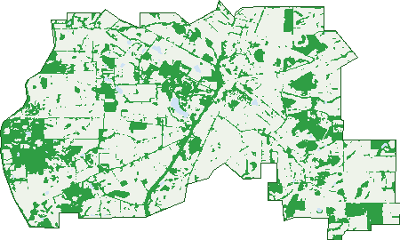
Green: 10 m cells where trees dominate, satellite 2021. Blue: water. The line is the suburb boundary.
| Canopy share, 1 m canopy height map, 2020 | 18.1% |
|---|---|
| Land with trees, 10 m satellite map, 2021 | 28.3% |
Demographics
Unemployment 2.4% · Labour-force participation 69.7%
Population by age in Cowaramup
| 0-4 | 177 |
|---|---|
| 5-14 | 477 |
| 15-19 | 110 |
| 20-24 | 54 |
| 25-34 | 217 |
| 35-44 | 494 |
| 45-54 | 376 |
| 55-64 | 288 |
| 65-74 | 185 |
| 75-84 | 74 |
| 85+ | 23 |
Dwelling types in Cowaramup
| House | 741 |
|---|---|
| Townhouse | 16 |
| Apartment | 0 |
| Other | 0 |
Households by weekly income in Cowaramup
| <$650 | 73 |
|---|---|
| $650-1,499 | 187 |
| $1,500-2,999 | 279 |
| $3,000+ | 152 |
Top ancestries in Cowaramup
| English | 1,127 |
|---|---|
| Australian | 1,028 |
| Ancestry NS | 272 |
| Irish | 264 |
| Scottish | 241 |
| Other | 157 |
Housing tenure in Cowaramup
| Owned | 213 |
|---|---|
| Mortgage | 395 |
| Rented | 134 |
| Other | 13 |
Cars per household in Cowaramup
| 0 | 11 |
|---|---|
| 1 | 181 |
| 2 | 375 |
| 3 | 139 |
| 4+ | 59 |
Commute to work in Cowaramup
| Car | 750 |
|---|---|
| Train | 0 |
| Bus | 20 |
| Tram/ferry | 0 |
| Walked | 37 |
| Bicycle | 9 |
| Home | 160 |
Top countries of birth in Cowaramup
| England | 170 |
|---|---|
| New Zealand | 65 |
| United States | 23 |
| Germany | 20 |
| South Africa | 17 |
| Canada | 14 |
Languages used at home in Cowaramup
| German | 28 |
|---|---|
| Italian | 15 |
| French | 13 |
| Korean | 8 |
| Spanish | 8 |
| Vietnamese | 7 |
Birds & Wildlife Nearby
793 bird observations recorded near Cowaramup — most often seen:
- Australian Magpie (58)
- Red Wattlebird (48)
- New Holland Honeyeater (44)
- Australian Ringneck (41)
- Australian Raven (36)
- Grey Fantail (36)
- Australian Shelduck (34)
- Laughing Kookaburra (32)
- Silvereye (32)
- Twenty-eight Parrot (28)
- Pacific Black Duck (27)
- Australian White Ibis (26)
- Brown Honeyeater (26)
Show all 30 birds recorded near Cowaramup
- Galah (23)
- Red-winged Fairy-wren (23)
- Australian Wood Duck (22)
- Common Bronzewing (22)
- White-faced Heron (22)
- Red-rumped Tit (21)
- Willie Wagtail (21)
- Grey Butcherbird (20)
- South-western Spotted Scrubwren (19)
- Straw-necked Ibis (19)
- Splendid Fairy-wren (18)
- Eurasian Coot (16)
- Gilbert's Honeyeater (16)
- Golden Whistler (16)
- Little Corella (16)
- Little Pied Cormorant (16)
- Regent Parrot (15)
Sightings reported by observers, not a survey, so the counts show what people record rather than what lives here. Source: Atlas of Living Australia.
Nearby Suburbs
The closest suburbs to Cowaramup:
Embed this suburb
Add this free Cowaramup stat card to your own site — just copy the code:
Preview:
Cite this page
Quoting these figures? Copy the credit line:
Keep an eye on Cowaramup
One email when this data meaningfully changes — new census figures, prices, rankings. No spam, unsubscribe anytime.
Streets
- Abberton Lane (6)
- Ablett Road (4)
- Acacia Court (7)
- Armstrong Road (5)
- Barnard Street (5)
- Barnett Grove (1)
- Bird Wood Lane (15)
- Birdhaven Entrance (7)
- Blaikie Road (3)
- Blond Street (4)
- Blue Gum Place (7)
- Blue Wren Place (2)
- Bottrell Street (8)
- Bottrill Street (8)
- Boundary Road (1)
- Bretonneux Turn (9)
- Brockman Road (16)
- Brookside Boulevard (34)
- Burke Circle (31)
- Burnside Road (3)
- Bussell Highway (62)
- Capella Place (2)
- Caves Road (9)
- Chenin Street (27)
- Clews Road (46)
- Concerto Drive (18)
- Copse Way (17)
- Coral Vine Cross (35)
- Cowara Court (7)
- Cowaramup Bay Road (40)
- Currawong Street (8)
- Curtis Street (13)
- Daisy Rise (29)
- Donaldson Road (6)
- Duggan Drive (76)
- Dyson Road (2)
- Ellen Brook Road (24)
- Fifty One Road (11)
- Friesian Street (28)
- Gardiner Road (6)
- Garstone Road (6)
- Georgiana Cross (33)
- Glenroy Way (14)
- Goodwine Way (16)
- Granny James Place (8)
- Gumtree Close (4)
- Hall Road (8)
- Hardwood Loop (48)
- Harvest View (4)
- Hasluck Street (9)
- Hideaway Entrance (14)
- Hocking Lane (5)
- Holben Road (9)
- Holly Place (17)
- Honeysuckle Glen (38)
- Honeytree Grove (19)
- Jacana Place (3)
- Jenkins Road (14)
- Jersey Street (20)
- Kestrel Court (8)
- Kookaburra Nook (9)
- Langley Road (1)
- Lions Drive (13)
- Loriini Lane (4)
- Lovejoy Road (3)
- Madura Close (2)
- Magnolia Court (17)
- Mahogany Way (23)
- Malbec Street (12)
- Meadows View (2)
- Melody Circuit (11)
- Memorial Drive (13)
- Miamup Road (17)
- Mulberry Mews (12)
- Muscat Close (8)
- Mystic Way (6)
- Nelligan Place (4)
- Nillson Lane (6)
- Noreuil Circuit (49)
- Norevil Circuit (15)
- O'brien Street (16)
- Oracle Vista (6)
- Palmer Road (3)
- Patton Road (2)
- Peake Street (23)
- Percy Street (6)
- Potoroo Road (1)
- Rickett Road (4)
- Riesling Street (7)
- Ripple Place (4)
- Rivulet Place (4)
- Rosella Court (4)
- Roy Earl Drive (1)
- Sanctuary Circle (29)
- Saunders Road (2)
- Secluded View (14)
- Sheoak Place (8)
- Shingler Road (3)
- Smokebush Court (13)
- Stewart Smith Loop (18)
- Sunset Drive (1)
- Surf Break Drive (34)
- Tall Trees Court (11)
- Tassel Road (2)
- Timber Court (19)
- Tinglewood Court (29)
- Tom Cullity Drive (6)
- Treeton Road (10)
- Treeton Road N (12)
- Truffle Circuit (23)
- Villers Street (27)
- Wagtail Place (15)
- Walton Road (1)
- Wandoo Place (21)
- Waverley Road (64)
- Webster Road (2)
- West Road (4)
- Whiting Lane (4)
- Whyte Road (4)
- Wirring Road (22)
- Wooramel Boulevard (20)
- Worgan Road (3)
- Wrigglesworth Drive (21)