Coodanup WA 6210
2,996 addresses · 117 streets
Canning Electorate › Mandurah LGA › Coodanup · 67 km from Perth
📦 Thinking of moving here? Read the Coodanup moving guide

Living Here
Coodanup is a suburb of Western Australia, home to about 4,366 people, with a median age of 48. The typical household earns around $845 a week, with median rent near $240 a week. Most homes are houses. About 61% of households own their home and 37% rent. Most workers drive to work. Common community backgrounds include English, Australian, Scottish. On the ABS socio-economic scale it sits in decile 1 of 10 nationally — a more disadvantaged area.
Over time — Census 2001 → 2021
Dashed line: district figures for the Mandurah - South statistical area (SA2), the smallest area the ABS published before 2011. Solid line: Coodanup itself.
Getting Around & Local Services
4 cafés & restaurants
1 medical clinic
2 dentists
2 hospitals
2 libraries
1 post office
2 gyms & sports centres
2 playgrounds
1 bakery
4 hardware stores
3 mechanics
1 electrician
1 plumber
Getting around. Train station: Mandurah, 2.6 km north · Ferry wharf: Mandurah Dolphin Cruises, 3.8 km north-west · Airport: Jandakot Airport, 52.1 km north.
Socio-economic Standing
Deciles from 1 (lowest) to 10 (highest), against all Australian suburbs. The overall figure weighs advantage and disadvantage together; economic resources counts income and housing, and education & jobs counts qualifications and occupation. They often differ. Source: ABS SEIFA 2021.
Tree cover
🌳 Tree canopy: 23.1% share of land under canopy · satellite map, 2020
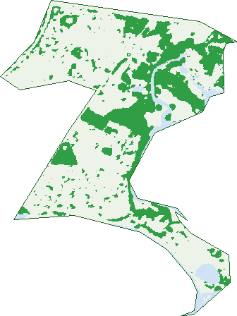
Green: 10 m cells where trees dominate, satellite 2021. Blue: water. The line is the suburb boundary.
| Canopy share, 1 m canopy height map, 2020 | 23.1% |
|---|---|
| Land with trees, 10 m satellite map, 2021 | 27.4% |
Demographics
Unemployment 11% · Labour-force participation 39.6%
Population by age in Coodanup
| 0-4 | 210 |
|---|---|
| 5-14 | 533 |
| 15-19 | 241 |
| 20-24 | 220 |
| 25-34 | 395 |
| 35-44 | 415 |
| 45-54 | 485 |
| 55-64 | 550 |
| 65-74 | 675 |
| 75-84 | 464 |
| 85+ | 170 |
Dwelling types in Coodanup
| House | 1,571 |
|---|---|
| Townhouse | 161 |
| Apartment | 87 |
| Other | 0 |
Households by weekly income in Coodanup
| <$650 | 585 |
|---|---|
| $650-1,499 | 599 |
| $1,500-2,999 | 323 |
| $3,000+ | 137 |
Top ancestries in Coodanup
| English | 1,993 |
|---|---|
| Australian | 1,665 |
| Scottish | 387 |
| Irish | 384 |
| Ancestry NS | 338 |
| Aboriginal | 248 |
Housing tenure in Coodanup
| Owned | 556 |
|---|---|
| Mortgage | 529 |
| Rented | 661 |
| Other | 28 |
Cars per household in Coodanup
| 0 | 152 |
|---|---|
| 1 | 822 |
| 2 | 525 |
| 3 | 190 |
| 4+ | 84 |
Commute to work in Coodanup
| Car | 859 |
|---|---|
| Train | 33 |
| Bus | 28 |
| Tram/ferry | 0 |
| Walked | 14 |
| Bicycle | 4 |
| Home | 67 |
Top countries of birth in Coodanup
| England | 389 |
|---|---|
| New Zealand | 158 |
| Philippines | 81 |
| South Africa | 48 |
| Scotland | 31 |
| Netherlands | 25 |
Languages used at home in Coodanup
| Tagalog | 31 |
|---|---|
| Filipino | 24 |
| Afrikaans | 15 |
| Italian | 12 |
| Thai | 12 |
| Mandarin | 11 |
Birds & Wildlife Nearby
62,908 bird observations recorded near Coodanup — most often seen:
- Australian Pelican (3,722)
- Silver Gull (3,352)
- Little Pied Cormorant (3,263)
- Australian White Ibis (3,218)
- Pacific Black Duck (2,974)
- Australian Raven (2,810)
- Great Egret (2,776)
- Little Black Cormorant (2,467)
- Australian Shelduck (2,448)
- Australasian Darter (2,393)
- Grey Teal (2,202)
- Red Wattlebird (2,147)
- Welcome Swallow (2,147)
Show all 30 birds recorded near Coodanup
- White-faced Heron (2,114)
- Little Egret (2,089)
- Willie Wagtail (2,056)
- Whistling Kite (1,968)
- Galah (1,937)
- Black Swan (1,824)
- Australian Pied Oystercatcher (1,643)
- Pied Cormorant (1,576)
- Yellow-billed Spoonbill (1,531)
- Splendid Fairy-wren (1,405)
- South-western Australian Magpie (1,358)
- Magpie-lark (1,336)
- Australian Ringneck (1,316)
- Grey Butcherbird (1,246)
- Twenty-eight Parrot (1,234)
- Eastern Osprey (1,204)
- Crested Pigeon (1,152)
Sightings reported by observers, not a survey, so the counts show what people record rather than what lives here. Source: Atlas of Living Australia.
Nearby Suburbs
The closest suburbs to Coodanup:
- Furnissdale (1.8 km)
- Dudley Park (1.8 km)
- Greenfields (2.6 km)
- Mandurah (3.2 km)
- Barragup (3.6 km)
- Erskine (4.8 km)
- Silver Sands (4.8 km)
- North Yunderup (5.2 km)
Embed this suburb
Add this free Coodanup stat card to your own site — just copy the code:
Preview:
Cite this page
Quoting these figures? Copy the credit line:
Keep an eye on Coodanup
One email when this data meaningfully changes — new census figures, prices, rankings. No spam, unsubscribe anytime.
Streets
- Abba Lane (8)
- Aboyne Close (8)
- Adare Place (21)
- Albermarle Close (15)
- Alderley Place (6)
- Alma Close (7)
- Angelo Road (11)
- Annie Place (4)
- Arabian Drive (9)
- Bailup Loop (18)
- Beacham Street (58)
- Bertram Street (43)
- Bickley Crescent (28)
- Birchley Road (48)
- Blossom Place (30)
- Blue Wren Gardens (25)
- Brooking Road (40)
- Broun Road (16)
- Buller Road (7)
- Cardigan Close (5)
- Cassowary Crescent (37)
- Casula Avenue (51)
- Chambon Cove (9)
- Claise Lane (19)
- Cleopatra Drive (10)
- Coodanup Drive (29)
- Derek Road (52)
- Duncan Road (34)
- Dunlin Way (3)
- Durack Street (10)
- Duverney Crescent (37)
- Eddy Street (16)
- Emma Way (7)
- Erica Street (69)
- Ethel Close (5)
- Fairlie Place (4)
- Faith Court (5)
- Ferntree Lane (36)
- Foster Road (19)
- Gallinago Loop (14)
- Gavarnie Way (28)
- Gimlet Street (9)
- Glauert Road (22)
- Golden Grove (20)
- Gollan Place (15)
- Grimsel Court (16)
- Harbord Avenue (33)
- Hovea Place (12)
- Iris Court (21)
- Ironstone Lane (38)
- Jarrah Street (8)
- John Street (23)
- Josbury Close (3)
- Kallang Road (42)
- Kalumba Road (9)
- Kanya Place (8)
- Kurdal Road (13)
- Lakewood Parkway (48)
- Landings Boulevard (32)
- Lapwing Road (13)
- Liberton Place (26)
- Lockhart Street (19)
- Maclaggan Turn (216)
- Macquarie Drive (28)
- Maggie Way (11)
- Magill Place (3)
- Mandalup Lane (8)
- Moulton Street (11)
- Nairn Road (61)
- Nalya Court (6)
- Newlyn Way (12)
- Ninda Street (11)
- Norton Avenue (28)
- Oldfield Lane (14)
- Ombersley Way (21)
- Pallid Road (11)
- Pardoo Lane (20)
- Peel Parade (47)
- Pinjarra Road (182)
- Placid Waters Parade (19)
- Powderbark Avenue (19)
- Radiata Street (6)
- Ranceby Avenue (4)
- Rathmines Place (19)
- Revesby Place (15)
- Riverina Avenue (22)
- Riverview Street (16)
- Rosella Way (9)
- Roy Road (67)
- Sandeland Avenue (30)
- Sandover Way (9)
- Scarsdale Avenue (6)
- Sherlock Loop (20)
- Silvergum Avenue (1)
- Songlark Ramble (22)
- Steerforth Drive (125)
- Stringybark Drive (11)
- Stringybark Loop (42)
- Swanson Loop (49)
- Tankerton Way (53)
- Telita Court (11)
- Thornbill Crescent (78)
- Tobol Cove (6)
- Turtledove Circuit (2)
- Underdale Place (18)
- Vaucluse Way (42)
- Veresdale Retreat (22)
- Vianen Close (7)
- Walter Street (6)
- Wamba Road (12)
- Wanjeep Street (58)
- Warbrook Place (17)
- Watson Avenue (39)
- Wellstead Way (21)
- Whimbrel Crescent (59)
- William Road (7)
- Wimba Place (6)